
On this page
World Geography: Some Glimpses is Chapter 1 of Exploring Society: India and Beyond, Part 2, NCERT's Social Science textbook for Grade 8 (book code hees2, First Edition, June 2026). It opens Theme A, India and the World.
CBSE's 2026-27 curriculum page lists syllabi for Classes 9 to 12 only, so Class 8 follows the NCERT book itself. It is assessed by the school, with no official marks to quote.
What does World Geography: Some Glimpses cover?
Three big questions frame it: what makes each continent's physical features distinctive, why world geography matters, and how human actions cause environmental problems. It moves from maps to oceans to landforms on six continents, then to climate, life and sustainable development.
Why does Greenland look so big on some maps?
The chapter calls the Earth an oblate spheroid: nearly round, bulging at the equator and a little flat at the poles. Showing the Earth on a flat sheet is called a map projection, and every projection distorts something.
Two projections are compared. Mercator keeps shapes and directions, which suits navigation, but stretches areas near the poles, so Greenland appears bigger than India even though it is smaller. Robinson balances size and shape distortion. Professionals use latitude and longitude for precision. Our explainer on why Greenland looks so big shows the stretch.
What does the chapter teach about oceans?
Key facts from the chapter:
Oceans cover about 71 per cent of Earth's surface and hold 97 per cent of its water.
Tiny plankton make possible almost half the oxygen we breathe.
The warm Gulf Stream current runs from near the Equator towards Western Europe, keeping the United Kingdom warmer than other places equally far north.
The Mariana Trench, the deepest, reaches over 11,000 metres below sea level at its Challenger Deep.
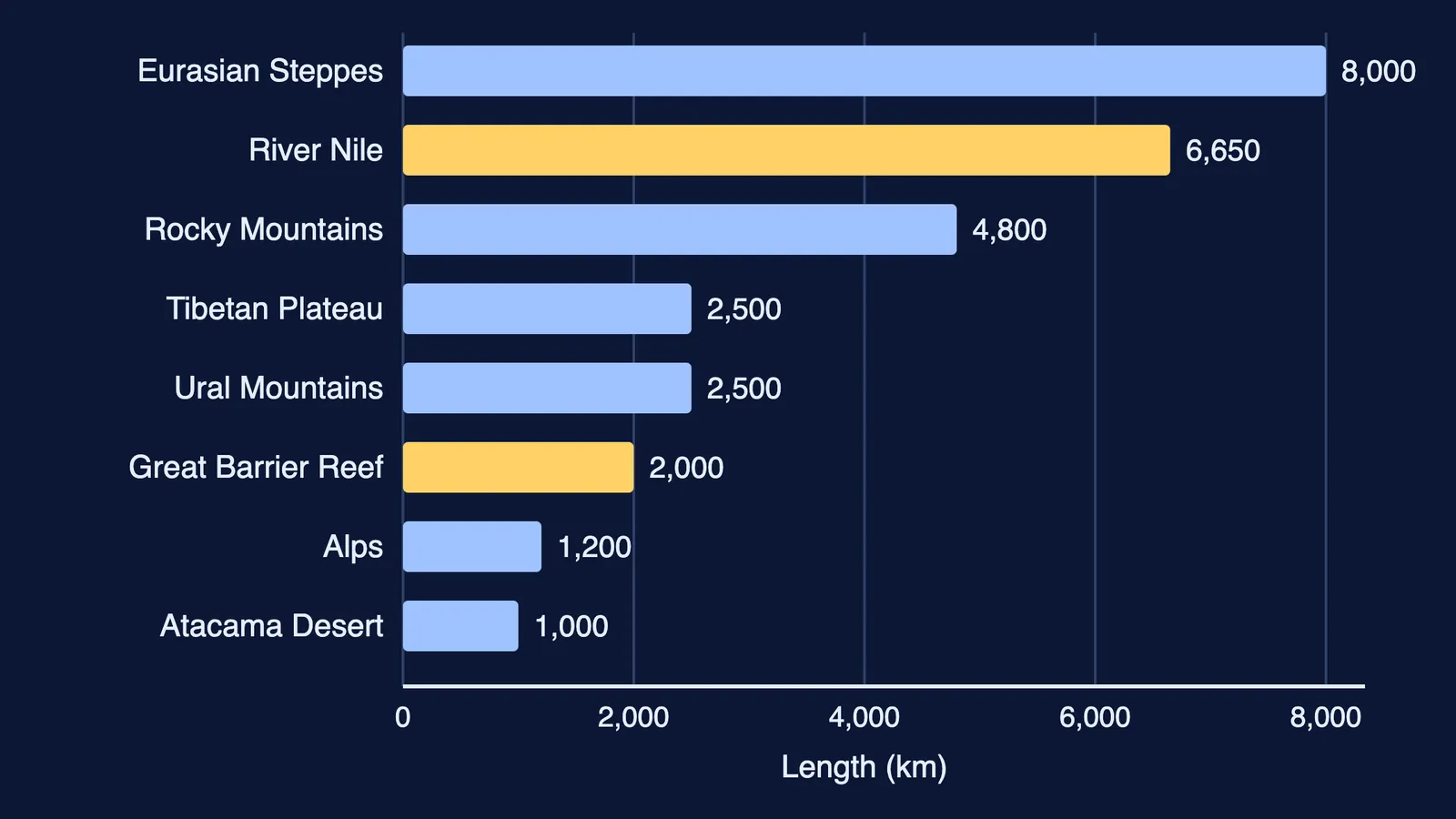
The Great Barrier Reef, off Australia's northeastern coast, stretches over 2,000 km. Reefs shelter about a quarter of all ocean species.
Five waterway types: sea (Arabian Sea), gulf (Persian Gulf), bay (Bay of Bengal, the world's largest bay), strait (Strait of Malacca) and canal (Suez Canal, opened in 1869).
Which landforms does the continent tour visit?
Asia: the Tibetan Plateau, the highest and largest plateau; the Gobi Desert; the Eurasian Steppes, a grassland over 8,000 km long that stores carbon underground; and the Urals, about 2,500 km long, a natural boundary between Europe and Asia.
Europe: the European Plain, one of the world's largest flat lands; and the crescent-shaped Alps, 1,200 km long.
Africa: the Sahara, the largest hot desert; the savannah grassland; and the Nile, almost 6,650 km long and the world's longest river.
South America: the Andes, with Mount Aconcagua and the Uyuni Salt Flats; the Amazon, the largest river by volume; and the Atacama, among the driest places on Earth and one of the fastest-growing dumps for discarded fast-fashion clothes.
North America: the Colorado Plateau and the Grand Canyon, the Rockies (over 4,800 km), the Appalachians, among the oldest ranges; and the five Great Lakes.
Australia: the Great Australian Desert, home to the Spinifex people for over 25,000 years. The book adds that Antarctica, over 14 million sq km, is the largest desert.
Our Class 7 Sahara and Ladakh guide compares a hot and a cold desert.
Worked example: how do you study one feature?
Use a five-line feature card, shown here for the Tibetan Plateau:
Where: north of the Himalayan Range.
How it formed: the Indo-Australian and Eurasian plates collided, which also raised the Himalayas.
Size: about 2,500 km east to west and 1,000 km north to south, with an average height over 4,500 m.
Why it matters: it shapes Asia's climate and feeds the Indus, Brahmaputra and Yangtze.
Pressure: with climate change, snow-melt is enlarging lakes and creating new ones.
The chart above plots the book's lengths. The Steppes (over 8,000 km) divided by the Alps (1,200 km) is about 6.7, so the grassland is nearly seven times as long. The Nile (almost 6,650 km) divided by the Urals (about 2,500 km) is about 2.7. Treat these as rough: the book says "over", "about" or "almost".
Practice questions and what comes next
Mark labels are our suggestion.
(2 marks) Mercator and Robinson each give something up. Say what each trades away, and when a sailor would pick Mercator.
(2 marks) Distinguish a bay from a strait, with one example of each.
(3 marks) How can a warm ocean current change the climate of a coastal country?
(3 marks) Make a feature card for the Sahara or the Andes.
(5 marks) A coastal town lies near a coral reef and a large grassland. Give two benefits each feature offers the town and one human threat to each.
The chapter closes by linking landforms to settlement, farming and trade; Part 2 later turns to Dynamics of Population and India's Urban Landscape. The Class 9 Life on Earth guide on biomes, forests and people goes further.
Not sure where to start revising? Fermi's AI tutor works out what you already know and builds a plan for the session.