
On this page
Water (Oceans) is Chapter 12 of NCERT's Class 11 book Fundamentals of Physical Geography (NCERT, Reprint 2026-27). The CBSE 2026-27 Geography curriculum keeps all three parts: the hydrological cycle, ocean floor relief, and temperature and salinity. Unit V, made up of this chapter and Movements of Ocean Water, carries 4 marks out of 35 for this book, with no separate figure per chapter. Map work, marked separately, lists six seas: Black, Baltic, Caspian, Mediterranean, North and Red.
What is the hydrological cycle?
The hydrological cycle is the continuous movement of water between the oceans, the atmosphere, the land surface and underground, and living things, in liquid, solid and gas form (NCERT, Chapter 12). NCERT pairs each store with its processes: oceans with evaporation and sublimation, the atmosphere with condensation and precipitation, ice with snowmelt runoff, surface water with stream flow and infiltration, groundwater with springs.
About 91 per cent of the planet's water is in the oceans. Of the rain and snow reaching land, nearly 59 per cent evaporates back into the air. NCERT adds that renewable water stays constant while demand rises, so shortages appear, worsened by river pollution. Condensation and rainfall are covered in water in the atmosphere.
What are the relief features of the ocean floor?
Most of the ocean floor lies 3 to 6 km below sea level (NCERT, Chapter 12). Follow a probe sailing straight out from a beach and it crosses the four major divisions in order:
Continental shelf. The shallow edge of a continent, gradient 1° or less, average width about 80 km, depth from 30 m to 600 m. It is nearly absent off Chile and west Sumatra; the Siberian shelf reaches 1,500 km. Its thick sediments become fossil fuels over time.
Continental slope. Gradient 2-5°, depth 200 to 3,000 m. Its edge marks the end of the continent.
Deep sea plain. The flattest regions on Earth, 3,000 to 6,000 m deep, covered with clay and silt.
Oceanic deeps or trenches. Narrow basins 3-5 km deeper than the floor around them, tied to volcanoes and earthquakes. Of 57 deeps explored, 32 are in the Pacific, 19 in the Atlantic and 6 in the Indian Ocean.
Minor features: mid-oceanic ridges (Iceland is part of the mid-Atlantic Ridge), seamounts (volcanic, 3,000-4,500 m tall, below the surface), guyots (flat-topped seamounts), submarine canyons (the Hudson Canyon) and atolls (coral reefs around a central depression). How these floors formed is in distribution of oceans and continents.
How does ocean temperature change with latitude and depth?
NCERT gives four factors: latitude, the unequal spread of land and water, prevailing winds (offshore winds cause upwelling of cold water; onshore winds pile up warm water) and ocean currents, such as the warm Gulf Stream and the cold Labrador current (NCERT, Chapter 12).
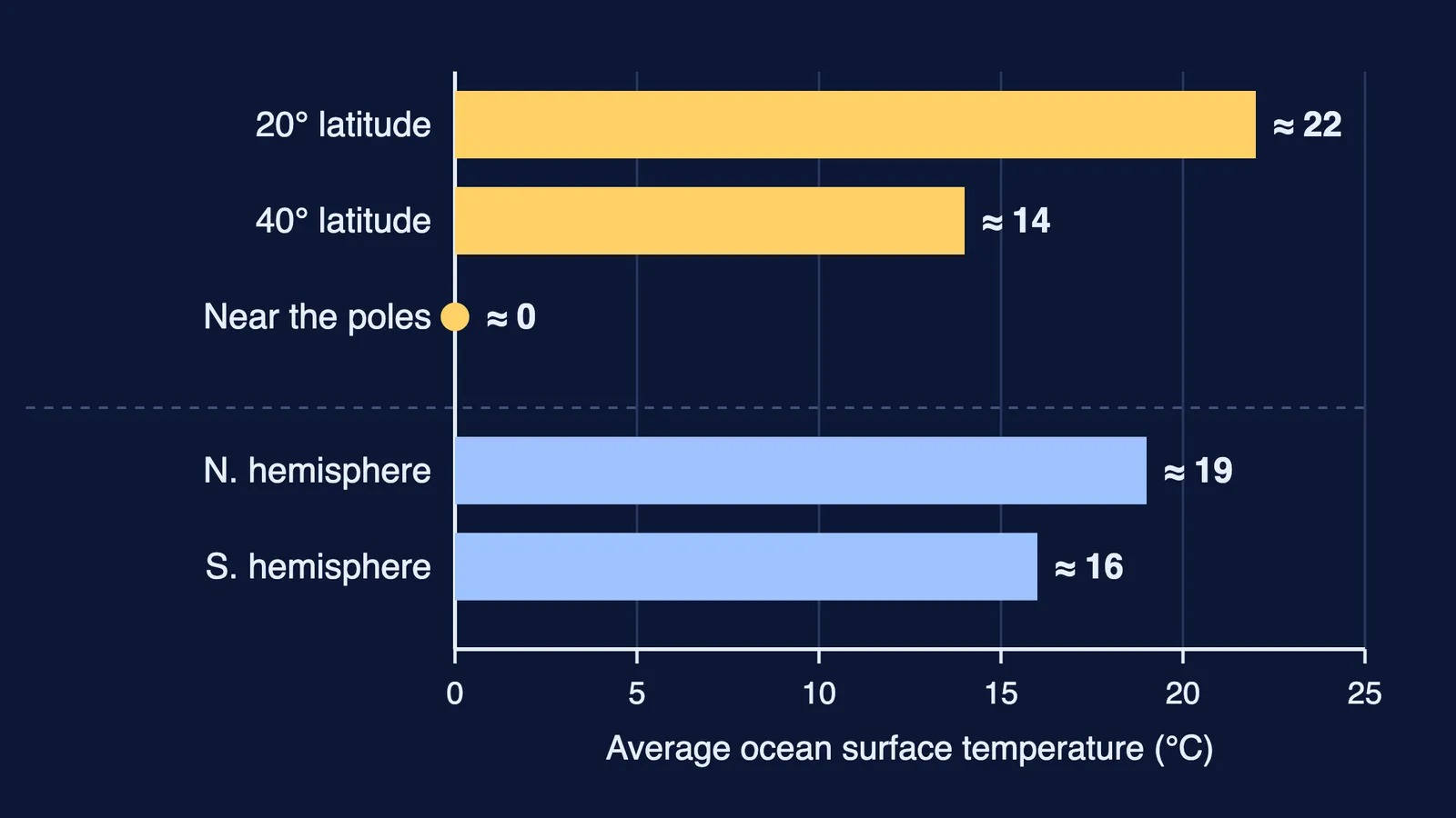
Surface water averages about 22°C at 20° latitude, 14°C at 40° and 0°C near the poles, as the chart shows. The northern hemisphere averages about 19°C against 16°C in the southern, because it has more land. The warmest water lies slightly north of the equator.
Down the column, low and middle latitudes have three layers:
Warm top layer, about 500 m thick, 20° to 25°C; all year in the tropics, only in summer in mid latitudes.
Thermocline, 500 to 1,000 m thick, where temperature falls fast with depth.
Cold deep layer down to the floor, near 0°C. About 90 per cent of ocean water lies below the thermocline.
Inside the Arctic and Antarctic circles, surface water is near 0°C and one cold layer runs from surface to floor.
Why is some sea water saltier than the rest?
Salinity is the grams of salt dissolved in 1,000 g of sea water, written in parts per thousand (‰) (NCERT, Chapter 12). Water below 24.7‰ counts as brackish. Open ocean ranges from 33‰ to 37‰. Evaporation raises salinity; rain, rivers and melting ice lower it.
Explain each example by its cause:
Red Sea, up to 41‰: landlocked.
Mediterranean, high: high evaporation.
North Sea, high for its latitude: salty water brought by the North Atlantic Drift.
Baltic and Black Seas, low: large river inflow.
Arabian Sea higher than Bay of Bengal: more evaporation, less river water.
The Atlantic averages about 36‰ and the Indian Ocean 35‰. With depth, salinity generally rises; the zone of sharp rise is the halocline, and saltier, denser water sinks below fresher water. Waves, tides and currents follow in movements of ocean water.
Practice questions for Water (Oceans) class 11
(1 mark) Name the zone where salinity increases sharply with depth.
(3 marks) A ship sails from the Arabian Sea to the Bay of Bengal. Explain the change in surface salinity it records.
(3 marks) Why is the northern hemisphere's ocean surface warmer on average than the southern?
(5 marks) Describe the four major divisions of the ocean floor in order from the coast, with one figure for each.
(5 marks) Explain how winds and currents change ocean temperature, with one example of each.
Fermi's AI tutor can work out what you already know and build a plan for the session, so you sit down to a clear next step.