
On this page
Climate is Chapter 4 of NCERT's Class 11 book India: Physical Environment (NCERT, 2026-27 edition). The CBSE 2026-27 Geography curriculum keeps every section of the chapter. The curriculum prints one weightage of 12 marks for Unit III, shared by Chapter 4 Climate and Chapter 5 Natural Vegetation, out of 35 for this book; there is no separate figure for Climate. Map work, marked separately, asks for the areas of highest and lowest temperature and rainfall.
What is the difference between weather and climate?
Weather is the air's state at a moment; climate is the average of weather over a long period, and NCERT says a change in it may show only after 50 years or more (NCERT, Chapter 4). A monsoon climate is one where winds reverse direction with the seasons.
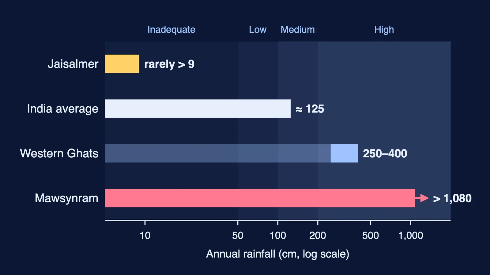
The contrasts inside India are huge, as the chart shows. Jaisalmer rarely gets more than 9 cm of rain a year, India's average is about 125 cm, the windward Western Ghats get 250 to 400 cm, and Cherrapunji and Mawsynram get over 1,080 cm.
What factors determine the climate of India?
NCERT lists six (Chapter 4):
Latitude. South of the Tropic of Cancer is tropical, with a small temperature range; the north has a larger daily and annual range.
The Himalayas. They block cold northern winds and trap the monsoon within the subcontinent.
Land and water. Land heats and cools faster than sea, so pressure zones shift and winds reverse.
Distance from the sea. Mumbai is equable; Delhi, Kanpur and Amritsar have extremes.
Altitude. Agra and Darjiling share a latitude, yet January averages 16°C in Agra and 4°C in Darjiling.
Relief. Windward slopes get heavy rain; the leeward southern plateau stays dry.
How does the Indian monsoon work?
Learn it as a chain; a missing link costs marks:
In summer the northwest heats up and forms an intense low; the ocean to the south keeps higher pressure.
The Inter Tropical Convergence Zone (ITCZ), a low-pressure belt where trade winds meet, moves to about 20°N-25°N over the Gangetic plain in July. This is the monsoon trough.
Southeast trades cross the equator at longitudes 40°E to 60°E, are turned by the Coriolis force, and become the southwest monsoon.
The westerly jet stream withdraws from the north Indian plain and an easterly jet sets in along 15°N; NCERT links this jet to the burst of the monsoon.
The monsoon reaches Kerala by 1 June, Mumbai and Kolkata between 10 and 13 June, and the whole country by mid-July.
A dry spell of a week or more in the rainy season is a break in the monsoon. Pressure belts and jet streams are covered in atmospheric circulation and weather systems.
What are the four seasons of India?
NCERT uses the four seasons recognised by meteorologists:
Cold weather season, from mid-November in the north. Mediterranean depressions bring light winter rain that helps rabi crops; Delhi averages about 53 mm.
Hot weather season, April to June in the north, with about 48°C in the northwest in May. Local storms: mango showers in Kerala, Nor Westers (Kalbaisakhi) in Bengal and Assam, and the Loo across the northern plains.
Southwest monsoon season. The Arabian Sea branch drenches the Western Ghats and leaves a rain shadow to the east. The Bay of Bengal branch is deflected by the Arakan Hills into the Ganga plains and the Brahmaputra valley. The Tamil Nadu coast stays dry: it lies parallel to the Bay branch and in the rain shadow of the Arabian Sea branch.
Retreating monsoon, October and November. Humid "October heat" in the north; cyclones from the Andaman Sea bring heavy rain to the Coromandel coast.
How is rainfall distributed across India?
NCERT sorts areas into four bands (Chapter 4):
Over 200 cm: west coast, Western Ghats, sub-Himalayan northeast, Meghalaya hills.
100 to 200 cm: southern Gujarat, east Tamil Nadu, Odisha, Jharkhand, Bihar, eastern Madhya Pradesh.
50 to 100 cm: western Uttar Pradesh, Delhi, Haryana, Punjab, eastern Rajasthan, the Deccan Plateau.
Under 50 cm: parts of the Peninsula, Ladakh and most of western Rajasthan.
NCERT notes that about 64 per cent of people depend on agriculture, which runs on the southwest monsoon. On global warming, it projects about 2°C of warming by 2100 and a 48 cm sea-level rise by the century's end. To place these regions, revise India's location and physiography.
Practice questions for Climate class 11
(1 mark) Which force turns the southeast trades into southwesterly winds after they cross the equator?
(3 marks) Pune gets far less June-September rain than the Konkan coast. Explain using relief.
(3 marks) Give three reasons for the cold in north India in December and January.
(5 marks) Trace the monsoon from summer heating to its arrival over Kerala in five steps.
(5 marks) Why does Chennai get most of its rain in October and November?
If one link of the monsoon chain keeps slipping, Fermi's AI tutor can work out what you already know and build a plan for the session.