
On this page
This chapter is one chain: pressure differences make wind, rotation bends it, belts and cells organise it, and air masses and cyclones are what you feel as weather.
Is this chapter in the Class 11 syllabus for 2026-27?
Yes. The CBSE Geography curriculum for 2026-27 lists Chapter 9 under Unit IV Climate of Fundamentals of Physical Geography. The Climate unit, Chapters 7 to 11, carries 8 of the 35 marks for this book. Within this unit, only Chapter 11, World Climate and Climate Change, is left out of the written paper: it is tested through internal assessment as a project and presentation. The NCERT chapter PDF is marked "Reprint 2026-27".
What makes the wind blow?
The NCERT chapter defines atmospheric pressure as the weight of a column of air over a unit area, from mean sea level to the top of the atmosphere. Average sea-level pressure is 1,013.2 millibar (mb). In the lower atmosphere, pressure falls by about 1 mb for every 10 m you climb.
Air moves from high to low pressure. Three forces shape surface wind:
Pressure gradient force: strong where isobars are close, weak where they are far apart.
Friction: greatest at the surface, reaching up to 1-3 km; smallest over the sea.
Coriolis force: from Earth's rotation, it deflects wind right in the northern hemisphere and left in the southern. It is zero at the equator and greatest at the poles.
Strictly, the Coriolis effect depends on the sine of latitude, 2Ω sin(latitude), where Ω is Earth's rotation rate, as these MIT fluid dynamics notes derive. So, NCERT notes, a low near the equator fills up instead of spinning into a tropical cyclone.
Above 2-3 km, with no friction and straight isobars, the pressure gradient and Coriolis forces balance and the wind blows parallel to the isobars: the geostrophic wind. Around a low, winds turn anticlockwise in the northern hemisphere and clockwise in the southern; around a high, the reverse. Buys Ballot's law turns this into a rule you can use outdoors.
What are the pressure belts and the three cells?
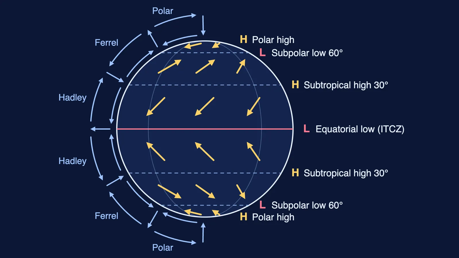
The NCERT chapter names four belts per hemisphere: the equatorial low, the subtropical highs near 30°, the subpolar lows near 60°, and the polar highs. They shift south in the northern winter and north in summer, following the apparent movement of the sun.
Three cells link the belts:
Hadley cell: air rises at the Inter Tropical Convergence Zone (ITCZ) to about 14 km, moves poleward, sinks near 30° and returns as the easterlies (trade winds).
Ferrel cell: in mid-latitudes, surface air flows poleward as the westerlies.
Polar cell: cold air sinks at the poles and flows out as the polar easterlies. NOAA's guide to global circulation calls it the smallest and weakest cell.
An exercise asks you to draw this and explain the subtropical high. Use this order:
Draw a circle; mark 0°, 30° and 60° in both hemispheres.
Label each belt L or H.
Draw three loops: air rises at 0° and 60°, sinks at 30° and the poles.
Add surface winds: north-east trades, westerlies and polar easterlies, mirrored in the south.
Explain the high: air piles up aloft near 30°, cools and sinks.
If the loops feel abstract, the Fermi Simulation Lab has interactive simulations for ideas that are easier to see than to read.
How do air masses and fronts form?
An air mass is a large body of air with little horizontal variation in temperature and moisture, as the NCERT chapter defines it. The five types are maritime tropical (mT), continental tropical (cT), maritime polar (mP), continental polar (cP) and continental arctic (cA).
Where two air masses meet, the boundary is a front: cold, warm, stationary or occluded. Extra-tropical cyclones grow along the polar front. Warm air glides over cold air, the faster cold front catches up, and once the warm air is fully lifted the front is occluded and the cyclone dies.
How is a tropical cyclone different from an extra-tropical cyclone?
The NCERT chapter gives these contrasts:
Extra-tropical cyclones have fronts; tropical cyclones do not.
Extra-tropical cyclones form over land or sea and cover more area; tropical cyclones form only over seas and die out on land.
Tropical cyclones have far stronger winds.
Extra-tropical cyclones move west to east; tropical ones east to west.
Favourable conditions for a tropical cyclone: a large sea surface warmer than 27° C, the Coriolis force, little change in wind speed with height, an existing weak low, and divergence aloft. Eye-wall winds can reach 250 km per hour, and storms over the Bay of Bengal and Arabian Sea span 600-1,200 km. For India's pattern, read why India gets cyclones in May and November and why cyclones weaken after landfall.
If pressure gradients or rotation still feel shaky, the Fermi Concept Library covers every concept in physics, chemistry, biology, mathematics and computing, so you can fix it before the next chapter builds on it.