
On this page
When a cyclone crosses the Odisha or Andhra Pradesh coast, its winds start to drop. The storm loses the warm sea that fuels it, and its winds rub against trees, buildings and hills: latent heat and friction.
Where does a cyclone get its energy?
A tropical cyclone is a heat engine that runs on warm seawater. NOAA's JetStream weather school says these storms need ocean water of at least 27°C (80°F) through a depth of about 150 feet (NOAA JetStream).
Evaporation stores energy in water vapour; when moist air rises and cools, the vapour condenses and releases it as heat. NOAA describes the next step: the released heat warms the atmosphere, "making the air lighter, which then continues to rise" (NOAA JetStream). The rising air pulls in more moist air at the surface, and the cycle keeps going.
For why vapour holds so much energy, see why latent heat of vaporisation is larger than fusion.
Why do cyclones weaken after making landfall?
1. The fuel line is cut. Over land there is no warm sea to evaporate from, so the inflowing air carries less latent heat. NOAA puts it plainly: once the eye moves over land the storm begins to weaken rapidly, "not because of friction, but because the storm lacks the moisture and heat that the ocean provided" (NOAA JetStream). Fewer thunderstorms form near the centre, and the storm fades.
2. Rough ground drags on the winds. Forests, buildings and hills increase surface drag, which takes kinetic energy out of the wind near the ground.
Jie Chen and Daniel Chavas of Purdue University made the surface under a simulated mature storm suddenly rougher, drier, or both (Journal of the Atmospheric Sciences, 2021). Their earlier 2020 study had found that each change weakens the storm by a different route. Here, roughening "dominates decay within the first few hours", and the very fast drop in near-surface wind in the first 10 minutes behaves like a simple frictional spin-down (preprint on arXiv).
How fast does a cyclone weaken over land?
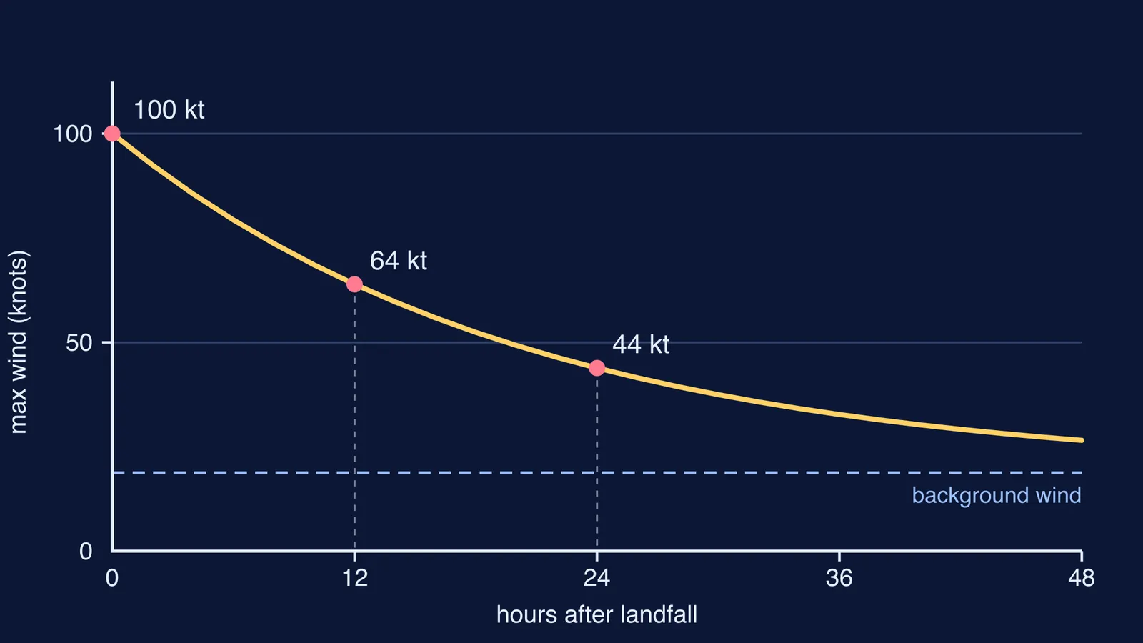
The standard empirical model, first published by Kaplan and DeMaria in 1995, treats the decay as exponential: V(t) = Vb + (V0 − Vb)e^(−αt), where V0 is the maximum wind at landfall, Vb is a weak background wind and α is the decay rate (Chen and Chavas, arXiv). Fitted to historical Atlantic hurricanes, Vb = 18.82 knots and α = 0.049 per hour, as estimated by Jing and Lin in 2019 and reported in the same paper.
For India, India Meteorological Department (IMD) scientists built an exponential decay model from 19 cyclones that crossed India's east coast (Roy Bhowmik, Kotal and Kalsi, 2005). For the Odisha super cyclone of October 1999, an IMD study found the maximum wind fell exponentially, with a decay constant of 0.0991 per hour (Kalsi, Kotal and Roy Bhowmik, MAUSAM, 2003).
Worked example: how much wind is left a day after landfall?
One knot is 0.5144 m/s (Roy Bhowmik and colleagues), so a 100-knot storm has winds of about 185 km/h. Use the Atlantic values Vb = 18.82 knots and α = 0.049 per hour (Chen and Chavas, arXiv):
Extra wind above background at landfall: 100 − 18.82 = 81.18 knots.
After 12 hours: e^(−0.049 × 12) = e^(−0.588) ≈ 0.555, so V ≈ 18.82 + 81.18 × 0.555 ≈ 64 knots.
After 24 hours: e^(−1.176) ≈ 0.309, so V ≈ 18.82 + 25.0 ≈ 44 knots.
The extra wind halves every ln 2 / α = 0.693 / 0.049 ≈ 14 hours.
Now put the Odisha 1999 decay constant of 0.0991 per hour (MAUSAM, 2003) into step 4: 0.693 / 0.0991 ≈ 7 hours. A decay constant about twice as large means the extra wind halves in about half the time.
Are cyclones now weakening more slowly over land?
Lin Li and Pinaki Chakraborty studied North Atlantic hurricanes that made landfall over the past 50 years (Nature, 2020). In their words, in the late 1960s a typical hurricane "lost about 75 per cent of its intensity in the first day past landfall", while now the decay is only about 50 per cent. Their explanation fits the fuel story: warmer seas let a storm carry more moisture onto land, which slows its weakening.
These are Atlantic figures, not Indian ones. For the Indian side, read why the Bay of Bengal gets more cyclones than the Arabian Sea and how a storm surge floods the coast.
How do you explain it in an exam answer?
Use this order for a 3- to 5-mark answer (NOAA JetStream):
Energy source: evaporation from warm sea water, at least about 27°C.
Mechanism: latent heat released on condensation warms the air, which rises and keeps the storm going.
Landfall: no warm sea, less latent heat, fewer thunderstorms near the centre, so the storm weakens.
Friction: rough land slows the winds near the ground, fastest in the first hours.
The Fermi Simulation Lab has interactive simulations for ideas that are easier to see than to read, and the Fermi Concept Library gives every physics concept its own lesson and its place in the map.
Next time a cyclone crosses the coast, track its reported winds for a day and compare them with your decay curve.