
On this page
India's east coast watches the sea most closely in May and November. The timing comes from two ingredients, warm water and low wind shear, and the India Meteorological Department (IMD) has the numbers.
When does India get the most cyclones?
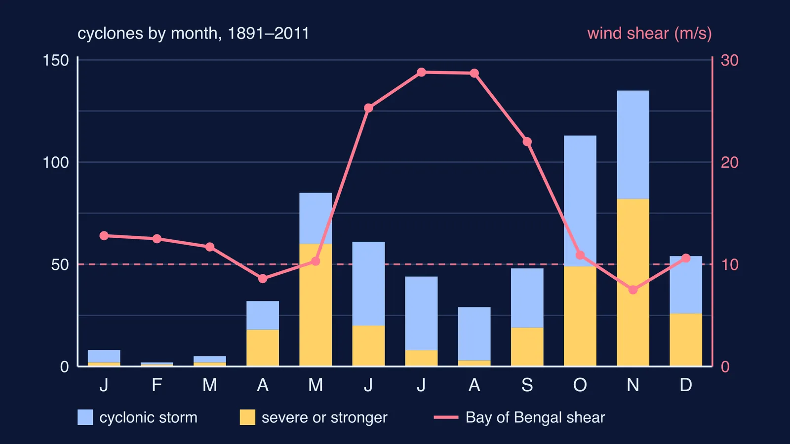
IMD's frequently asked questions on tropical cyclones says the monthly frequency of cyclones over the north Indian Ocean is bimodal, with a primary peak in November and a secondary peak in May. It puts the average at about 5 cyclones a year over the Bay of Bengal and Arabian Sea, with about four in the Bay for every one in the Arabian Sea. IMD defines a cyclonic storm as a low-pressure system whose 3-minute sustained winds reach 34 knots, about 62 km/h; weaker systems are depressions or deep depressions.
The chart above uses month-by-month counts from IMD's Cyclone Warning in India standard operation procedure, which covers 1891 to 2011. Over those 121 years, counting severe storms too, October and November each had more than a hundred cyclonic storms, with November highest and May next. July and August had far fewer, even though August had the most depressions. The SOP says more than 80% of all cyclonic disturbances occur between June and November, peaking in August. Most monsoon systems never grow into cyclones.
What does a cyclone need to form?
The IMD FAQ lists the conditions. Two of them decide the season:
Warm ocean water of at least 26.5°C, down to a depth on the order of 50 m.
Vertical wind shear below about 10 m/s (20 knots) between 1.5 km and 12 km up.
Vertical wind shear is the change in wind speed or direction with height. The others are air that is unstable to rising moist convection, moist air about 5 km up, a spot at least 500 km from the equator so Earth's rotation can set up the spin, and a weak disturbance to grow from.
IMD describes a cyclone as a heat engine fuelled by warm water and humid air, releasing energy when vapour condenses into rain. Strong shear acts like a crosswind on a chimney: it tilts the rising column of warm air and stops the storm's thunderstorms organising around its centre.
Why are there so few cyclones during the monsoon?
According to the IMD FAQ, the southwest monsoon brings strong westerly winds below 5 km and very strong easterly winds above 9 km. Opposite winds at the two levels make shear very high. Systems also tend to form further north, in the north Bay of Bengal, and depressions there cross the Odisha and West Bengal coast in a day or two, with too little time over the sea to strengthen.
An IMD training presentation on cyclone climatology plots the shear month by month. Over the Bay of Bengal it climbs to roughly 25-29 m/s from June to August and falls to roughly 7.5-11 m/s in April-May and October-November. The same charts show the Bay's surface water at its warmest, close to 30°C, in May. For the monsoon winds themselves, see what causes the Indian monsoon.
Why May and November, exactly?
Think of each year as having two open windows.
April-May, before the monsoon: the sea is at its warmest and shear is still low. The window closes in June, when the monsoon winds arrive. Cyclone Amphan, which formed in the Bay of Bengal in mid-May 2020 and made landfall over the Sundarbans in West Bengal, is listed in the IMD climatology presentation.
October-November, after the monsoon withdraws: shear drops again while the sea is still well above 26.5°C, so November becomes the bigger peak. The Odisha super cyclone crossed the coast near Paradip on 29 October 1999, and a super cyclone hit Chirala in Andhra Pradesh on 19 November 1977 (IMD FAQ).
IMD notes that May-June and October-November produce cyclones of severe intensity, while July to September cyclones are generally not so intense. Why most start in the Bay rather than the Arabian Sea is explained in why the Bay of Bengal has more cyclones.
How do you answer this in an exam?
A five-mark geography or science answer can follow this plan:
State the pattern and its source: IMD records show two peaks, mainly November and then May.
Give the two key conditions from the IMD FAQ: sea surface at least 26.5°C, and vertical wind shear below about 10 m/s.
Pre-monsoon: the warmest sea and low shear make May favourable.
Monsoon: westerlies below and easterlies above create strong shear, and depressions reach land quickly.
Post-monsoon: shear falls as the monsoon retreats while the sea stays warm, giving the main peak.
Then sketch the chart from memory: bars for cyclones, a line for shear, with the line's two low stretches, April-May and October-November, under the two peaks. If shear is hard to picture, the Fermi Simulation Lab has interactive simulations for ideas that are easier to see than to read.
Curious where names like Amphan come from? Read how cyclones in India get their names.