

On this page
Every year between late May and early June, a massive atmospheric reversal sweeps across South Asia. The prevailing dry winter breezes give way to steady, moisture-laden southwesterly winds that deliver over 70% of India's annual rainfall, as documented by National Geographic. While often perceived simply as seasonal clouds, physicists and meteorologists recognize the monsoon as a planetary-scale heat engine driven by specific heat capacity, buoyant convection, and Earth's rotation.
Why does land heat up faster than the Indian Ocean?
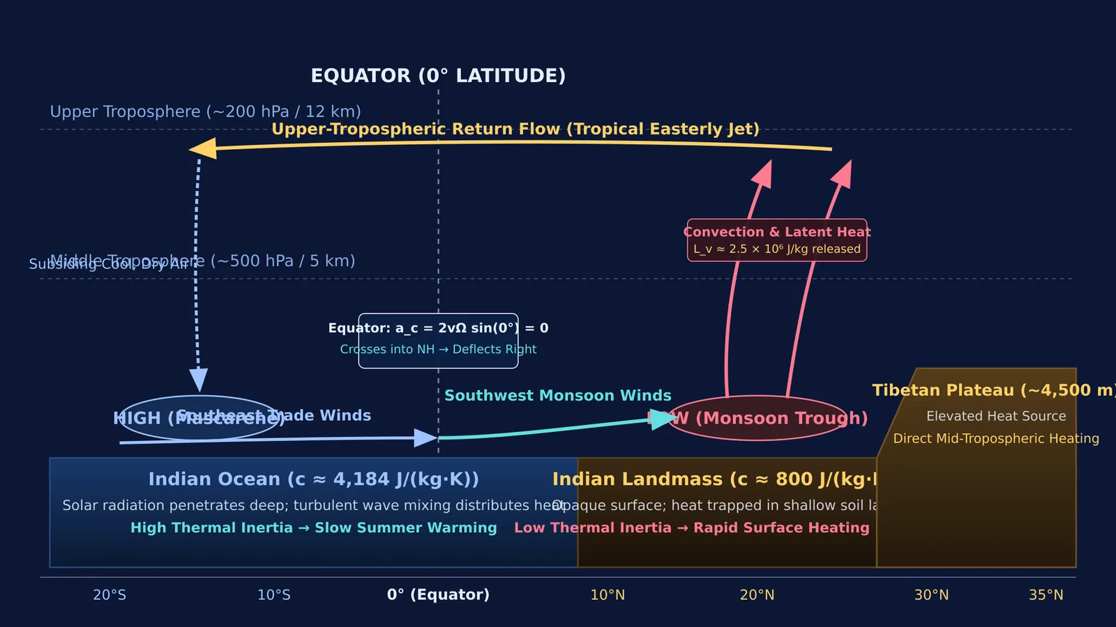
The monsoon engine begins with specific heat capacity. Liquid water has a specific heat capacity of approximately 4,184 J/(kg·K), whereas dry rock and soil range between 800 and 840 J/(kg·K), as compiled in OpenStax University Physics. Warming a kilogram of soil requires barely one-fifth the thermal energy needed to warm an equal mass of seawater by the same temperature increment.
Optical and mechanical factors widen this contrast. Sunlight strikes opaque land and is absorbed within millimetres of topsoil. Because dry soil has low thermal conductivity, absorbed heat stays concentrated in a thin surface skin, pushing May daytime surface temperatures above 45 °C across northwest India. In contrast, solar radiation penetrates tens of metres into transparent ocean water, and turbulent wind mixing redistributes that energy through an oceanic mixed layer often tens of metres deep.
Consider this energy balance:
An ocean mixed layer of 1 m depth (mass ≈ 1,000 kg/m²) absorbing 8.4 × 10⁴ J over one hour warms by ΔT = Q / (m × c) ≈ 0.02 °C.
Dry topsoil with a 5 cm skin depth (mass ≈ 75 kg/m²) absorbing the same 8.4 × 10⁴ J warms by ΔT ≈ 1.33 °C per hour.
Students examining thermal boundaries in the Fermi Concept Library can explore how this thermal inertia gap drives atmospheric circulation.
How does convection create the continental monsoon trough?
As northern India bakes under the summer sun, air in contact with the ground warms by conduction. By the ideal gas equation (P = ρRT), heating air reduces its density (ρ) at constant pressure. Cooler, denser surrounding air forces this buoyant column upward, initiating persistent regional convection.
As rising air diverges aloft, surface barometric pressure drops, establishing the continental monsoon trough across northern India. As meteorologist Sulochana Gadgil showed (Annual Review of Earth and Planetary Sciences, 2003), this intense continental heating pulls the Intertropical Convergence Zone (ITCZ) north from the equator, anchoring the planetary convergence belt across the subcontinent. The elevated Tibetan Plateau—averaging over 4,000 metres in altitude—further accelerates this engine by absorbing solar radiation and heating the middle troposphere directly.
Why do monsoon winds bend from southeast to southwest?
Air flows naturally down the horizontal pressure gradient from high pressure toward low pressure. As early as 1686, Edmond Halley (Philosophical Transactions of the Royal Society) identified differential solar heating between land and sea as the primary driver of these prevailing flows. South of the equator, persistent oceanic high pressure drives maritime air northward as southeast trade winds.
Once these winds cross the equator (0° latitude), Earth's rotation introduces a Coriolis acceleration: a_c = 2 × v × Ω × sin φ
Here v is wind speed, Ω is Earth's angular velocity (7.292 × 10⁻⁵ rad/s), and φ is latitude. At the equator, sin(0°) = 0, so lateral deflection is zero. As air enters the Northern Hemisphere (φ > 0), the Coriolis acceleration acts to the right of the motion vector, veering the southeasterly trades into southwesterly winds.
This wind reversal links thermodynamics directly to planetary dynamics. You can explore how early scientists mapped these global circulation shifts in our profile of Gilbert Walker's southern oscillation work.
What happens during monsoon active and break spells?
Monsoon rainfall does not arrive as an uninterrupted stream. Instead, it pulses between active and break periods, a cycle first mapped from satellite cloud bands by D. R. Sikka and Sulochana Gadgil (Monthly Weather Review, 1980108<1840:otmcza>2.0.co;2)).
As quantified by M. Rajeevan, Sulochana Gadgil, and Jyoti Bhate (Journal of Earth System Science, 2010), these fluctuations depend directly on the spatial alignment of the monsoon trough:
Active Spells: The trough axis aligns across central India. Low-pressure depressions from the Bay of Bengal travel westward along the trough corridor, delivering widespread, soaking rain across the core agricultural plains.
Break Spells: The trough migrates northward to the Himalayan foothills. Rainfall over central and peninsular India drops drastically, while intense downpours batter the Himalayan slopes and northeast India, frequently triggering river flooding in the Brahmaputra basin.
These intraseasonal swings proved vital for long-range forecasting, as detailed in our study of Jagadish Shukla's monsoon predictability discoveries.
How can students connect thermodynamics to atmospheric physics?
In standard physics curricula, such as OpenStax University Physics, the Indian monsoon connects four foundational principles:
Specific Heat Disparity: Use Q = mcΔT to contrast rapid land warming with ocean thermal inertia.
Convective Buoyancy: Connect ideal gas density variations to Archimedean buoyant uplift and low-pressure formation.
Coriolis Steering: Apply rotating reference frames to explain why cross-equatorial winds veer to the right.
Phase Changes: Factor in latent heat of vaporization (L_v ≈ 2.5 × 10⁶ J/kg) as a convective driver.
Interactive models help clarify these coupled mechanisms. In the Fermi Simulation Lab, students can adjust fluid densities and rotation rates to observe how thermal gradients evolve into steady circulation cells. For step-by-step problem sets on heat and gas laws, the Fermi Problem Library explains the underlying reasoning rather than just printing final answers. You can also consult our guide on calorimetry and heat transfer methods to strengthen your problem-solving skills.


