
On this page
When a storm over the Bay of Bengal is called Montha or Ditwah, that name was chosen years earlier and waited its turn in a queue. Here is how the queue works, and how to read it yourself.
How are cyclones named in the north Indian Ocean?
The India Meteorological Department (IMD) runs the Regional Specialised Meteorological Centre in New Delhi, one of six such centres recognised by the World Meteorological Organization, and it names storms over the Bay of Bengal and the Arabian Sea, according to IMD's cyclone FAQ.
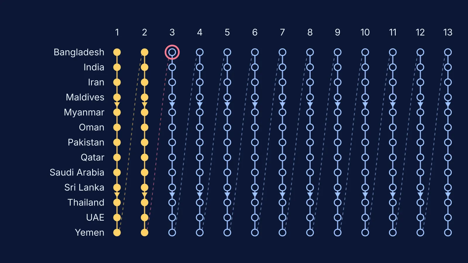
The names come from the 13 member countries of the WMO/ESCAP Panel on Tropical Cyclones: Bangladesh, India, Iran, Maldives, Myanmar, Oman, Pakistan, Qatar, Saudi Arabia, Sri Lanka, Thailand, the UAE and Yemen. Each sent 13 names, making a list of 169 that the panel adopted in April 2020, according to IMD's naming document. It replaced the first list, in use since 2004, which ended with Amphan.
Why does a storm get a name only at 62 km/h?
IMD's cyclone FAQ grades low-pressure systems by their maximum sustained wind, averaged over 3 minutes:
Depression: 17-27 knots (31-49 km/h)
Deep depression: 28-33 knots (50-61 km/h)
Cyclonic storm: 34-47 knots (62-88 km/h)
Severe to extremely severe cyclonic storm: 48-119 knots (89-221 km/h)
Super cyclonic storm: 120 knots (222 km/h) or more
The naming document says a storm gets the next name once it is analysed with maximum winds of 34 knots or more. So any named storm is already at least a cyclonic storm.
Names are easier to remember than numbers and avoid mix-ups when two storms are active, the document explains. On 27 November 2025, one IMD advisory tracked Cyclonic Storm Ditwah near Sri Lanka and the remains of Senyar over the Strait of Malacca at once.
The spin itself is physics. IMD's FAQ explains that Earth's rotation deflects inflowing winds to the right in the Northern Hemisphere, so these storms turn anticlockwise (more in why cyclones spin anticlockwise). If that is hard to picture, the Fermi Simulation Lab has interactive simulations for ideas that are easier to see than read.
Who chooses the names, and what are the rules?
The panel can reject any proposed name that breaks its rules. According to IMD's naming document, a name must:
be neutral to politics and political figures, religious beliefs, cultures and gender
not hurt the sentiments of any group, and not be rude or cruel
be short, easy to pronounce and no longer than eight letters
come with its pronunciation, meaning and a voice-over
be new, and not appear on any other regional centre's list
Once used, a name is retired for good. India's 13 names are Gati, Tej, Murasu, Aag, Vyom, Jhar, Probaho, Neer, Prabhanjan, Ghurni, Ambud, Jaladhi and Vega.
How do you read the cyclone name list?
In the official table, countries run alphabetically down the side, across 13 columns. IMD uses it column by column, top to bottom, from column 1 to column 13.
Try Montha, Thailand's name in column 2. Thailand is row 11, so Montha is 13 × 1 + 11 = 24th. On 28 October 2025, IMD said Montha's landfall had begun and it was expected to cross the Andhra Pradesh coast around Kakinada as a severe cyclonic storm, with winds of 90-100 km/h gusting to 110 km/h (AIR News).
Senyar (UAE, 25th) and Ditwah (Yemen, 26th) followed in November 2025, as the IMD advisory shows, closing column 2. The 27th name, at the top of column 3, is Arnab from Bangladesh, then India's Murasu. Check India's last name yourself: Vega sits in row 2, column 13, so it is 13 × 12 + 2 = 158th.
What do IMD's cyclone warnings mean for your family?
The name is a label. The warning stage tells you what to do. IMD has used four stages since 1999, according to its cyclone FAQ:
Pre-cyclone watch: a depression has formed and may affect the Indian coast, at least 72 hours before bad weather.
Cyclone alert: at least 48 hours ahead, with the storm more than 500 km from the coast.
Cyclone warning: at least 24 hours ahead, within 500 km, with the likely time and place of landfall.
Post-landfall outlook: about 12 hours before landfall, within 200 km, naming inland areas at risk.
Heavy rain usually starts 9-12 hours before landfall, and gales 6-9 hours before. A family plan drawn from IMD's advice:
Watch: check torches, spare batteries and a radio; store drinking water and food that needs little cooking.
Alert: bring in or tie down loose objects, and know your route to higher ground.
Warning: leave low-lying beaches early, and move at once if officials ask you to evacuate.
During the storm: trust All India Radio and RSMC New Delhi over forwarded messages. If the wind drops as the eye passes, stay inside; it returns from the opposite direction.
Next, read how Doppler weather radar tracks storms and how physics models and AI forecast the weather.