
On this page
Every forecast on your phone starts with measurements of the air right now. For decades those measurements went into physics equations run on supercomputers. Now AI models that learned from past weather are matching them. Here is how both work, where AI does well, and why monsoon forecasts are still hard.
How do physics-based weather models work?
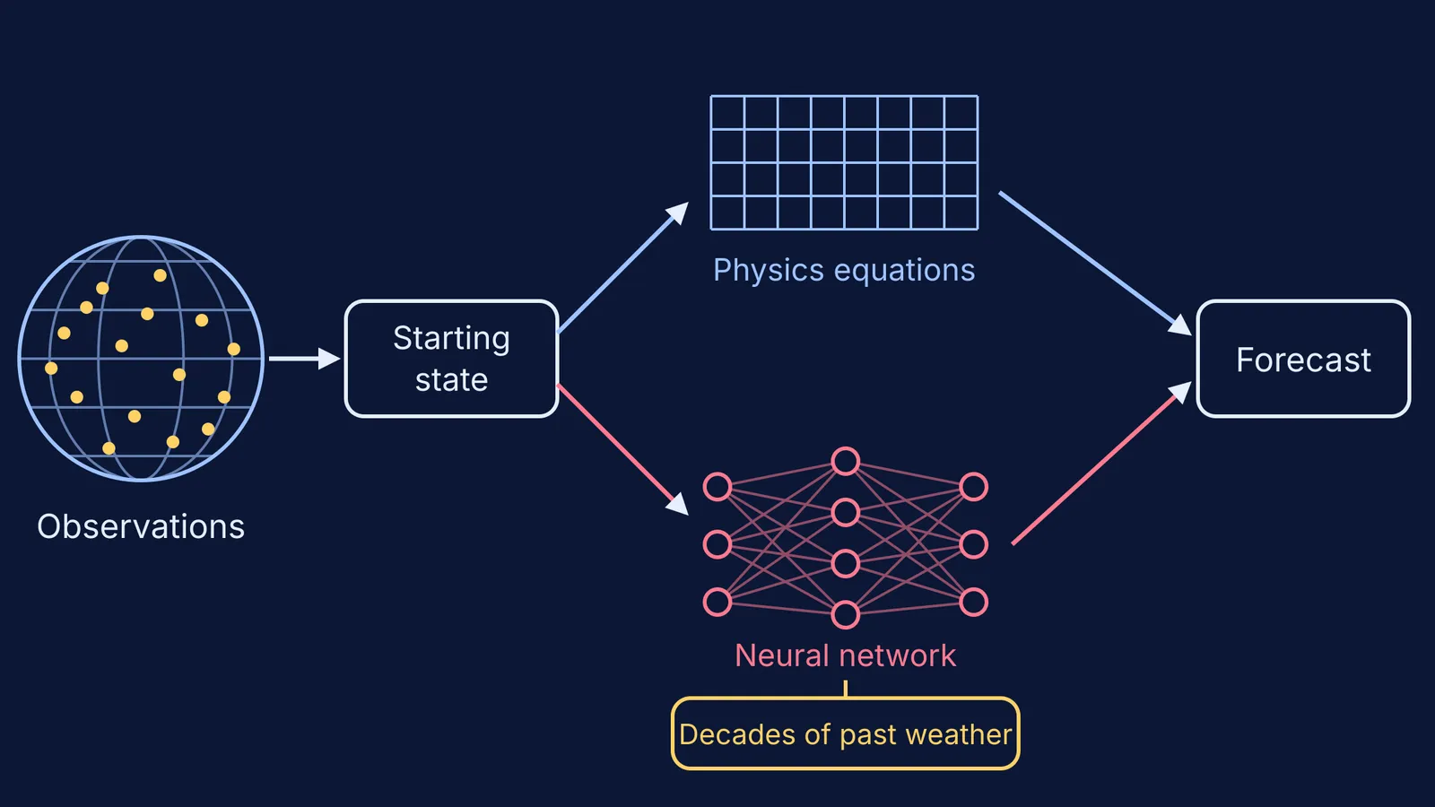
Traditional forecasting is called numerical weather prediction (NWP), and it relies on physics-based simulations of the atmosphere, as the GenCast paper in Nature puts it. The model divides the planet into grid boxes, works out how air, heat and moisture move between neighbouring boxes over a short time step, and repeats.
The physics is familiar from school: forces on moving air, conservation of mass and energy. The difficulty is scale. A 10-day forecast this way takes "hours of computation in a supercomputer with hundreds of machines", according to Google DeepMind. For the history, see our profile of Vilhelm Bjerknes and weather fronts.
How does AI predict the weather?
An AI weather model does not solve those equations. It learns from examples: the atmosphere at one moment, and what it looked like hours later. A trained neural network takes today's state, predicts the next step, then feeds its own output back in to go further. Like large language models, it predicts what comes next, but as numbers on a global grid rather than words.
The examples come from reanalysis. Reanalysis "combines model data with observations from across the world into a globally complete and consistent dataset using the laws of physics", says the Copernicus ERA5 page, and ERA5 covers weather from 1940 onwards. Google DeepMind's GraphCast was trained on four decades of ERA5 data (DeepMind).
The results:
GraphCast forecasts hundreds of variables 10 days ahead in under one minute, and beat the most accurate operational single forecast on 90% of 1,380 targets (Lam et al., Science, 2023).
GenCast produces a set of 15-day forecasts in 8 minutes and had greater skill than Europe's ensemble forecast, ENS, on 97.2% of 1,320 targets (Price et al., Nature, 2024).
The European Centre for Medium-Range Weather Forecasts (ECMWF) made its AI system, AIFS, operational on 25 February 2025, reporting gains of up to 20% on tropical cyclone tracks and about 1,000 times less energy per forecast (ECMWF).
ECMWF adds that AIFS starts from the same initial conditions as its physics model, built from around 60 million quality-controlled observations, and calls the two complementary.
Where do AI forecasts do well, and where do they struggle?
AI models do well on large-scale patterns days ahead: pressure systems, winds, temperature and storm tracks. GraphCast's authors report better tracking of tropical cyclones and extreme temperatures (Science). Speed also lets forecasters run many versions from slightly different starts, which is how they measure uncertainty.
They struggle where the past is a thin guide. A model has seen few examples of the rarest events, and one trained to keep its average error low tends to hedge, spreading a little rain everywhere instead of committing to one violent cloudburst.
Why are monsoon forecasts still hard?
The Indian summer monsoon is shaped by "complex interactions among the large-scale monsoonal circulation, mesoscale orographic systems (particularly the Western Ghats and the Himalayan foothills), organized convection, and ocean–atmosphere coupling", write the authors of a 2026 preprint evaluating GraphCast over India.
The preprint compared GraphCast's June to September forecasts for 2021-2024 with satellite rainfall data. GraphCast captured the broad pattern at short lead times, but was too wet on average over the core monsoon zone, its rainfall varied far less than the satellite record (a regional variance ratio of about 0.14), and it under-represented the most extreme events (arXiv preprint, not yet peer-reviewed).
In May 2026, Union Minister Jitendra Singh launched the IMD's AI-enabled forecast of monsoon advance, developed with IITM Pune and NCMRWF. It gives probabilistic forecasts of monsoon progress every Wednesday, up to four weeks ahead, for farmers in 16 states and more than 3,000 sub-districts (The Tribune). For the longer story, read our profile of Jagadish Shukla and monsoon prediction.
How should you read a monsoon forecast?
Many forecasts now come as ensembles: many runs that each show one possible future, like the set GenCast produces.
Read the probability, not the icon. Worked example: if 35 of 50 runs put rain over your town tomorrow, the forecast is 35 ÷ 50 = 70%. Three days in ten like it, you stay dry, and the forecast was still right.
Match the lead time to the question. Tomorrow's forecast can guide your afternoon; a week-three outlook tells you whether the monsoon has reached your region, not whether it rains at 4 pm.
For heavy rain, follow official IMD warnings, not an app's cloud icon, because AI guidance can understate extremes.
Test it yourself: for one week, note the morning forecast and what happened.
If grid boxes and time steps are hard to picture, the Fermi Simulation Lab has interactive simulations for ideas that are easier to see than to read. To work up from pressure and convection to how forecasts are built, Fermi's AI tutor works out what you already know and builds a plan for the session.