On this page
Chapter 1 of NCERT's Class 11 India: Physical Environment is short, but its numbers return in map work and in later chapters. Here are the key facts with sources, and a way to work out the time sums instead of memorising them.
What is India's location and extent in Class 11 geography?
Every figure in this section comes from the NCERT Class 11 chapter India – Location.
The mainland runs from Kashmir in the north to Kanniyakumari in the south, and from Arunachal Pradesh in the east to Gujarat in the west.
India's southern boundary extends to 6°45'N latitude in the Bay of Bengal.
India's latitudinal and longitudinal extents are each roughly 30 degrees.
The north-south distance is 3,214 km; the east-west distance is only 2,933 km.
India's area is 3.28 million sq. km, 2.4 per cent of the world's land surface, which makes it the seventh largest country.
The coastline is 6,100 km for the mainland and 7,517 km including the Andaman and Nicobar Islands and Lakshadweep.
Why is the east-west distance shorter when both extents are about 30 degrees? Because the distance between two longitudes shrinks towards the poles, while the distance between two latitudes stays the same. The latitude spread matters too: the south lies within the tropics and the north in the sub-tropical zone, which NCERT links to India's variety of landforms, climate, soils and vegetation.
Why is 82°30'E India's standard meridian?
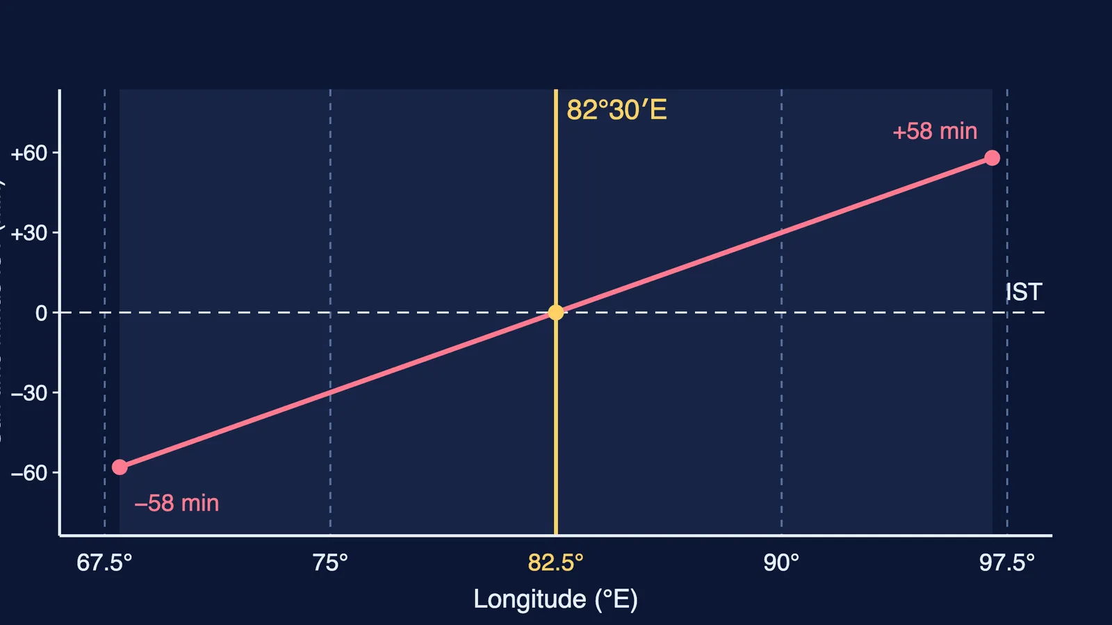
NCERT explains that countries generally choose a standard meridian in multiples of 7°30' of longitude, which is why 82°30'E was selected, and that Indian Standard Time is 5 hours 30 minutes ahead of Greenwich Mean Time (NCERT Class 11, Chapter 1). The same chapter notes that the sun rises in the northeastern states about two hours earlier than in Jaisalmer, yet clocks across the country show the same time. Our explainer on why Indian Standard Time is offset by half an hour covers how that half-hour came about.
Worked example: every time sum from one rule
The Earth turns 360 degrees in 24 hours, so each degree of longitude is worth 4 minutes of time.
IST offset: 82.5 × 4 = 330 minutes, which is 5 hours 30 minutes ahead of GMT.
East-west time gap: about 30 degrees × 4 = 120 minutes, the "nearly two hours" in the textbook (NCERT Class 11, Chapter 1).
Why 82°30'? 82.5 ÷ 7.5 = 11, a whole number, so it fits the 7°30' convention.
A place on 90°E: (90 − 82.5) × 4 = 30 minutes, so the sun is highest there at about 11:30 IST, not 12:00.
What are the six physiographic divisions of India?
The NCERT chapter Structure and Physiography defines physiography as the outcome of structure, process and the stage of development, and divides India into six divisions. The figures below are from that chapter.
The Northern and Northeastern Mountains. The Great Himalayan range is about 2,500 km long and 160-400 km wide.
The Northern Plain. Built from Indus, Ganga and Brahmaputra alluvium, it runs about 3,200 km east to west, with an average width of 150-300 km. From north to south: the Bhabar, the Tarai, then the older Bhangar and newer Khadar alluvium.
The Peninsular Plateau. It rises from 150 m above the river plains to 600-900 m and has three parts: the Deccan Plateau, the Central Highlands and the Northeastern Plateau. Anaimudi (2,695 m) is its highest peak.
The Indian Desert. Northwest of the Aravalis, it gets less than 150 mm of rain a year and is also called Marusthali.
The Coastal Plains. The western plain is narrow and submerged; the eastern plain is broader, emergent and has deltas.
The Islands. The Bay of Bengal group has about 572 islands and islets, including Barren Island, India's only active volcano; Lakshadweep has about 36 islands, 11 of them inhabited.
For two of these regions in depth, read how the Rann of Kutch salt desert formed and how plate tectonics shaped the Andaman Islands.
How should you revise India's location and physiography?
Try this three-day map drill, about 20 minutes a day, using the figures from NCERT Chapter 1 and Chapter 2.
Day 1: On a blank outline map, mark the Tropic of Cancer, 82°30'E and 6°45'N. Write the 3,214 km and 2,933 km pair with the one-line reason.
Day 2: Shade the six divisions from memory, check against Figure 2.2 in the NCERT chapter, and add one number to each.
Day 3: Answer the chapter's 30-word questions aloud: fact, number, reason.
A sample answer to the textbook's question on why watches in Kohima and New Delhi show the same time: "Both follow Indian Standard Time, fixed by the 82°30'E standard meridian. Local sun time changes with longitude, but one standard time keeps every clock in India the same."
If geography sits next to physics or maths in your timetable and you are not sure where to begin, Fermi's AI tutor can work out what you already know and build a plan for the session. Start with the Day 1 map tonight.