On this page
The Andaman and Nicobar Islands curve from Myanmar towards Sumatra because they trace the edge where one tectonic plate dives beneath another. On 26 December 2004 that edge produced one of the largest earthquakes since 1900, according to the US Geological Survey record of the event.
Why do the Andaman Islands have earthquakes?
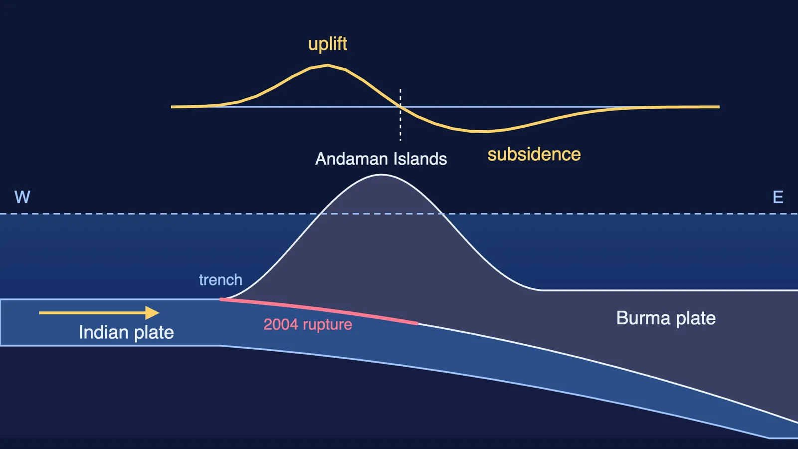
The islands sit on the boundary between the Indian plate and a small plate to the east, the Burma microplate. The USGS describes the 2004 earthquake as thrust faulting on the interface of the India plate and the Burma microplate (USGS event summary). The same summary says the India and Australia plates move north-northeast at about 60 mm per year relative to the Eurasia plate, meeting the trench at an angle.
A subduction zone is a plate boundary where one plate slides down beneath another into the mantle. Here the Indian plate starts its dive at a deep-sea trench west of the islands, and the islands ride on the upper plate, above the shallow part of the fault.
The plates do not slide smoothly. The shallow fault stays locked while the plates keep moving, so the upper plate bends and stores strain, like a ruler pushed at one end. When the fault slips, the strain is released in minutes. Deeper earthquakes follow the sinking plate away from the trench; how Kiyoo Wadati found that sloping zone of deep earthquakes is a story of its own.
What did the 2004 earthquake do to the islands?
The 2004 earthquake had a moment magnitude of 9.1 to 9.3 (Lay and colleagues, Science, 2005). Its rupture ran about 1,600 kilometres, from Sumatra to Myanmar (Meltzner and colleagues, JGR, 2006).
GPS surveys at 13 sites showed the Andaman and Nicobar Islands moved 1.5 to 6.5 metres towards the southwest, with vertical movement of 0.5 to 2.8 metres, mostly sinking, and the largest shifts in the Nicobars (Gahalaut and colleagues, 2006).
The islands also tilted. The northern and western Andaman Islands rose, the southern and eastern parts sank, and the Nicobar Islands subsided (Meltzner and colleagues). That is elastic rebound: the plate edge near the trench springs up and land behind it drops.
The USGS record counts more than 283,100 people killed by the earthquake and its tsunami (USGS event record).
How long did the 2004 slip take to build up?
The India plate moves at about 60 mm a year relative to Eurasia (USGS), and only part of that motion pushes straight across this fault. Under the Andamans the fault slipped 3.8 to 7.9 metres (Gahalaut and colleagues). Even storing all of it, that slip takes at least:
3.8 m ÷ 0.06 m per year, about 63 years
7.9 m ÷ 0.06 m per year, about 132 years
The real figure is longer: the USGS says the 2004 faulting released strains that had built up for centuries. So treat this as a rough lower bound, not a forecast. Why earthquakes cannot be predicted explains what scientists map instead.
How do tsunami warning buoys detect a tsunami?
India's tsunami warning network has 7 tsunami buoys, set up by INCOIS and the National Institute of Ocean Technology (NIOT), that send data by satellite to INCOIS in Hyderabad and NIOT in Chennai (INCOIS tsunami buoy page).
Each has a bottom pressure recorder on the seafloor, which measures the height of water above it, and a surface buoy that relays its data to a satellite. The recorder measures pressure every 15 seconds and predicts each next reading; if a reading misses the prediction by more than 30 mm, it switches to event mode and reports far more often.
How small a change can a tsunami buoy detect?
INCOIS says the buoys can detect a 1 cm change in water up to 6 km deep (INCOIS). Use pressure = density × g × depth, rounding seawater to 1,000 kg per cubic metre:
Pressure from 6 km of water: 1,000 × 9.8 × 6,000, about 59,000,000 Pa.
Extra pressure from 1 cm more water: 1,000 × 9.8 × 0.01, about 98 Pa.
Ratio: 98 ÷ 59,000,000, about 1 part in 600,000.
That is like noticing one extra rupee in ₹6 lakh. It works because tides change the reading slowly and predictably, while a tsunami changes it within minutes.
If pressure and depth feel slippery, the Fermi Problem Library has worked problems with a step-by-step solver that explains the reasoning, and the Fermi Simulation Lab has interactive simulations for ideas that are easier to see than to read.
How can you explain the Andaman earthquakes in one minute?
Use this chain in a class answer or a viva:
Boundary: the Indian plate slides under the Burma microplate at a trench.
Lock: the shallow fault sticks while the plates keep moving.
Store: the upper plate bends and stores strain.
Release: the fault slips; in 2004 it broke along about 1,600 km (Meltzner and colleagues).
Rebound: land near the trench rises, land behind sinks, and the moving seafloor lifts the water into a tsunami.
Near the source, a tsunami can arrive before any official warning, so learn the natural signs in why the sea pulls back before a tsunami, and what to do.