
On this page
Now and then a message goes round WhatsApp saying a big earthquake will hit a city on a certain date. Such claims have no scientific basis, and the reason is a useful bit of physics.
What would an earthquake prediction actually need?
According to the US Geological Survey (USGS), a real earthquake prediction has to give three things: the date and time, the location, and the magnitude. On that same page the USGS says plainly that neither it nor any other scientists have ever predicted a major earthquake.
What scientists can do is calculate the probability of a significant earthquake in an area within a certain number of years. The USGS likens these probabilities to climate statistics. Think of it this way: you can say a city gets heavy monsoon rain, but not name next year's wettest day.
Why can't scientists predict earthquakes?
The basic idea dates back to the 1906 San Francisco earthquake. Geologist Harry Fielding Reid proposed what is now called the elastic rebound theory: the crust slowly stores elastic stress and then releases it suddenly. Near Bolinas, a fence along the fault was offset by about 8.5 feet in 1906, according to the USGS.
Think of bending a ruler until it snaps. You know it will break, but not on which push, because that depends on tiny flaws you cannot see. In a fault, those flaws sit in rock deep underground that nobody can reach.
The push comes from moving plates. The USGS notes that India's continued movement still puts enormous pressure on Asia, and that the Himalayas are still rising by more than 1 cm a year.
In a 1997 paper in *Science* titled "Earthquakes cannot be predicted", Robert Geller and three co-authors argued that any small earthquake has some chance of cascading into a large one, and that the outcome depends on fine details inside the Earth that cannot be measured.
Ideas like elastic rebound are easier to see than to read about. The Fermi Simulation Lab has interactive simulations for the ideas that are easier to see than to read.
What happened when scientists tried?
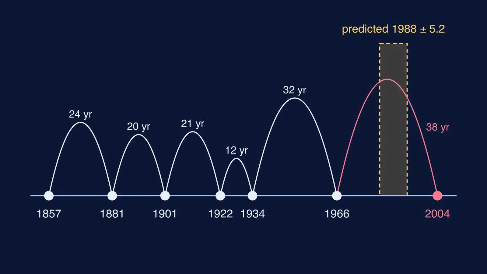
Parkfield, on California's San Andreas fault, looked like the easy case. Bakun and Lindh's 1985 analysis, published by the USGS, listed magnitude 6 earthquakes there in 1881, 1901, 1922, 1934 and 1966, plus one in 1857. They found a mean interval of 21.9 years and predicted the next one for 1988.0, give or take 5.2 years.
It arrived on 28 September 2004, more than ten years after the window closed, as a magnitude 6.0 earthquake recorded by the instruments put there to catch it. Bakun and colleagues reported in *Nature* in 2005 that the 2004 earthquake, with its lack of obvious precursors, showed that reliable short-term prediction is still not achievable.
What do experts map instead of dates?
They map risk. After the 2009 L'Aquila earthquake in Italy, an international commission led by Thomas Jordan reported in 2011 that the search for warning signs had not produced a successful short-term prediction scheme. It set out guidelines for probability-based forecasting and noted that long-term models guide building codes.
For example, using the UCERF3 model, the USGS gives the San Francisco Bay Area a 72% chance of a magnitude 6.7 or larger earthquake within 30 years.
India uses the same thinking in its seismic zones. In December 2022, Jitendra Singh, Minister of State for Earth Sciences, told the Lok Sabha that around 59% of India's land is prone to earthquakes, with about 11% in Zone V, the most active zone on the map then in use. The zone map is revised from time to time, so check the current Bureau of Indian Standards code before relying on a specific zone.
The National Center for Seismology has also pushed back on viral claims. In March 2025, it rejected an individual's forecast for Delhi and Nepal, saying earthquakes cannot be predicted by time and location.
How do you check an earthquake prediction you see online?
Ask four questions before you forward it:
Does it give a date, a place and a magnitude? If one is missing, it is not a prediction by the USGS definition.
Who made it: a seismology agency, or an anonymous forward?
Is it a probability over years, or a single date? Only the first is something scientists do.
Does it suggest something useful, or just spread panic?
Worked example. Take the Bay Area's 72% chance in 30 years from the USGS. Assume, as a rough simplification, that quakes arrive at a steady average rate. Then the chance of none in 30 years is 0.28, so the yearly rate is ln(1/0.28) / 30 ≈ 0.042. Divide by 365 and the chance on any one day is about 0.012%, or roughly 1 in 8,600. A high risk over decades still looks tiny on any single day, which is why preparing works better than trying to pick a date.
Next, look up your own city's seismic zone on the current BIS map.