On this page
You see IST (UTC+5:30) on flight tickets, phone settings and online exam timetables. Many countries sit a whole number of hours from Greenwich, so the extra half hour looks odd. It is not a quirk. It comes straight out of one longitude and one multiplication, and you can check it yourself in under a minute.
Why is IST 5 hours 30 minutes ahead of UTC?
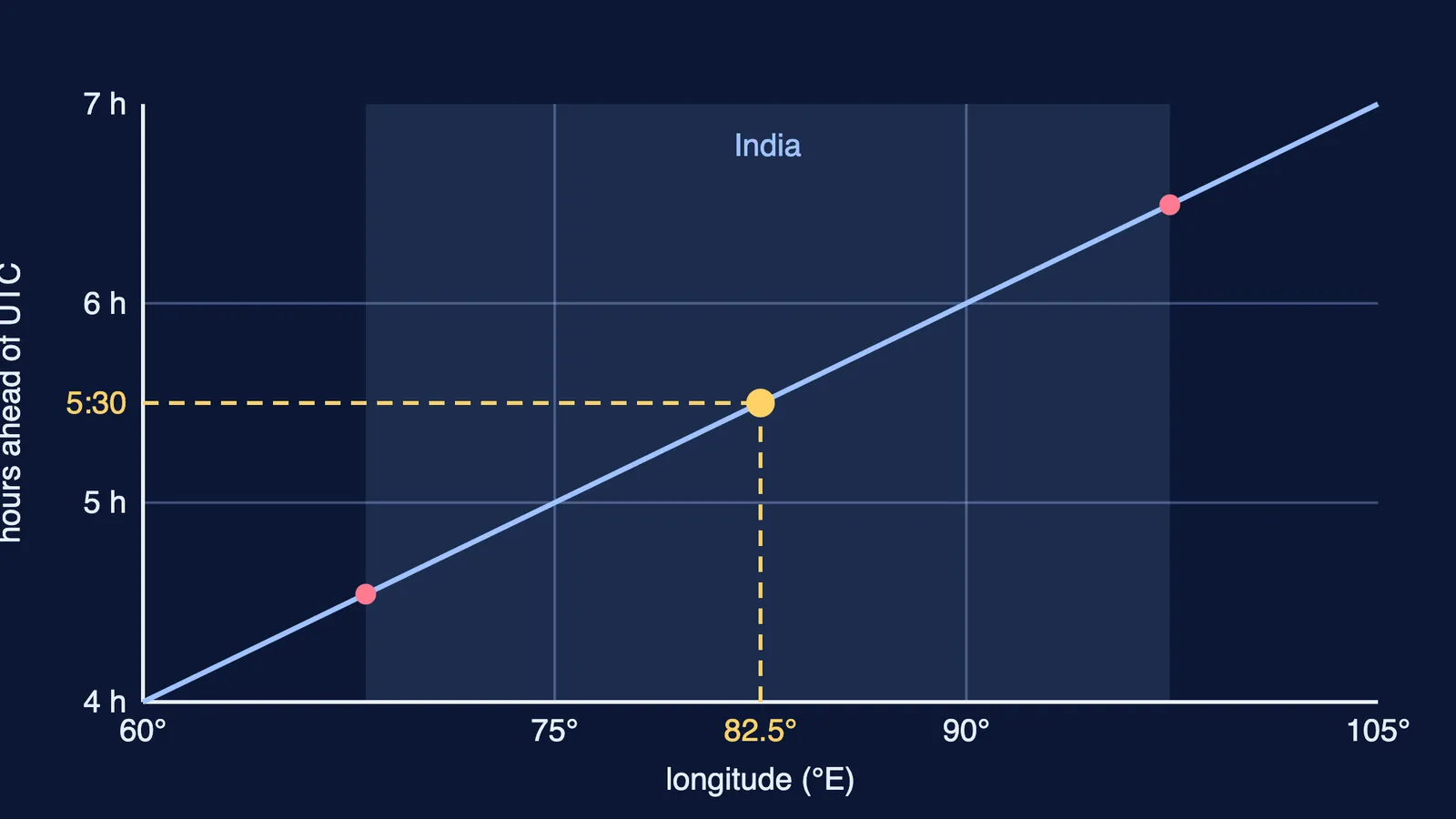
The Earth turns through 360° of longitude in 24 hours, so the Sun appears to cross 15° of longitude every hour, or 1° every 4 minutes, as NCERT's Class 11 chapter on latitude, longitude and time explains. Places east of Greenwich meet the Sun earlier, so their clocks run ahead.
Indian Standard Time is calculated from the 82°30′ E meridian passing through Mirzapur in Uttar Pradesh, according to the same NCERT chapter.
The sum takes three lines:
Write the longitude in degrees: 82°30′ = 82.5°, because 30 minutes of arc is half a degree.
Multiply by 4 minutes per degree: 82.5 × 4 = 330 minutes.
Convert to hours: 330 ÷ 60 = 5.5 hours, which is 5 hours 30 minutes.
So when it is 12:00 noon UTC, it is 5:30 p.m. in India.
Why 82.5° and not a round 80° or 85°?
NCERT notes that a country picks its standard meridian near its centre and divisible by 7°30′, so that its standard time differs from Greenwich by whole hours or half hours (NCERT, Practical Work in Geography). Every 7.5° is exactly 30 minutes, because 7.5 × 4 = 30.
Look at the three candidates near India:
75° E gives UTC+5:00 (75 × 4 = 300 minutes).
82.5° E gives UTC+5:30 (82.5 × 4 = 330 minutes).
90° E gives UTC+6:00 (90 × 4 = 360 minutes).
India extends from 68°7′ E to 97°25′ E, a spread of about 29°, according to a 2018 Current Science paper by CSIR-NPL scientists. The middle of that span is about 82.8° E, and 82.5° is the half-hour line closest to it. A whole-hour meridian at 75° or 90° would sit well off-centre.
How far is Sun time from IST across India?
One clock for a wide country means the Sun and the clock disagree at the edges. Here is the worked example, using the extent given in the Current Science paper:
Western edge, 68°7′ E: 82°30′ − 68°7′ = 14°23′, about 14.38°. Times 4 is about 57.5 minutes, so local Sun time there runs nearly an hour behind IST.
Eastern edge, 97°25′ E: 97°25′ − 82°30′ = 14°55′, about 14.92°. Times 4 is about 59.7 minutes, so Sun time there runs nearly an hour ahead of IST.
End to end: 29°18′, about 29.3°, times 4 is about 117 minutes, close to two hours.
That gap is why the Sun rises and sets early by the clock in the north-east. The same CSIR-NPL authors proposed two zones: IST-I at UTC+5:30 and IST-II at UTC+6:30 for regions east of 89°52′ E (Current Science, 2018). In August 2026 the government notified the Legal Metrology (Indian Standard Time) Rules, 2026, which it describes as a step towards establishing IST as the common, legally recognised and traceable time reference for the country, according to the Press Information Bureau.
Who keeps Indian Standard Time accurate?
The meridian fixes the offset; atomic clocks keep the seconds. CSIR-National Physical Laboratory maintains India's national atomic time scale and keeps IST traceable to UTC within a few nanoseconds, the PIB release says. The new Rules come into force 180 days after their Gazette publication on 29 August 2026, according to the same release.
Practise it: three quick sums
Try each one before reading the answer. All use the 4-minutes-per-degree rule from the NCERT chapter.
It is 9:00 a.m. UTC. What time is it in India? Answer: 9:00 + 5:30 = 2:30 p.m.
NCERT's own example puts Thimphu, Bhutan, at 90° E. How far is its local Sun time ahead of UTC, and of IST? Answer: 90 × 4 = 360 minutes, so 6 hours ahead of UTC and 30 minutes ahead of IST.
An online exam starts at 10:00 a.m. IST. What is that in UTC? Answer: subtract 5 hours 30 minutes to get 4:30 a.m. UTC.
The usual slip is the direction: east of Greenwich you add, west you subtract. If that keeps tripping you up, the Fermi Problem Library has worked problems with a step-by-step solver that explains the reasoning rather than printing an answer.
If borrowing across the hour is the hard part, our guide on how to calculate time differences with the 24-hour clock walks through it. Longitude gives you time; for latitude, see why the pole star does not move, and how it gives your latitude. The same 24-hour spin also sets the height of geostationary satellites.
To go further into rotation and angle measure, the Fermi Concept Library covers every concept in physics, chemistry, biology, mathematics and computing, each with its own lesson.