
On this page
Natural Vegetation is Chapter 5 of NCERT's Class 11 book India: Physical Environment (NCERT, Reprint 2026-27). The CBSE 2026-27 Geography curriculum keeps all of it: forest types, forest conservation, and wildlife with biosphere reserves. Climate and Natural Vegetation share 12 marks out of 35 for this book, with no separate figure for this chapter. Map work carries its own 5 marks.
What is natural vegetation?
NCERT defines natural vegetation as a plant community left undisturbed long enough for its species to adjust fully to the local climate and soil (NCERT, Chapter 5). A mango tree in an orchard is planted; the same tree growing wild in a forest is natural vegetation. As climate and soil change across India, so does the vegetation. If the relief regions are hazy, revise India's location and physiography first.
What are the five types of forests in India?
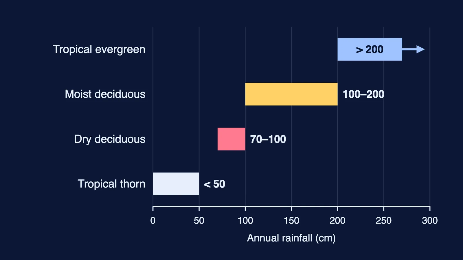
NCERT groups Indian forests into five types by main vegetation and climate (Chapter 5). For the first three, rainfall decides the type, as the chart shows.
Tropical evergreen and semi evergreen. Over 200 cm of rain and a mean annual temperature above 22°C. Western slope of the Western Ghats, the northeastern hills, the Andaman and Nicobar Islands. Layered, with trees up to 60 m or more and no fixed leaf-shedding season. Rosewood, mahogany, ebony.
Tropical deciduous, or monsoon forests. The most widespread type, with 70 to 200 cm. Moist deciduous (100 to 200 cm): Himalayan foothills in the northeastern states, eastern slopes of the Western Ghats, Odisha; teak, sal, sandalwood. Dry deciduous (70 to 100 cm): rainier parts of the Peninsula, plains of Uttar Pradesh and Bihar; tendu, palas, khair.
Tropical thorn. Under 50 cm. Semi-arid areas of Rajasthan, Gujarat, Haryana, south-west Punjab, Madhya Pradesh and Uttar Pradesh. Babool, ber, khejri.
Montane. Set by altitude. In the Himalayas, wet temperate forest grows at 1,000 to 2,000 m, blue pine and spruce at 2,225 to 3,048 m, and silver fir, birch and rhododendron at 3,000 to 4,000 m. In the Nilgiri, Anaimalai and Palani hills, temperate forests are called sholas.
Littoral and swamp. Wetlands and mangroves. India's mangroves cover 4,992 sq km, 7 per cent of the world's, best developed in the Sundarbans and the Andaman and Nicobar Islands. Chilika Lake and Keoladeo National Park are Ramsar Convention sites.
How does India conserve its forests?
India adopted a forest policy in 1952 and revised it in 1988 (NCERT, Chapter 5). Its first aim is 33 per cent of the geographical area under forest cover. Others include restoring ecological balance, checking soil erosion, meeting rural needs for fuel and fodder, and a people's movement, involving women, to plant trees and stop felling.
Social forestry means managing forests and planting barren land to support environmental, social and rural development. In 1976 the National Commission on Agriculture split it into urban forestry (parks, green belts, roadside trees), rural forestry (agro-forestry and community forestry) and farm forestry (farmers growing trees on their own land).
How is wildlife protected in India?
NCERT estimates that about 4 to 5 per cent of the world's known species of plants and animals live in India (Chapter 5). Clearing land, lopping for fuelwood, grazing, poaching and forest fires have cut their numbers.
Wildlife Act, 1972, amended in 1991: protects listed endangered species and backs national parks, sanctuaries and closed areas. India has 107 national parks and 573 wildlife sanctuaries.
Project Tiger, 1973: began with nine reserves; now 58 reserves with 84,487 sq km of core habitat in 18 states. The tiger count was 1,411 in 2006 and 3,682 in 2023, over 75 per cent of the world's tigers.
Project Elephant, 1992: supports states with free-ranging wild elephants, in 18 states.
Biosphere reserves: ecosystems recognised under UNESCO's Man and Biosphere Programme. India has 18, from Nilgiri (1986) to Panna (2011); 12 are on UNESCO's world network.
Which map items does CBSE ask from this chapter?
The 2026-27 curriculum lists these for the outline map of India:
Identify: tropical evergreen, tropical deciduous, tropical thorn, montane, and littoral or swamp forests.
National parks: Corbett, Kaziranga, Ranthambore, Shivpuri, Simlipal.
Bird sanctuaries: Keoladeo Ghana, Ranganathittu.
Wildlife sanctuaries: Periyar, Rajaji, Mudumalai, Dachigam.
That is 11 points to locate. Try a ten-minute drill: mark all 11 on a blank outline map from memory, check against your atlas, and redo only the misses the next day.
Practice questions
Which forest type grows where rainfall is 70 to 100 cm? (1 mark)
Compare moist and dry deciduous forests on rainfall, region and two species each. (3 marks)
A trekker climbs from 1,000 m to 3,500 m in the Himalayas. Describe the forests she passes. (3 marks)
How does social forestry help meet the aims of the 1988 forest policy? (5 marks)
For how climate types are classified worldwide, see world climate and climate change. If you are unsure where to start revising, Fermi's AI tutor can work out what you already know and build a plan for the session.