
On this page
Some July weeks Nagpur and Bhopal stay dry while rivers in Assam and north Bihar run high. That is usually a monsoon break, and you can spot one yourself on India Meteorological Department (IMD) maps.
What is a break in the monsoon?
IMD defines breaks as intervals of dry monsoon conditions when the large-scale rainfall over the monsoon trough zone is interrupted for several days in July and August (IMD Pune monsoon FAQ).
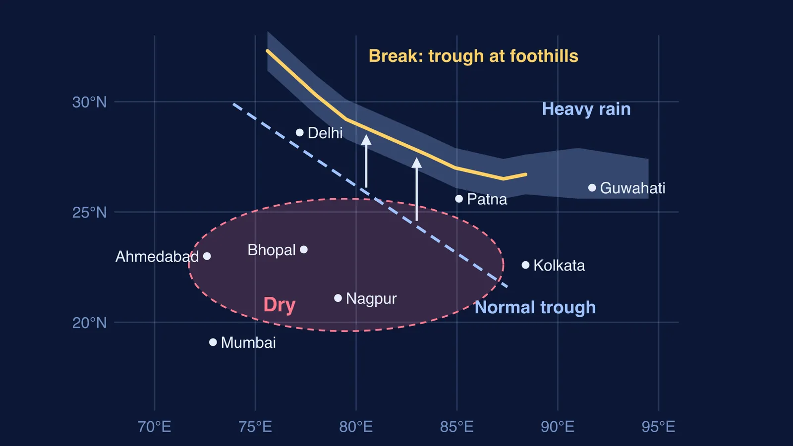
The monsoon trough is an elongated low-pressure area that stretches from the heat low over Pakistan to the head of the Bay of Bengal, according to the same IMD FAQ. Moist winds converge into this low, so where the trough lies, the rain tends to follow.
When the trough's eastern end swings south, the monsoon turns active; when it migrates north, break conditions set in over most of India and heavy rain falls along the Himalayan foothills, the FAQ explains.
Why does the monsoon trough shift to the Himalayan foothills?
IMD's 1969 forecasting manual on breaks, written by K. Ramamurthy, sets out the usual picture (IMD Forecasting Manual IV-18.3). The trough normally runs from Punjab to the head of the Bay of Bengal. Citing earlier work, the manual says it shifts north to the foothills when a monsoon depression has moved up to the Himalayas and broken up there. When there is no low in the Bay, a western disturbance crossing the far north can also drag the trough to the foot of the hills.
During breaks, the manual found the largest pressure rises, about 2 to 3 millibars above normal, over Gujarat, Madhya Pradesh, Odisha and the nearby Bay. The pressure gradient that drives the monsoon winds goes slack: between Dahanu and Thiruvananthapuram the difference averaged only about 3 millibars during breaks, the same manual reports.
The rain that results is lopsided:
heavy rain along the Himalayas, heaviest in the east: north Assam, sub-Himalayan West Bengal and north Bihar
rain continues on the west coast, but weaker
more thunderstorm rain in the southeastern peninsula
rain almost stops over the rest of India, especially the central parts
For the pressure-gradient basics, see what makes the Indian monsoon winds blow.
How long does a break in the monsoon last?
Ramamurthy catalogued July and August breaks from 1888 to 1967, leaving out lulls of only one or two days. He found 113, lasting from 3 to 21 days (IMD Forecasting Manual IV-18.3). The longest ran 21 days, from 29 July to 18 August 1906. In July, 52% of breaks lasted only 3 to 4 days. In 12 of those 80 years there was no break at all in July or August.
Why the rain band pulses north and south is its own story: Sulochana Gadgil and the rain band that pulses north over India.
How do you read a monsoon break on IMD rainfall maps?
IMD's rainfall information page has daily, weekly, monthly and cumulative maps for districts, states and sub-divisions, each area coloured by its departure from normal. IMD's categories, from its monsoon FAQ, are:
Large excess: 60% or more above normal
Excess: 20% to 59% above normal
Normal: within 19% of normal either way
Deficient: 20% to 59% below normal
Large deficient: 60% to 99% below normal
For the millimetre figures, see what 100 mm of rainfall actually means. Then run this four-step check:
Open the daily or weekly sub-division map, not the cumulative one.
Look at the middle band: Gujarat, Madhya Pradesh, Vidarbha, Chhattisgarh and Odisha. In a break these usually turn deficient or large deficient.
Look at the top edge: Uttarakhand, east Uttar Pradesh, Bihar, sub-Himalayan West Bengal and Sikkim, Assam and Meghalaya. In a break these often show normal or above-normal rain.
Check the Weather Systems line of the IMD bulletin: is the monsoon trough close to the foothills, and has it stayed there more than two days?
What did a real monsoon break look like in 2021?
IMD's press release of 10 August 2021 reported that the eastern end of the monsoon trough had shifted close to the Himalayan foothills (IMD press release, 10 August 2021). It expected weak monsoon conditions to last 5 to 6 more days everywhere except northeast and adjoining east India and northern Uttar Pradesh and Bihar. The three heaviest falls that morning were Mawsynram (25 cm), Cherrapunji (22 cm) and Nainital (18 cm), and subdued rain was forecast for northwest India's plains, adjoining central India and most of the peninsula. Trough at the foothills, wet northern edge, drying middle: the break pattern described above.
One day can still mislead: the same release lists 15 to 17 cm at Bhind, Damoh and Panna in Madhya Pradesh, so check the weekly map too.
To practise drawing this before an exam, Fermi's AI tutor can draw the figure with you and check your understanding as it goes, so you can explain the trough's shift in your own words.
Next time your city goes dry in late July, open the daily map and look north before you blame the forecast.