On this page
On a world map, the Atlantic coasts of South America and Africa seem to fit like torn paper. Chapter 4 of NCERT's Class 11 *Fundamentals of Physical Geography* explains why. Continents cover 29 per cent of the Earth's surface and the rest lies under the oceans, according to the NCERT chapter on the distribution of oceans and continents.
What did Wegener's continental drift theory say?
Alfred Wegener, a German meteorologist, put forward his continental drift theory in 1912, according to the NCERT chapter. He was not the first to notice the fit: Abraham Ortelius, a Dutch map maker, proposed as early as 1596 that the Americas, Europe and Africa were once joined.
Wegener said the continents once formed one supercontinent, Pangaea ("all earth"), inside one ocean, Panthalassa ("all water"). Around 200 million years ago Pangaea began to split into Laurasia in the north and Gondwanaland in the south.
His weak point was the force. He blamed a pole-fleeing force from the Earth's rotation and a tidal force from the Moon and the Sun. Most scholars thought these forces totally inadequate.
What evidence supports continental drift?
The NCERT chapter gives five lines of evidence. Remember them as J-R-T-P-F, one fact each:
Jig-saw fit: in 1964 Bullard's computer fit matched the Atlantic margins at the 1,000-fathom line.
Rocks of the same age: 2,000-million-year-old rocks on the Brazil coast match those of western Africa.
Tillite: India's Gondwana sediments, with glacial tillite at their base, have counterparts in six Southern Hemisphere landmasses.
Placer deposits: gold on the Ghana coast has no local source rock; the gold-bearing veins are in Brazil.
Fossils: Mesosaurus skeletons occur only in South Africa and Brazil, now 4,800 km apart; lemurs live in India, Madagascar and Africa.
Worked example: how fast did the Atlantic open?
Take the two Mesosaurus sites, 4,800 km apart, and Pangaea's break-up about 200 million years ago (both figures from NCERT). Convert 4,800 km to 480,000,000 cm and divide by 200,000,000 years: about 2.4 cm a year. It assumes steady drift from the start of the break-up, so treat it as a rough check: centimetres a year, the same scale as the ridge rates NCERT quotes.
How did sea floor spreading change the picture?
In the 1930s Arthur Holmes suggested convection currents in the mantle, driven by heat from radioactive elements. After the Second World War, ocean floor mapping and palaeomagnetic studies found five facts, listed in the NCERT chapter:
Volcanic eruptions are common all along the mid-oceanic ridges.
Rocks at equal distances on either side of a ridge crest match in age, chemistry and magnetism; the youngest sit nearest the crest.
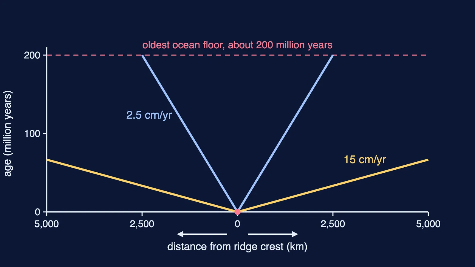
Ocean crust is nowhere more than 200 million years old; some continental rocks are 3,200 million years old.
Sediments on the ocean floor are unexpectedly thin.
Trenches have deep earthquakes; ridges have shallow ones.
From these, Hess (1961) proposed sea floor spreading: lava erupting at the crest pushes the ocean crust outwards on both sides, and old floor sinks at the trenches and is consumed. In 1963 F. J. Vine and D. H. Matthews published "Magnetic Anomalies Over Oceanic Ridges" in Nature. For the deep earthquakes under trenches, read how Kiyoo Wadati found the sloping zone of deep earthquakes.
What is plate tectonics, and how fast do plates move?
In 1967 McKenzie and Parker, and independently Morgan, combined these ideas into plate tectonics, according to the NCERT chapter. A tectonic plate is a massive, irregularly shaped slab of solid rock that moves horizontally over the asthenosphere. There are seven major plates: Antarctica, North American, South American, Pacific, India-Australia-New Zealand, Africa and Eurasia.
The key correction to Wegener: the plates move, carrying the continents. Plates meet at three kinds of boundary: divergent (the Mid-Atlantic Ridge), convergent (one plate dives under another at a subduction zone) and transform (plates slide past each other).
Stripes of normal and reverse magnetism parallel to the ridges let scientists measure the speeds. The Arctic Ridge spreads at less than 2.5 cm a year and the East Pacific Rise at more than 15 cm a year. India shows the result: it began its northward journey about 200 million years ago, the Deccan Traps began erupting around 60 million years ago, and it hit Asia 40 to 50 million years ago, raising the Himalayas. For the landforms this left, read India's location and physiography for Class 11; for an active plate edge, why the Andaman Islands have earthquakes.
How do you answer the 150-word questions?
Use this plan for NCERT's three long questions:
Evidence: write J-R-T-P-F as five points, one fact each.
Drift vs plate tectonics: compare what moves (continents vs plates), the force (pole-fleeing and tidal vs mantle convection), the evidence (mostly land vs ocean floor) and the date (1912 vs 1967).
Post-drift discoveries: the five ocean-floor facts, then Hess's idea in one line.
If you are not sure where to start revising, Fermi's AI tutor works out what you already know and builds a plan for the session.