
On this page
Planning and Sustainable Development in Indian Context is Chapter 6 of NCERT's Class 12 book India: People and Economy (NCERT, Reprint 2026-27). The CBSE 2026-27 Geography curriculum keeps the whole chapter: target area planning, sustainable development and the Bharmaur and Indira Gandhi Canal case studies. Unit III (Chapters 3 to 6) carries 10 marks together, with no separate figure for this chapter.
What is the difference between sectoral and regional planning?
NCERT treats planning as designing and carrying out actions towards a development goal (NCERT, Chapter 6).
Sectoral planning: schemes for sectors such as agriculture, irrigation, power and transport.
Regional planning: plans that reduce the gap between regions, because development is never even across space.
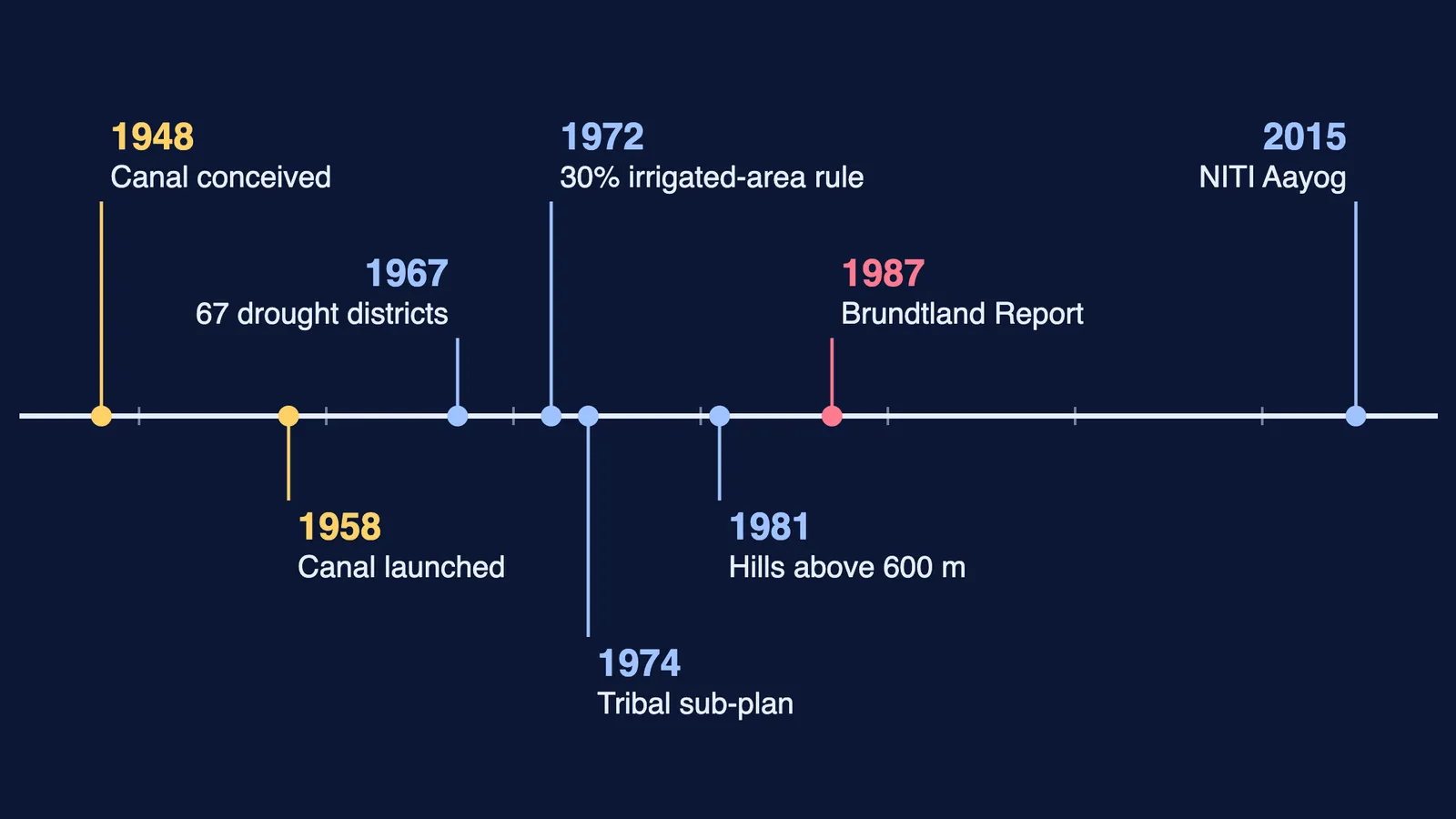
India moved from centralised to multi-level planning. The NITI Aayog replaced the Planning Commission on 1 January 2015.
What is target area planning?
As regional gaps widened, the Planning Commission brought in target area and target group approaches (NCERT, Chapter 6). Target area examples include Command Area Development, Drought Prone Area, Desert Development and Hill Area Development programmes; the Small and Marginal Farmers Development Agencies are target group examples.
Hill Area Development Programme
Started in the Fifth Five Year Plan in 15 hill districts, including present Uttarakhand, Darjeeling and Nilgiri.
In 1981 a national committee on backward areas recommended that hill areas above 600 m, if not under the tribal sub-plan, count as backward.
Aim: use local resources through horticulture, plantation, animal husbandry, forestry and village industry.
Drought Prone Area Programme
Started in the Fourth Five Year Plan to create jobs and productive assets.
It shifted from labour-intensive civil works to irrigation, land development, afforestation and rural infrastructure.
The Planning Commission (1967) identified 67 districts as drought-prone; the Irrigation Commission (1972) used a 30 per cent irrigated-area criterion.
NCERT suggests micro-level watershed development and jobs outside farming.
What happened in the Bharmaur tribal region?
Bharmaur, in Chamba district of Himachal Pradesh, is home to the Gaddis, traditionally transhumant herders (NCERT, Chapter 6). It was notified as a tribal area on 21 November 1975 and lies mostly between 1,500 m and 3,700 m. The Ravi and its tributaries divide it into Holi, Khani, Kugti and Tundah areas.
Under the 1974 tribal sub-plan, Bharmaur became one of five Integrated Tribal Development Projects (ITDP) in the state.
Female literacy: 1.88 per cent (1971), 65 per cent (2011). Sex ratio improved and child marriage declined.
Villages along the Ravi in Holi and Khani gained most from new infrastructure; remote Tundah and Kugti still lack it.
Only about one-tenth of households still practise transhumance.
What is sustainable development?
NCERT traces development from GNP growth, to growth with equity in the 1970s, to wider well-being by the 1980s (NCERT, Chapter 6). The Brundtland Report, Our Common Future (1987), defined sustainable development as meeting today's needs while leaving future generations able to meet their own. Our human development guide covers related ideas.
How did the Indira Gandhi Canal change the Thar Desert?
The canal (formerly Rajasthan Canal) was conceived by Kanwar Sain in 1948 and launched on 31 March 1958 (NCERT, Chapter 6). It starts at Harike barrage in Punjab; its planned length is 9,060 km and its culturable command area 19.63 lakh hectares, about 70 per cent planned for flow irrigation.
Worked example: Stage-I (Ganganagar, Hanumangarh, northern Bikaner) has 5.53 lakh hectares; Stage-II (six desert districts) has 14.10 lakh hectares. 5.53 + 14.10 = 19.63, so Stage-II is about 72 per cent of the command area, where NCERT calls the environment fragile.
Positive: soil moisture, greening, less wind erosion; wheat, cotton, groundnut and rice replaced gram, bajra and jowar.
Negative: waterlogging and soil salinity from heavy irrigation.
NCERT lists seven measures, five ecological: enforce water policy, avoid water-intensive crops (grow citrus), line water courses and use warabandi, reclaim waterlogged land, and plant shelterbelts and pastures. The other two: support for poor allottees, and diversifying beyond farming. Waterlogging also appears in our guide to geographical issues and problems.
How should you practise this chapter for the board exam?
The 2026-27 sample paper has 1-mark MCQs, 3-mark answers of 80 to 100 words and 5-mark answers of 120 to 150 words. Its Question 28 offers a choice between the canal and Bharmaur, and the marking scheme answers each with five points. Practise with questions we wrote:
(1 mark) Which commission used a 30 per cent irrigated-area criterion for drought-prone areas?
(3 marks) Why did planners move from sectoral to target area planning?
(3 marks) Why have Holi and Khani gained more from the ITDP than Kugti and Tundah?
(5 marks) Explain how one canal brought both greening and land degradation to western Rajasthan.
Cropping patterns link to our land resources and agriculture guide.
If you do not know where to start, Fermi's AI tutor can work out what you already know and build a plan for the session.