
On this page
Land Resources and Agriculture is Chapter 3 of NCERT's Class 12 book India: People and Economy (NCERT, Reprint 2026-27). In the CBSE 2026-27 Geography curriculum, Unit III (Chapters 3 to 6) carries 10 marks together, with no separate figure for this chapter. Map work adds the leading states for rice, wheat, cotton, jute, sugarcane, tea and coffee.
What are the land-use categories in Class 12 geography?
Land revenue records sort land into nine categories that add up to the reporting area, which can differ slightly from the Survey of India's geographical area (NCERT, Chapter 3):
Forests: land demarcated for forest, not actual tree cover.
Barren and wastelands: deserts, ravines, barren hills.
Land put to non-agricultural uses: settlements, roads, canals, industries.
Permanent pastures and grazing lands, mostly panchayat or government land.
Miscellaneous tree crops and groves.
Culturable wasteland: uncultivated for more than five years.
Current fallow: uncultivated for one agricultural year or less.
Fallow other than current fallow: more than one year, less than five.
Net area sown.
Fallow is a ladder: up to 1 year, 1 to 5 years, over 5 years. NCERT notes that between 1950-51 and 2019-20 five categories rose and four fell, with non-agricultural uses rising at the highest rate. The rise in forest share reflects more demarcated area, not more forest cover.
How do you calculate cultivable land and cropping intensity?
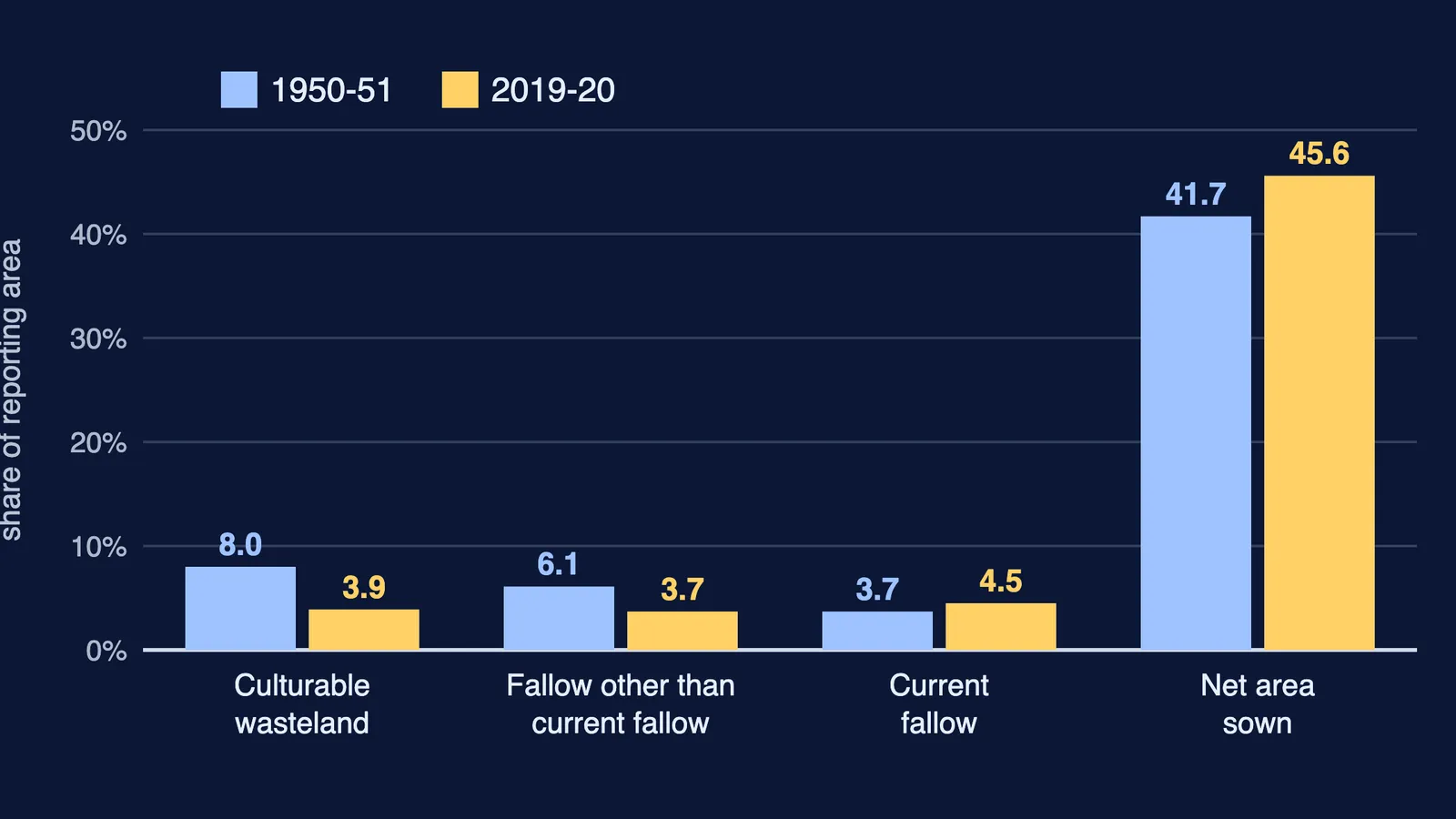
Total cultivable land is net sown area plus all fallow lands plus culturable wasteland (NCERT, Table 3.1). It fell from 59.5 per cent of reporting area in 1950-51 to 57.7 per cent in 2019-20, while net area sown rose from 41.7 to 45.6 per cent.
Worked example, NCERT's simple growth rate:
Net area sown: (45.6 − 41.7) ÷ 41.7 × 100 = 9.4 per cent rise in share.
Culturable wasteland: (3.9 − 8.0) ÷ 8.0 × 100 = −51.25 per cent, roughly halved.
Cropping intensity = gross cropped area ÷ net sown area × 100. On a made-up farm with 10 hectares sown in kharif and 6 of them sown again in rabi, gross cropped area is 16 hectares and cropping intensity is 160 per cent. NCERT says high cropping intensity suits India because it also creates rural work.
What are kharif, rabi and zaid crops?
NCERT's Table 3.2 gives three seasons for northern and interior India (NCERT, Chapter 3):
Kharif (June to September, southwest monsoon): rice, cotton, bajra, maize, jowar, tur.
Rabi (October to March): wheat, gram, rapeseed and mustard, barley.
Zaid (April to June, irrigated land): vegetables, fruits, fodder.
In southern India the same crop can be grown three times a year if soil moisture allows.
Which states lead in rice, wheat, cotton, jute, sugarcane, tea and coffee?
Map items, from the NCERT chapter:
Rice: West Bengal, Uttar Pradesh, Punjab. India produced 22.07 per cent of world rice in 2018, second after China.
Wheat: Uttar Pradesh, Madhya Pradesh, Punjab, Haryana, Rajasthan.
Cotton: Gujarat, Maharashtra, Telangana.
Jute: West Bengal (about three-fourths of output), then Bihar and Assam.
Sugarcane: Uttar Pradesh (about two-fifths), then Maharashtra, Karnataka, Tamil Nadu, Andhra Pradesh.
Tea: Assam (more than half), then West Bengal and Tamil Nadu.
Coffee: Karnataka (more than two-thirds), also Kerala and Tamil Nadu.
The curriculum's crop list also includes rubber, but the Reprint 2026-27 chapter has no rubber section and rubber is not a map item; check with your teacher.
What are the problems of Indian agriculture?
NCERT's list, from physical to institutional (NCERT, Chapter 3):
Erratic monsoon: only about 33 per cent of cultivated area is irrigated.
Low yields per hectare and per worker.
Costly inputs pushing small farmers into debt.
Land reforms not implemented effectively.
Small, fragmented holdings.
Lack of commercialisation.
Seasonal unemployment of 4 to 8 months in unirrigated tracts.
Land degradation: salinisation, alkalisation, waterlogging.
For a 5-mark answer, add that high yielding varieties of wheat (Mexico) and rice (Philippines) arrived by the mid-1960s, and the Green Revolution first spread in irrigated areas, creating regional disparities. Farm credit is in our rural development guide.
How should you practise this chapter for the board exam?
The 2026-27 sample paper has 1-mark MCQs, 3-mark answers of 80 to 100 words, 5-mark answers of 120 to 150 words and two map questions, including a land-use MCQ and the leading sugarcane state.
One catch: Q11 asks which category rose at the highest rate. The marking scheme keys "Forest", but NCERT's text names non-agricultural uses; ask your teacher which answer to give.
Try these questions we wrote:
(1 mark) Land unsown for three years falls in which category?
(3 marks) Why can the share of land classified as forest rise without more forest cover?
(3 marks) Distinguish protective from productive irrigation.
(5 marks) Using Table 3.1, explain why India has little room to expand net sown area.
(Map) Mark the leading states for jute and coffee.
See also our Class 12 guides to human development and international trade.
If you are not sure where to start, Fermi's AI tutor can work out what you already know and build a plan for the session.