On this page
International trade is the exchange of goods and services among countries across national boundaries, according to the NCERT Class 12 textbook Fundamentals of Human Geography, Chapter 8. Its own exercises ask you to name and explain its lists. Here are its four big ideas, a worked example and a revision checklist.
What is the basis of international trade?
The textbook says international trade is based on the principle of comparative advantage, complementarity and transferability of goods and services, and should in principle benefit both partners (NCERT, Chapter 8). It then lists five bases. Learn the heading and one example for each:
Difference in national resources: geological structure, mineral resources and climate differ, so wool comes from cold regions and bananas, rubber and cocoa from tropical ones.
Population factors: culture (Chinese porcelain, Iranian carpets) and size. Densely populated countries consume most of their output at home, so external trade is small.
Stage of economic development: agricultural countries swap farm products for manufactured goods; industrialised nations export machinery.
Extent of foreign investment: investment in mining, oil drilling or plantations in developing countries raises trade volume.
Transport: once only gems, silk and spices travelled far; modern transport and refrigeration widened trade.
What is balance of trade, and when is it unfavourable?
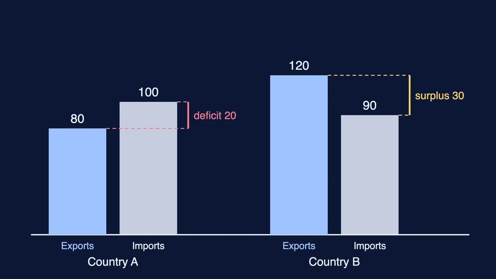
NCERT defines balance of trade as the record of the volume of goods and services imported and exported by a country (NCERT, Chapter 8). If imports are worth more than exports, the balance is negative or unfavourable; if exports are worth more, it is positive or favourable. The textbook warns that a negative balance, spending more on buying goods than is earned by selling them, would ultimately exhaust a country's financial reserves.
A worked example with made-up numbers:
Country A exports 80 units and imports 100. Balance of trade = 80 − 100 = −20, a deficit: unfavourable.
Country B exports 120 units and imports 90. Balance of trade = 120 − 90 = +30, a surplus: favourable.
Always write the formula, the sign, and the word favourable or unfavourable. If you take economics too, our explainer on balance of payments and exchange rates for Class 12 shows where the trade balance sits inside the wider account.
What does the WTO do?
According to NCERT, the General Agreement on Tariffs and Trade (GATT) was formed in 1948 to free the world from high customs tariffs and other restrictions, and it was transformed into the World Trade Organisation from 1 January 1995. The WTO sets the rules for the global trading system and resolves disputes between members; it also covers services such as banking. The textbook notes that the WTO is headquartered in Geneva, had 166 members as on December 2024, and counts India as a founder member. For the current list, check the WTO's own members and observers page.
For a long answer, add the criticism the chapter records: critics argue free trade widens the gap between rich and poor, and developed countries have not fully opened their markets. Link this to dumping, which NCERT defines as selling a commodity in two countries at a price that differs for reasons not related to costs. India's own opening-up is covered in our post on liberalisation, privatisation and globalisation since 1991.
What are the types of ports in Class 12 geography?
Ports are the chief gateways of international trade, and the quantity of cargo a port handles indicates how developed its hinterland is (NCERT, Chapter 8). The chapter classifies them three ways.
By cargo handled:
Industrial ports: bulk cargo such as grain, sugar, ore and oil.
Commercial ports: general cargo and passengers.
Comprehensive ports: bulk and general cargo in large volumes, like most great ports.
By location:
Inland ports: linked to the sea by river or canal, such as Kolkata on the Hooghly.
Out ports: deep-water ports serving a parent port that large ships cannot reach, such as Piraeus for Athens.
By specialised function:
Oil ports: tanker ports such as Maracaibo, refinery ports such as Abadan.
Ports of call: ports that grew as refuelling and supply stops on main sea routes, such as Aden, Honolulu and Singapore.
Packet stations (ferry ports): paired passenger and mail ports, such as Dover and Calais.
Entrepot ports: collection centres for export, such as Singapore and Rotterdam.
Naval ports: strategic ports such as Kochi and Karwar.
How should you revise this chapter?
Write the five bases of trade from memory, one example each.
Solve one balance of trade sum, with the sign.
State three WTO facts: GATT 1948, WTO from 1 January 1995, Geneva.
Fill three columns of port types with two examples each. Singapore is both a port of call and an entrepot, so say which role you mean.
Mark Singapore, Rotterdam, Piraeus, Aden and Kolkata on an outline map; see our Class 10 geography map work guide.
If physics or maths for the same boards is where you do not know where to start, Fermi's AI tutor can work out what you already know and build a plan for the session.