
On this page
Map work is the most predictable part of the Class 10 Social Science paper: the places are announced in advance, and the marks are yours if you can put a dot in the right place and name it.
How many marks is map work in Class 10 Social Science?
Map pointing carries 5 of the 80 marks in the theory paper, according to the CBSE Class 10 Social Science curriculum for 2026-27. Geography has 17 marks of theory plus 3 for map pointing; history has 18 plus 2. The CBSE sample question paper for 2025-26 put both on one outline map of India: Q9 for history and Q19 for geography.
For the chapter Lifelines of National Economy, the curriculum says only map pointing is evaluated in the board exam, so its ports and airports are pure memory marks.
Which geography map items does CBSE list?
The curriculum's map-work table lists these for geography (history adds three Congress sessions, three satyagrahas, Jallianwala Bagh and the Dandi March):
Resources and Development: identify major soil types.
Water Resources: locate and label Salal, Bhakra Nangal, Tehri, Rana Pratap Sagar, Sardar Sarovar, Hirakud, Nagarjun Sagar and Tungabhadra.
Agriculture: identify major areas of rice and wheat, and the major producer states of sugarcane, tea, coffee, rubber, cotton and jute.
Minerals and Energy: identify iron ore mines (Mayurbhanj, Durg, Bailadila, Bellary, Kudremukh), coal mines (Raniganj, Bokaro, Talcher, Neyveli) and oil fields (Digboi, Naharkatia, Mumbai High, Bassien, Kalol, Ankaleshwar); locate and label thermal plants (Namrup, Singrauli, Ramagundam) and nuclear plants (Narora, Kakrapara, Tarapur, Kalpakkam).
Manufacturing Industries: locate and label cotton textile centres (Mumbai, Indore, Surat, Kanpur, Coimbatore), iron and steel plants (Durgapur, Bokaro, Jamshedpur, Bhilai, Vijayanagar, Salem) and software technology parks (Noida, Gandhinagar, Mumbai, Pune, Hyderabad, Bengaluru, Chennai, Thiruvananthapuram).
Lifelines of National Economy: locate and label the sea ports (Kandla, Mumbai, Marmagao, New Mangalore, Kochi, Tuticorin, Chennai, Visakhapatnam, Paradip, Haldia) and international airports (Amritsar, Delhi, Mumbai, Chennai, Kolkata, Hyderabad).
A note under the table says locate-and-label items may also be given for identification, so learn every item both ways. Lists can change between sessions; check the current PDF at the start of your year.
How do you memorise map items by region?
The syllabus groups places by chapter, but the paper asks by place. Sample-paper Q19 asked for a dam by river basin (Sutlej-Beas or Mahanadi), plus any two of a West Bengal sea port, a Tamil Nadu airport and a Punjab airport; the official marking scheme gives Bhakra Nangal or Hirakud, Haldia, Chennai and Amritsar. Every clue pointed to a region.
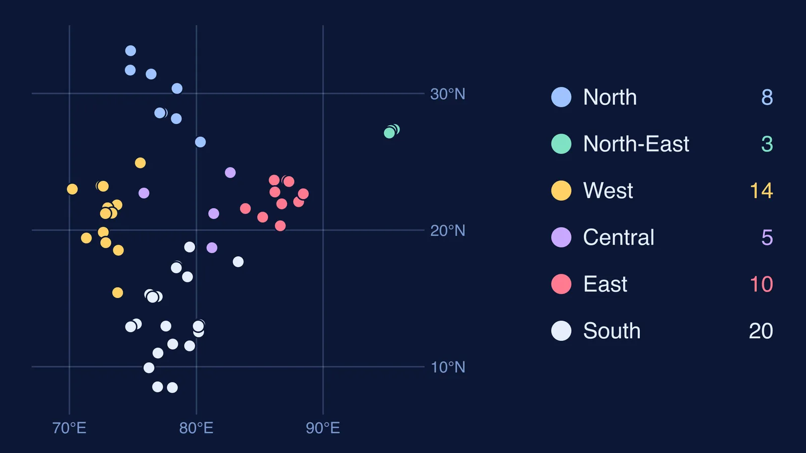
So re-sort the list into six regional "trips" across the map:
North: Salal, Bhakra Nangal, Tehri, Narora, Kanpur, Noida, Amritsar and Delhi airports.
North-East: Digboi, Naharkatia and Namrup, clustered in upper Assam.
West: Rana Pratap Sagar, Kandla, Kalol, Gandhinagar, Sardar Sarovar, Ankaleshwar, Surat, Kakrapara, Tarapur, Mumbai High, Mumbai, Pune, Marmagao.
Central: Indore, Singrauli, Durg, Bhilai, Bailadila.
East: Hirakud, Talcher, Paradip, Mayurbhanj, Jamshedpur, Bokaro, Raniganj, Durgapur, Haldia, Kolkata airport.
South: Hyderabad, Ramagundam, Nagarjun Sagar, Visakhapatnam, Bellary, Vijayanagar, Tungabhadra, Kudremukh, New Mangalore, Bengaluru, Chennai, Kalpakkam, Neyveli, Salem, Coimbatore, Kochi, Thiruvananthapuram, Tuticorin.
Walk each trip in the same order every time so the sequence becomes the memory. Pairs help: Durg (iron ore) sits beside Bhilai (steel), Raniganj (coal) beside Durgapur (steel).
What does a weekly blank-map routine look like?
In two experiments by Roediger and Karpicke, students who practised recall remembered more after two days and a week than students who restudied. A review of ten study techniques by Dunlosky and colleagues rated practice testing and spaced practice as high utility, and rereading as low. The studies used prose, not maps, but a labelled atlas is rereading; a blank map is a test.
Print a stack of outline maps and give it 15 minutes a day:
Monday: North and North-East. Mark from memory, check against your list, redo misses in red.
Tuesday: West.
Wednesday: Central and East.
Thursday: South.
Friday: history items, plus soil types and crop areas shaded by state.
Saturday: mixed test. Someone reads eight sample-paper-style clues ("a nuclear plant in Gujarat", "an iron ore mine in Karnataka"); you mark them in ten minutes.
Sunday: rest; move Saturday's misses to the top of Monday's list.
Parents can run Saturday without knowing any geography; see our guide on helping your child with geography map work.
How do you avoid losing map marks in the exam?
Follow the instruction words: the sample paper says locate and label with suitable symbols, and write names on the lines marked on the map.
Practise on the same kind of map. The sample paper's outline map was published by Survey of India.
Write names neatly and attach the map properly; see our note on graph paper and map attachments.
If maths or science is where your hours go, Fermi's AI tutor can work out what you already know and build a plan for the session, so the 15 minutes of maps stays 15 minutes.