
On this page
Map Projections is Chapter 4 of NCERT's Class 11 book Practical Work in Geography Part I (NCERT, 2026-27 reprint). The CBSE 2026-27 Geography curriculum gives it 5 marks out of 30 for the practical book, and it limits construction to two projections: the conical projection with one standard parallel and Mercator's projection. The chapter's cylindrical equal area projection is outside this year's syllabus.
What is a map projection?
A map projection is a way of drawing the globe's graticule, its network of parallels and meridians, on a flat sheet (NCERT, Chapter 4).
A sphere is not a developable surface: it cannot be flattened without stretching or tearing, while a cylinder, a cone and a plane can. So every flat map distorts at least one of the four global properties NCERT names: distance, shape, area and direction.
What are the types of map projection?
NCERT classifies projections on four bases:
Drawing technique: perspective, non-perspective, and conventional or mathematical.
Developable surface: cylindrical, conical and zenithal (a plane); each normal, oblique or polar by where it touches the globe.
Global property: equal area (homolographic), orthomorphic (true shape), azimuthal (true bearing) and equi-distant (true scale).
Source of light: gnomonic (light at the globe's centre), stereographic (light at the opposite end of the globe) and orthographic (light at infinity).
How do you draw the conical projection with one standard parallel?
A paper cone rests on the globe and touches it along one parallel, the standard parallel. Here is a fresh example, worked the chapter's way.
Task: area 10°N to 50°N and 40°E to 120°E, scale 1:320,000,000, interval 10°.
Radius of the reduced earth. NCERT takes the earth's radius as 640,000,000 cm, so R = 640,000,000 ÷ 320,000,000 = 2 cm.
Standard parallel and central meridian: the middle values, 30°N and 80°E.
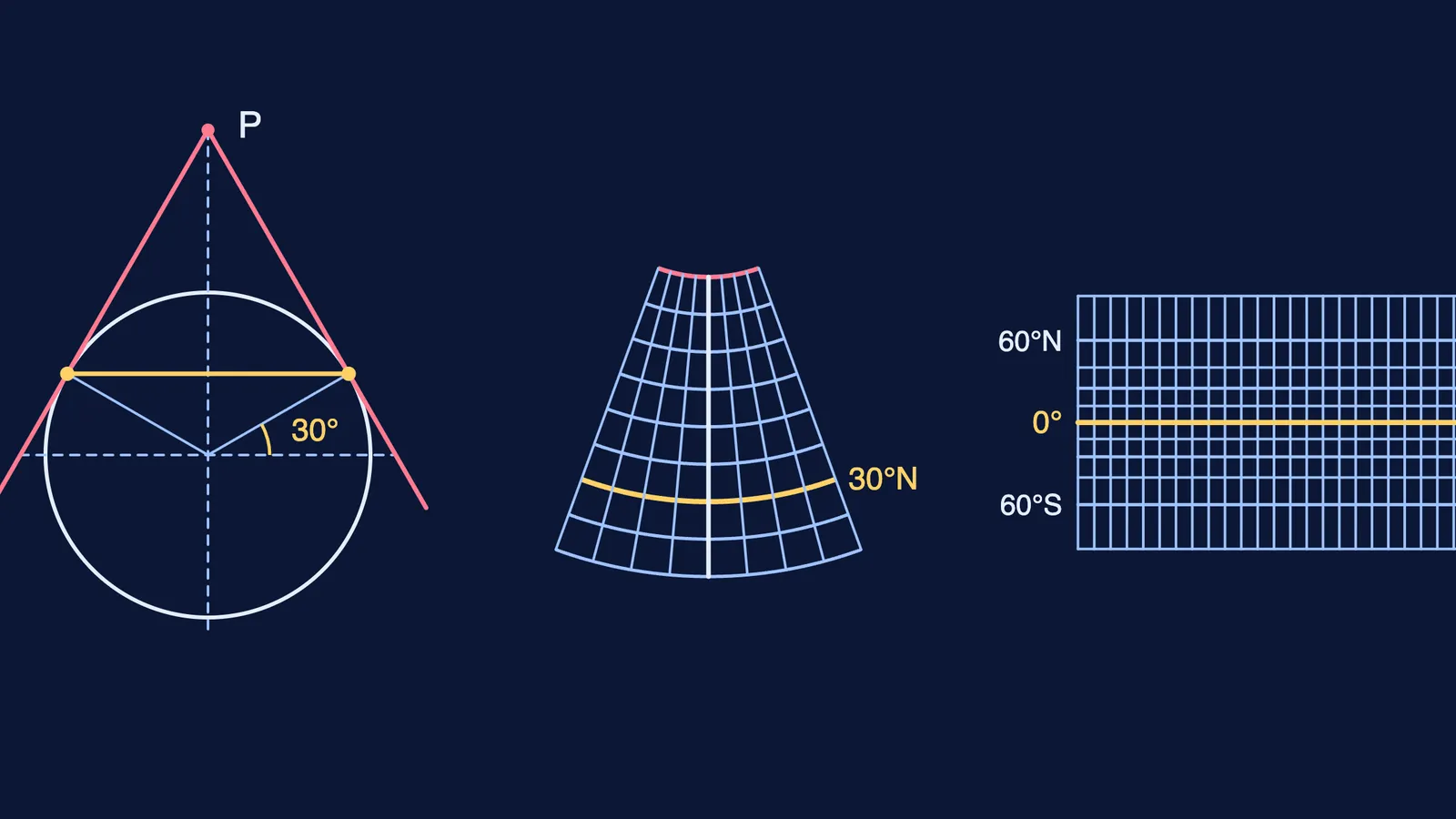
Draw a quarter circle of radius 2 cm and a tangent at 30° meeting the polar axis at P. This cone side measures R × cot 30° = 3.46 cm.
Parallel spacing is the arc for 10° on the circle: 2 × 3.14 × 2 × 10 ÷ 360 = 0.35 cm.
Meridian spacing on the standard parallel is the 10° arc on that parallel: 2 × 3.14 × 2 × cos 30° × 10 ÷ 360 = 0.30 cm.
Draw the central meridian. From its top (the apex) swing a 3.46 cm arc for 30°N, then arcs 0.35 cm apart.
Mark 0.30 cm steps along 30°N and join each to the apex.
Key properties: parallels are equally spaced concentric arcs; meridians are straight lines meeting at the pole; scale is true along meridians and the standard parallel; the pole is an arc; it is neither equal area nor orthomorphic. It suits east-west strips in mid-latitudes, such as NCERT's Trans-Siberian Railway and Narmada valley, but not world maps.
How do you draw Mercator's projection?
NCERT dates Mercator's projection to 1569. It is a mathematical, true-shape projection, and a straight line on it is a rhumb line: a path of constant bearing, useful in navigation (NCERT, Chapter 4).
Task: world map, R.F. 1:320,000,000, interval 15°.
R = 2 cm, as above.
Equator = 2πR = 2 × 3.14 × 2 = 12.56 cm. Divide it into 24 parts of 12.56 × 15 ÷ 360 = 0.52 cm and draw the meridians as straight vertical lines.
Multiply NCERT's table values by R to place the parallels: 15° at 0.53 cm, 30° at 1.10 cm, 45° at 1.76 cm, 60° at 2.63 cm and 75° at 4.05 cm.
The gaps grow towards the poles. That keeps shapes true but inflates high latitudes: NCERT notes the 30° parallel is 1.154 times its true length, and the poles cannot be shown. Use it for navigation, ocean currents and winds.
How to score full marks in the practical exam
Write the calculation first: R, then the spacings.
Label every parallel and meridian, and add the title, R.F. and interval.
Learn three properties, two limitations and two uses of each.
Keep the practical file (3 marks) neat and labelled.
Revise globes, latitudes and longitudes first. For the theory paper, see Interior of the Earth for Class 11; if mapmaking appeals, read about a career in cartography and GIS.
Practice questions for Map Projections class 11
(1 mark) Where is the source of light placed for a stereographic projection?
(2 marks) On a conical projection with its standard parallel at 30°N, along which lines is the scale true?
(3 marks) Why does the conical projection with one standard parallel suit the Trans-Siberian Railway but not a world map?
(5 marks) For 20°N-60°N and 10°W-70°E at 1:256,000,000 with a 10° interval, construct the conical projection with one standard parallel.
(5 marks) Draw Mercator's projection for the world at 1:500,000,000 with a 30° interval, and state two limitations.
If the cone still feels abstract, Fermi's AI tutor can work out what you already know and build a plan for the session.