
On this page
Remote sensing closes NCERT's Practical Work in Geography Part I, and it rewards learning one sequence and one colour table well. The CBSE 2026-27 Geography curriculum gives Introduction to Remote Sensing a weightage of 5 out of the 30 marks listed for the practical book, which are split into a 25-mark written exam, 3 marks for the practical file and 2 for the viva.
What is remote sensing in Class 11 geography?
Remote sensing is the collection and measurement of information about objects using a sensor that never touches them, as defined in the NCERT chapter Introduction to Remote Sensing. It needs three things: an object surface, a recording device and energy waves that carry the information. The term was first used in the early 1960s.
Only the visible, infrared and microwave regions of the electromagnetic spectrum are used, according to NCERT, so X-rays and gamma rays are not.
What are the stages in remote sensing?
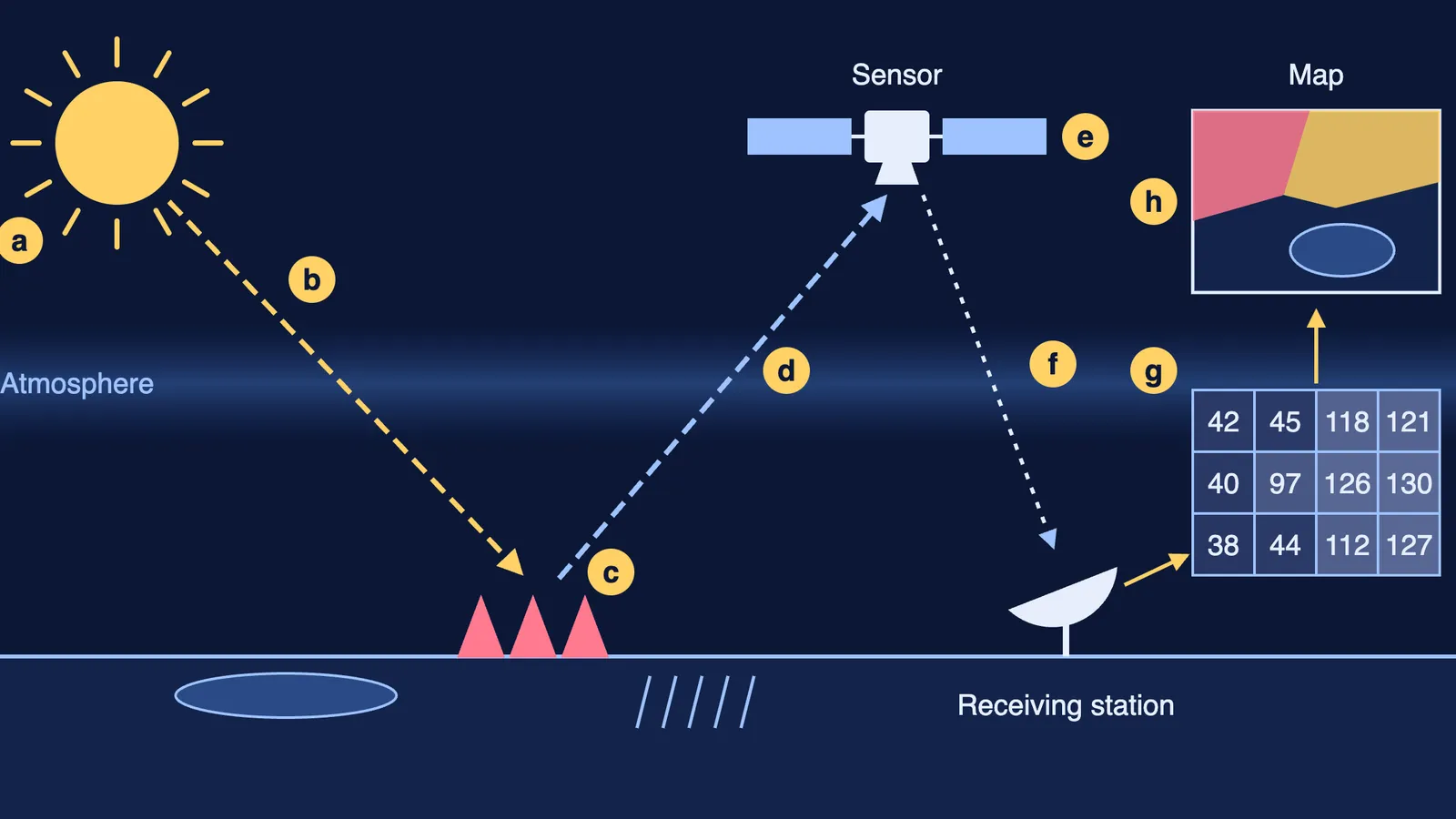
NCERT lists eight stages; 1 to 8 here match a to h in the diagram above:
Source of energy: mostly the Sun; radar supplies its own energy.
Transmission of energy to the Earth's surface as electromagnetic radiation, travelling at about 300,000 km per second.
Interaction with the surface: energy is absorbed, transmitted, reflected or emitted, differently by each object and in each band.
Propagation of reflected or emitted energy back through the atmosphere, where gases and water absorb some and dust scatters blue light.
Detection by the sensor on a satellite.
Conversion into photographic or digital data, sent to an Earth receiving station; one in India is at Shadnagar near Hyderabad.
Extraction of information, by digital image processing or visual interpretation, after errors are corrected.
Conversion of information into thematic maps and tables.
How are IRS and INSAT satellites different?
The NCERT chapter compares the two orbits:
Sun-synchronous (remote sensing, for example the Indian Remote Sensing series): near-polar orbit at 700 to 900 km, covering 81°N to 81°S, about 14 orbits a day, fine resolution from 182 m down to 1 m, used for Earth resources.
Geostationary (for example INSAT): about 36,000 km up, a 24-hour period, covers a third of the globe, coarse resolution of about 1 km, used for telecommunication and weather.
How do whiskbroom and pushbroom scanners work?
Satellites use non-photographic sensors called multispectral scanners, says NCERT.
Whiskbroom: a rotating mirror and a single detector sweep across the field of view, building the scene line by line.
Pushbroom: a row of detectors, one per ground cell across the swath. Detectors = swath ÷ spatial resolution. NCERT's example is SPOT's sensor: 60 km ÷ 20 m = 3,000 detectors.
Try made-up numbers: a 30 km swath at 5 m resolution needs 30,000 ÷ 5 = 6,000 detectors. Convert kilometres to metres first.
The chapter also names three sensor resolutions: spatial (the smallest object it can separate), spectral (the bands it records) and radiometric (how finely it separates brightness).
How do you read a false colour composite?
In a standard false colour composite, green radiation (0.5 to 0.6 µm) is shown as blue, red (0.6 to 0.7 µm) as green, and near infrared (0.7 to 0.8 µm) as red, according to the NCERT glossary. Healthy plants reflect strongly in near infrared, so they appear red.
The colours to learn from NCERT's Table 6.2:
Evergreen forest: red to magenta; cropped land: bright red.
Clear water: dark blue to black; turbid water: light blue.
High-density built-up area: dark blue to bluish green.
Fallow land and sandy areas: light blue to white.
Then apply the seven elements of visual interpretation: tone or colour, texture, size, shape, shadow, pattern and association.
Worked example: an image shows bright red rectangles, a dark patch beside them and a light-blue grid of identical blocks. Read it as cropped fields (bright red, regular pattern), a clear-water tank (dark blue to black) and a planned low-density settlement (light blue, repeated layout).
Practice questions for the written exam
Our own questions:
Name the three regions of the electromagnetic spectrum that NCERT says are used in remote sensing. (1 mark)
Why does a fresh-water lake appear black in an infrared band? (2 marks)
Calculate the detectors in a pushbroom scanner with a 45 km swath and 9 m resolution. (2 marks)
Explain stages c and d with one example each. (3 marks)
A weather office and a crop-mapping team each need satellite data. Which orbit suits each, and why? Give altitude, orbital period, resolution and coverage for both. (5 marks)
Answers: visible, infrared and microwave; fresh water absorbs most red and infrared energy; 45,000 ÷ 9 = 5,000; for 5, geostationary for weather, sun-synchronous for crops (see the list above).
For the practical file and viva, practise drawing the stages diagram and writing the FCC table from memory. Then revise how to read contour lines on a topographic map and why Greenland looks so big on maps.
Stuck on where to begin? Fermi's AI tutor can work out what you already know and build a plan for the session.