
On this page
"India and Her Neighbours" is Chapter 2 of NCERT's new Class 7 Social Science book, Exploring Society: India and Beyond, Part 2 (NCERT book number 0782, file code gees2; first edition November 2025, reprint 2026-27) (NCERT chapter PDF; book prelims). CBSE publishes no separate 2026-27 curriculum for Classes 6 to 8 (its 2026-27 curriculum page lists Classes 9 to 12), so Class 7 follows the NCERT book and is assessed by the school.
What does "neighbour" mean in this chapter?
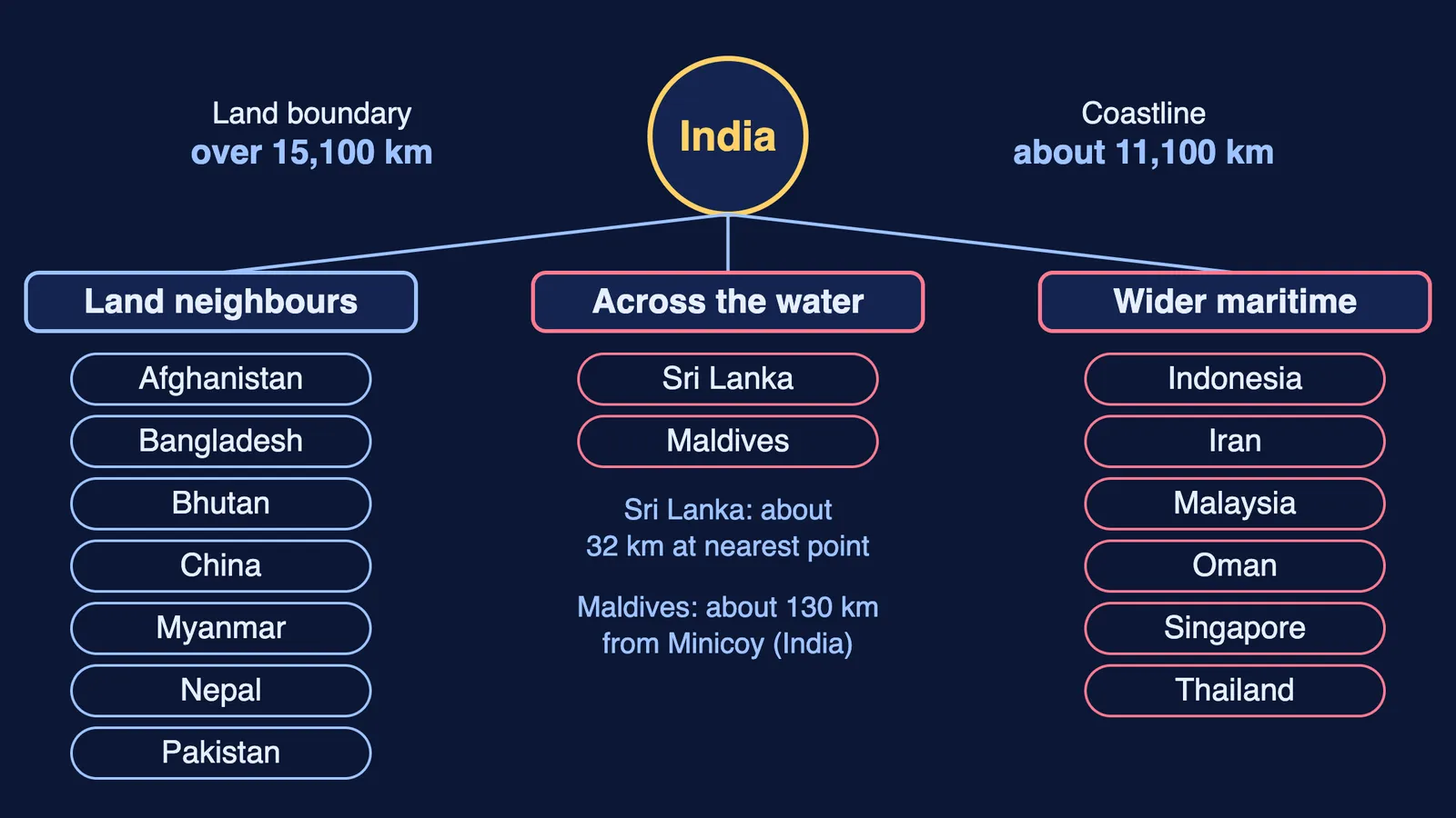
The chapter starts with the usual idea: a neighbour touches India on land. In that sense it names Pakistan, Afghanistan, China, Nepal, Bhutan, Bangladesh and Myanmar, and gives India's land boundary as over 15,100 km.
It then widens the idea. With sea on three sides and a coastline of about 11,100 km, India also has maritime neighbours.
A maritime neighbour, in the book's terms, is a country joined to India by the same sea or ocean; it need not share a land border. Sri Lanka and the Maldives are the nearest; Iran, Oman, Thailand, Malaysia, Singapore and Indonesia form the wider maritime neighbourhood.
What does the book say about India's land neighbours?
Key points, all from the NCERT text:
China: Buddhism travelled from India to China around the 1st century CE. Trade continues: India sends goods such as iron ore, chemicals and cotton yarn, and buys electronics and industrial equipment, and companies from each country operate in the other.
Pakistan: part of India before 1947. The book points to a shared heritage, including the Katas Raj temple complex, shared languages, food, music and festivals, and the Kartarpur Corridor for pilgrims, opened in 2019.
Bangladesh: a country since 1971, it shares the Bangla language with West Bengal, rivers of the Ganga and Brahmaputra systems, and the Sundarban mangrove forest, whose protection the two countries coordinate.
Nepal: an open border under the 1950 Treaty of Peace and Friendship, shared festivals, and India as Nepal's largest trading partner.
Bhutan: links through Buddhism and hydroelectric power; Bhutan also developed the idea of a Gross National Happiness index.
Myanmar: connected by land and across the Bay of Bengal; the book calls it India's gateway to Southeast Asia.
Afghanistan: linked in ancient times by the Uttarāpatha route; in recent decades India helped build its Parliament building and the Zaranj-Delaram highway.
The chapter also discusses challenges in some relationships alongside cooperation; read the book's own account of these.
Who are India's maritime neighbours?
Sri Lanka is about 32 km from India at the nearest point; Buddhism reached it in the 3rd century BCE through Aśhoka's children Mahendra and Sanghamitrā (NCERT). The Maldives, over 1,100 islets about 130 km from Minicoy, shares food, dance and Dhivehi words with south India.
Further east, the book traces Indian names in Thailand (Dvāravatī, Ayutthayā), Tamil as an official language of Singapore and the Borobudur Stūpa in Indonesia. To the west, it links Iran through the Avesta and Chabahar Port, and Oman through copper trade with the Harappans. One example of shared danger becoming cooperation is the 2004 tsunami, after which India joined Indian Ocean countries to build a warning network.
Worked example: how do you build a neighbour profile?
Use four headings. Here is Nepal, using only the book's facts:
Geography: set in the Himalayas, with a long, open border with India.
History and culture: pilgrims from both countries visit sacred sites across the border, such as the Paśhupatinātha temple in Kathmandu; Daśhain, Tihar and Holi are celebrated in both countries.
Cooperation today: the 1950 treaty provides for free movement of people and goods; India supplies goods such as petroleum, medicines and food, and Nepal exports farm produce, handicrafts and garments.
Shared responsibility: both countries work to keep the open border safe from misuse.
Now try the same four headings for Bhutan or the Maldives.
How does this chapter connect to the rest of the book?
The chapter points to other lessons: "Oceans and Continents" from Grade 6, the Sanchi and Bharhut stūpas in Part 1, and Chapter 5, "India, a Home to Many", for Zoroastrianism (book contents). It promises more on the International Solar Alliance in Grade 8.
For the same region later, see our guides to Contemporary South Asia in Class 12 and power sharing in Belgium and Sri Lanka for Class 10. For how routes link places, see transport and communication for Class 7.
Practice questions to test yourself
Marks are our suggestion.
Name one land neighbour and one maritime neighbour, and give one cultural link the chapter describes for each. (2 marks)
Which country does the book call India's gateway to Southeast Asia, and why does that matter for trade? (2 marks)
Using the four-heading profile, describe India's ties with Bangladesh. (4 marks)
Pick one link from the Maldives and one from Singapore that show influence from south India. (3 marks)
For Afghanistan, Iran and Oman, give one route, text or trade good that links each with India. (3 marks)
Not sure where to begin revising? Fermi's AI tutor works out what you already know and builds a plan for the session.