
On this page
Human Settlements is Chapter 2 of NCERT's Class 12 book India: People and Economy (NCERT, Reprint 2026-27). The CBSE 2026-27 Geography curriculum gives it 3 marks as Unit II and lists no map items for it. Do not confuse it with the Human Settlements topic in Fundamentals of Human Geography, which the curriculum lists for formative assessment only, not for summative assessment.
What are the types of rural settlements in India?
NCERT says the type depends on how large the built-up area is and how far apart the houses stand, shaped by physical, cultural and ethnic, and security factors (NCERT, Chapter 2):
Clustered (agglomerated or nucleated): a compact built-up area set apart from the fields. Found in fertile alluvial plains, the northeastern states, Bundelkhand and Nagaland (for defence) and Rajasthan (water scarcity).
Semi-clustered (fragmented): often a large village splits, with the dominant land-owning community at the centre and poorer groups on the edges. Found in the Gujarat plain and parts of Rajasthan.
Hamleted: one village broken into physically separate units that share a name, locally called panna, para, palli, nagla or dhani, often for social and ethnic reasons. Found in the middle and lower Ganga plain, Chhattisgarh and the lower Himalayan valleys.
Dispersed (isolated): isolated huts in remote forests or on small hills, caused by very broken terrain. Found in parts of Meghalaya, Uttarakhand, Himachal Pradesh and Kerala.
What makes a place urban under the census definition?
NCERT quotes the Census of India 1991 definition (NCERT, Chapter 2). A place is urban if it has a civic body (a municipality, a corporation, a cantonment board or a notified town area committee), 5,000 or more people, 400 or more persons per sq km, and 75 per cent or more of male workers outside agriculture.
Worked example, three made-up places, each with a notified town area committee:
Place A: 6,200 people, 520 per sq km, 80 per cent of male workers in non-farm work. Urban.
Place B: 9,000 people, 450 per sq km, 68 per cent. Fails the 75 per cent test.
Place C: 4,800 people, 610 per sq km, 85 per cent. Fails the 5,000 test.
The worker test counts male workers only, not the whole population.
How did towns evolve in India?
After Harappa and Mohenjodaro, NCERT sorts Indian towns into three groups (NCERT, Chapter 2):
Ancient towns, with a history of over 2,000 years, mostly religious and cultural centres: Varanasi, Prayagraj, Patna (Pataliputra), Madurai.
Medieval towns, about 100 of today's towns, mostly headquarters of principalities and kingdoms, built as fort towns on the ruins of ancient ones: Delhi, Hyderabad, Jaipur, Lucknow, Agra, Nagpur.
Modern towns: European trading ports (Surat, Daman, Goa, Pondicherry); British nodes (Mumbai, Chennai, Kolkata); hill towns; industrial towns after 1850 (Jamshedpur); after independence, administrative centres (Chandigarh, Bhubaneswar, Gandhinagar, Dispur), industrial centres (Durgapur, Bhilai) and satellite towns around Delhi (Ghaziabad, Rohtak, Gurugram).
The 2026-27 sample paper asks for the evolution of modern towns as a 3-mark answer, and the marking scheme lists five points and says "Any Three points".
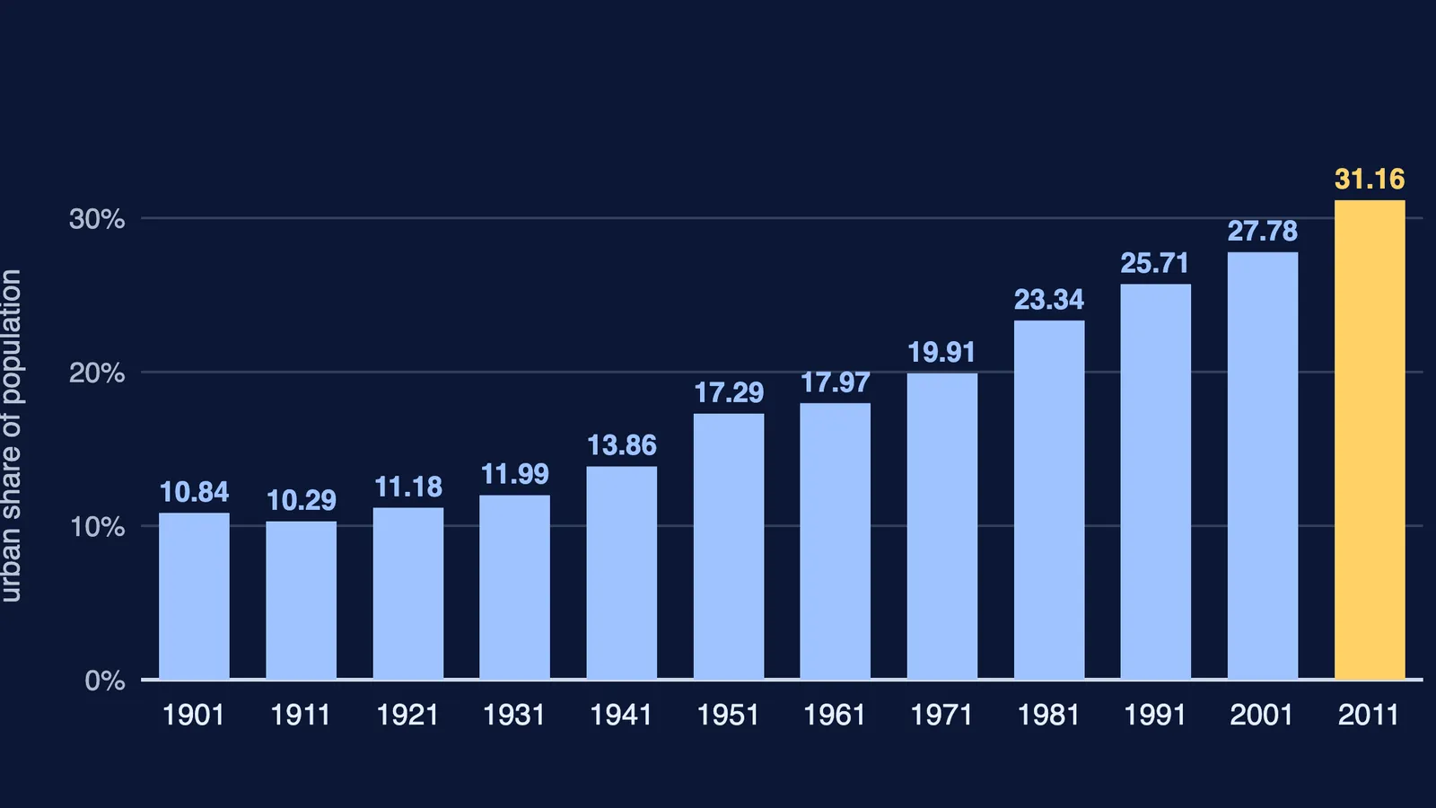
India's level of urbanisation, the urban share of total population, was 31.16 per cent in 2011 (NCERT, Table 2.1). The chart above starts at 10.84 per cent in 1901. Urban population grew eleven-fold in the twentieth century, though growth slowed in the two decades to 2011.
What is the functional classification of towns?
NCERT classifies towns by dominant function (NCERT, Chapter 2):
Administrative: Chandigarh, New Delhi, Bhopal, Shillong.
Industrial: Salem, Coimbatore, Jamshedpur, Bhilai.
Transport: ports such as Kandla, Cochin and Vishakhapatnam, or inland hubs such as Agra, Itarsi and Katni.
Commercial: Kolkata, Saharanpur, Satna.
Mining: Raniganj, Jharia, Digboi, Singrauli.
Garrison cantonment: Ambala, Jalandhar, Mhow, Babina, Udhampur.
Educational: Roorkee, Aligarh, Pilani, Varanasi.
Religious and cultural: Mathura, Amritsar, Puri, Tirupati.
Tourist: Nainital, Shimla, Ooty, Mount Abu.
NCERT's key point: as specialised cities grow into metropolises they become multifunctional, so one class no longer fits. Varanasi appears in NCERT's ancient, educational and religious lists. The chapter's Smart Cities Mission box describes cities that give residents core infrastructure, a decent quality of life and a clean, sustainable environment.
How should you practise Human Settlements for the board exam?
The sample paper has 1-mark MCQs, 3-mark answers of 80 to 100 words and 5-mark answers of 120 to 150 words. Try these original questions:
(1 mark) In a village, the land-owning community lives at the centre and poorer groups live on the edges. Which settlement type is this?
(1 mark) Name one mining town and one garrison town from NCERT's list.
(3 marks) Why do some large villages split into hamlets? Name two regions.
(3 marks) Using two examples each, show how medieval towns differ from ancient towns.
(3 marks) A place has a municipality, 7,500 people, 380 per sq km and 82 per cent male non-farm workers. Is it urban? Explain.
See our Class 12 guides to land resources and agriculture, primary activities and human development.
If you do not know where to start with a topic, Fermi's AI tutor works out what you already know, builds a plan for the session, and teaches through it.