
On this page
Primary activities are the ones that depend directly on the environment, because they use the earth's resources: land, water, vegetation, building materials and minerals (NCERT Class 12 Fundamentals of Human Geography, Chapter 4, Reprint 2026-27). Below: what the 2026-27 syllabus keeps, the comparison the sample paper asks for, and the five world map items.
How many marks is Primary Activities in 2026-27?
The CBSE Geography curriculum for 2026-27 gives Unit III a combined weightage of 19 marks. That unit holds five chapters, Primary Activities through International Trade, and there is no separate figure for this chapter. Map work on the world political map is a further 5 marks.
The syllabus keeps the whole chapter, from hunting and gathering through every farming type to co-operative and collective farming and mining.
What are the types of primary activities?
Gathering is the oldest economic activity. NCERT places it in high latitudes (northern Canada, northern Eurasia, southern Chile) and low latitudes (the Amazon Basin, tropical Africa, the northern fringe of Australia, interior Southeast Asia). It needs little capital and yields little surplus.
Nomadic herding is subsistence: the herd supplies the family's food, clothing, shelter, tools and transport. Its core region runs from the Atlantic shores of North Africa across Arabia into Mongolia and Central China. A second region covers the Eurasian tundra, with small areas in south-west Africa and Madagascar. Seasonal movement between plains and mountain pastures is called transhumance; in the Himalayas the Gujjars, Bakarwals, Gaddis and Bhotiyas practise it. Nomad numbers are falling because of political boundaries and new settlement plans.
Commercial livestock rearing happens on large, fenced ranches. Only one kind of animal is reared, and the number kept matches the pasture's carrying capacity. The chapter names New Zealand, Australia, Argentina, Uruguay and the USA.
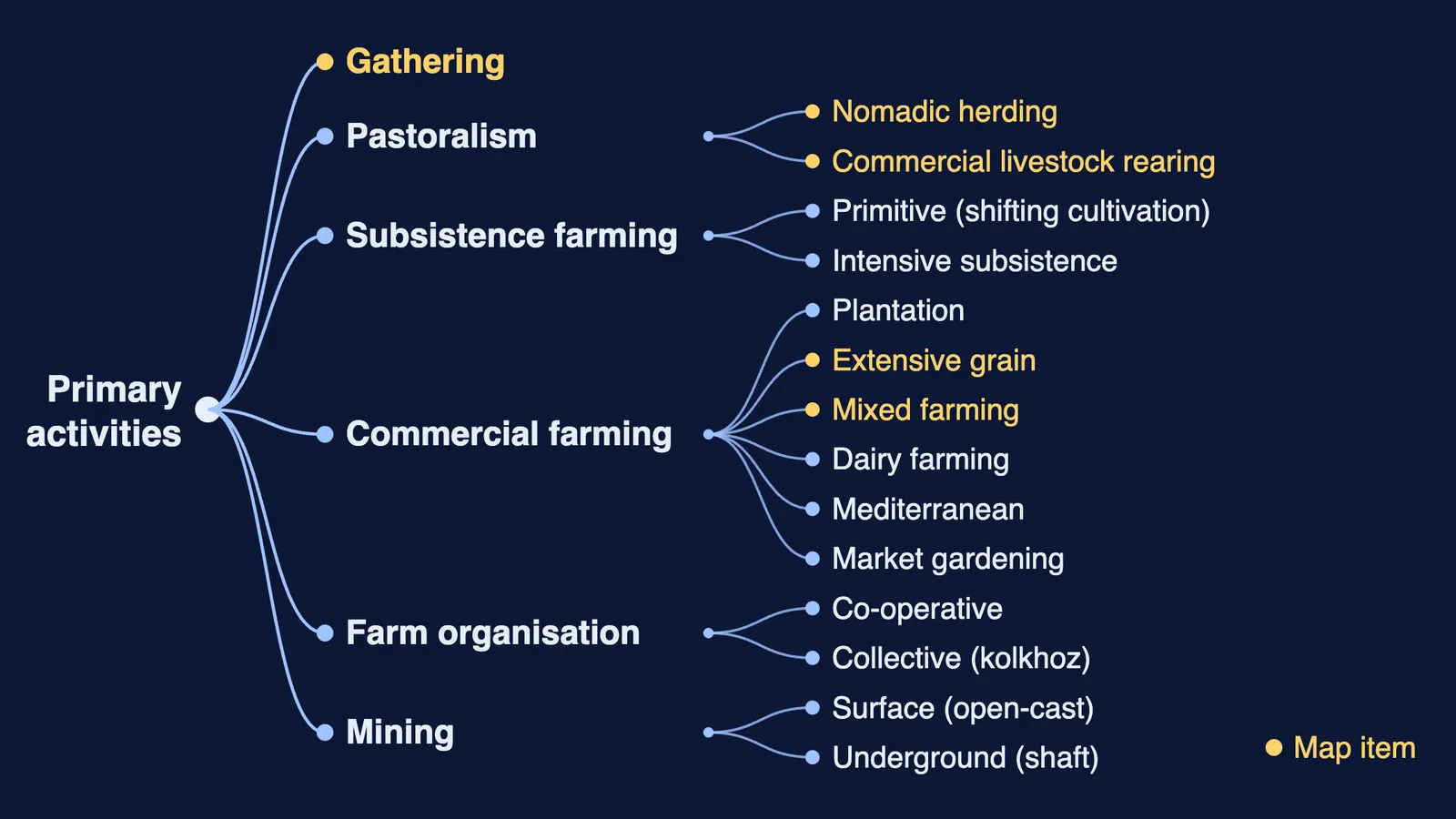
Agriculture splits into subsistence and commercial types. Shifting cultivation (slash and burn) clears forest by fire, and the farmer moves on after 3 to 5 years once the soil loses fertility. Its local names include jhuming (north-eastern India), milpa (Mexico and Central America) and ladang (Malaysia and Indonesia). The diagram at the top maps every commercial type.
Mining depends on physical factors (size, grade and mode of occurrence of the deposit) and economic ones (demand, technology, capital, labour and transport costs). Open-cast mining is cheapest for minerals near the surface; shaft mining reaches deep ores but is risky.
How do you distinguish intensive subsistence from extensive grain farming?
This contrast came up as a 5-mark question in CBSE's 2026-27 sample paper, and the marking scheme awards 2½+2½=5 for any five of the seven differences it lists. Answer in matched pairs:
Region: densely populated monsoon Asia versus semi-arid interiors of the mid-latitudes.
Main crop: rice dominates the wet paddy type (wheat, soyabean, barley, sorghum elsewhere) versus wheat, with corn, barley, oats and rye.
Farm size: very small holdings versus very large farms.
Labour and machines: family labour and little machinery versus mechanisation from ploughing to harvest.
Productivity: high output per unit area but low output per worker versus low output per acre but high output per worker.
Which map items come from this chapter?
The curriculum lists five areas to identify on the outline world political map (CBSE curriculum 2026-27):
Areas of subsistence gathering
Major areas of nomadic herding of the world
Major areas of commercial livestock rearing
Major areas of extensive commercial grain farming
Major areas of mixed farming of the World
The sample paper asked students to identify an area of nomadic herding. For grain farming, learn NCERT's six names: the steppes of Eurasia, the Prairies of Canada and the USA, Argentina's Pampas, South Africa's Velds, the Downs of Australia and New Zealand's Canterbury Plains. Mixed farming belongs to developed regions: eastern North America, north-western Europe, temperate parts of the southern continents and some of Eurasia. Unit II has no world map items; its chapter is covered in our notes on world population distribution, density and growth.
What practice questions should you try?
These are our own, in the paper's formats:
(1 mark) Why are the Netherlands linked with market gardening?
(3 marks) Why does dairy farming need so much capital? Give three reasons.
(3 marks) Explain why the cycle of shifting cultivation keeps getting shorter.
(5 marks) Compare co-operative and collective farming on ownership, labour and an example country.
(5 marks) Explain how the physical and economic factors of a deposit decide whether mining it is profitable.
Check your answers against the chapter. Export links continue in our notes on international trade for Class 12 geography.
If you do not know where to start with a subject, Fermi's AI tutor can work out what you already know and build a plan for the session.