
On this page
Geographical Diversity of India is Chapter 1 of Exploring Society: India and Beyond, Part I, the new NCERT Social Science book for Class 7 (code gees1, First Edition April 2025, reprint 2026-27). It opens Theme A and "flies" you over the country, region by region.
A note on assessment: CBSE's 2026-27 curriculum page lists curricula for Classes IX to XII only. Classes 6 to 8 follow the NCERT book, so this chapter is assessed by the school.
What are the key geographical features of India in Class 7?
The chapter groups India into five broad regions for discussion: the great mountain zone, the Ganga and Indus plains, the desert, the southern peninsula and the islands. It then visits ten stops, in this order:
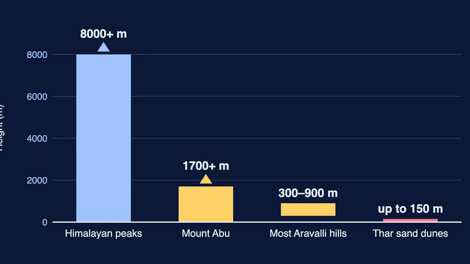
The Himalayas: about 2500 km long, with many peaks over 8000 metres, in three ranges: Himadri (Greater), Himachal (Lower) and the Shivalik Hills (Outer). Snowmelt feeds the Ganga, Indus and Brahmaputra, so it is sometimes called the "Water Tower of Asia".
The cold desert: Ladakh, with winters below -30°C and very little rain.
The Gangetic (Northern) Plains: fertile soil from river minerals, flat land for transport, and a large share of India's people.
The Thar Desert: dunes shaped by wind, sometimes up to 150 metres high, across Rajasthan, Gujarat, Punjab and Haryana.
The Aravalli Hills: about 2.5 billion years old; Mount Abu rises above 1700 m, though most hills are 300 to 900 m. They help stop the Thar from spreading east.
The Peninsular Plateau: water on three sides, the Western and Eastern Ghats on its edges, the Deccan Plateau between.
The coasts: a coastline of over 7500 km; estuaries on the west coast, wide deltas on the east coast.
The islands: Lakshadweep (36 coral islands) and the Andaman and Nicobar Islands (more than 500 volcanic islands, including Barren Island, India's only active volcano).
The Sundarbans: the Ganga-Brahmaputra delta, about half in India and the rest in Bangladesh.
The hills of the Northeast: the Garo, Khasi and Jaintia hills of the Meghalaya Plateau, with some of the heaviest rainfall in the world.
How does geography affect people's lives?
Strong answers follow a three-step chain: feature, then condition, then adaptation. Examples from the chapter:
Thar Desert, then scarce water, then taanka and kunds that store rainwater, and utensils scoured with sand.
Western Himalaya, then cold and mild earthquakes, then kath-kuni houses of local stone and wood that stay warm and resist damage.
Northern Plains, then flat, fertile land, then dense farming and long road and rail networks.
Plateau rivers falling over rocky ground, then waterfalls, then hydroelectricity and irrigation.
An answer that stops at the feature ("the Thar is hot") is one-third done. Ask "so what?" twice.
Worked example: how fast are the Himalayas growing?
The chapter says India was once part of Gondwana and collided with Eurasia about 50 million years ago, crumpling the land into the Himalayas. It gives two rates: India still pushes into Asia by about 5 cm a year, and the Himalayas rise by about 5 mm a year.
Take our own span: 40 years.
Northward push: 5 cm × 40 = 200 cm = 2 m.
Rise in height: 5 mm × 40 = 200 mm = 20 cm.
So the land moves ten times farther sideways than the mountains grow upward (200 cm against 20 cm). Check units first: cm and mm differ by a factor of 10, where most slips happen.
How does Chapter 1 connect to the rest of the book?
The contents page shows Chapter 1 is followed by Understanding the Weather (Chapter 2) and Climates of India (Chapter 3), so these landforms become the background for rainfall and seasons. The chapter says the Tapestry of the Past chapters will show rivers used for travel and trade. Keep the physical map at the end of the book open while you revise.
For how plates build mountains, see the Class 9 guide Shaping of the Earth's Surface. The older Class 7 book's chapter on life in the deserts of the Sahara and Ladakh adds detail on the cold desert, and major landforms of the Earth refreshes mountains, plateaus and plains.
Practice questions (our own)
Mark values are our suggestion only.
Name the three ranges of the Himalayas and give one feature of each. (3 marks)
Ladakh and the Thar are both deserts. Give two differences between them. (2 marks)
Explain why the southern part of India is called a peninsular plateau, and name the two mountain ranges on its edges. (3 marks)
Use the feature, condition, adaptation chain to explain one way of life in the Northeast hills. (3 marks)
If the Himalayas rise 5 mm a year, how much would they rise in 120 years? Show units. (2 marks)
Not sure which region to revise first? Fermi's AI tutor works out what you already know and builds a plan for the session.