
On this page
For 2026-27, Class 9 uses NCERT's new two-part Social Science textbook, *Understanding Society: India and Beyond*, in place of the old separate history, geography, civics and economics books. Its Chapter 2, Shaping of the Earth's Surface, asks what builds land up and what wears it down. Forces inside the Earth (plates, earthquakes, volcanoes, folding, faulting) raise mountains and open oceans; forces on the surface (weathering and erosion by water, ice, wind, waves and groundwater) carve them down. It ends with landform disasters.
What is inside the Earth?
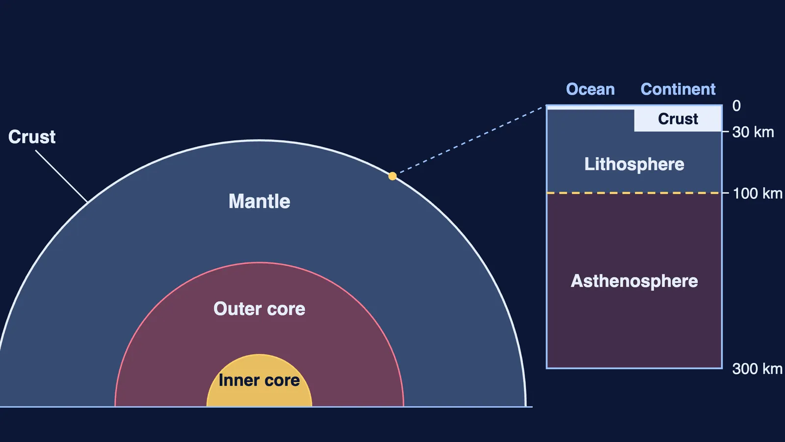
The Earth has three main layers: crust, mantle and core. The US Geological Survey gives the sizes the chapter's diagram uses: the crust is about 5 km thick under oceans and about 30 km under continents, the mantle is about 2,900 km thick, the liquid outer core about 2,200 km and the solid inner core about 1,250 km. The chapter's text gives crust ranges: 5-7 km under oceans and 30-40 km under continents.
The lithosphere is the crust plus the rigid top of the mantle, and it is what breaks into plates. The asthenosphere below is hot, partly molten rock that flows slowly, so plates can move over it. Plates are pieces of lithosphere, not just crust.
What is plate tectonics, and why do plates move?
Plate tectonics is the idea that the Earth's outer shell is split into large and small plates that move slowly, usually a few centimetres a year, according to the NCERT chapter. Heat from the core drives convection currents in the mantle: hot material rises, cooler material sinks, and the flow pushes and pulls the plates. The major plates the chapter names are the Pacific, Eurasian, African, North American, South American, Indo-Australian and Antarctic plates.
What happens at a plate's edge depends on how the two plates meet:
Convergent (moving together): two continents crumple into fold mountains; an ocean plate meeting a continent sinks under it, giving volcanoes and earthquakes.
Divergent (moving apart): magma rises and makes new crust, as at the Mid-Atlantic Ridge, which spreads at about 2.5 cm a year according to USGS.
Transform (sliding past): crust is neither made nor destroyed, but the grinding causes earthquakes, as on the San Andreas Fault.
India is the classic convergent case. USGS explains that the Himalayas began forming 40 to 50 million years ago when India collided with Eurasia, and that they are still rising by more than 1 cm a year. Most earthquakes and volcanoes sit along plate boundaries, especially around the Pacific's Ring of Fire. For an Indian case, read why the Andaman Islands have earthquakes and what the 2004 tsunami did.
Convection is a physics idea; if it feels abstract, the Fermi Concept Library has every concept in physics, chemistry, biology, mathematics and computing, each with its own lesson, so you can learn why heated material rises.
How do weathering, erosion and the agents of gradation shape landforms?
Weathering breaks rock in place; erosion also carries it away. The chapter names physical, chemical and biological weathering and five agents of gradation: running water, glaciers, wind, waves and groundwater. Use this check on any landform:
Inside or outside force? Mountains from colliding plates and volcanoes are internal; most other features are external.
Which agent? Water, ice, wind, waves or groundwater.
Erosion or deposition? Valleys, cliffs, caves and yardangs are cut; deltas, beaches, moraines and dunes are laid down.
Where in the system? For rivers: upper course (V-shaped valleys, waterfalls), middle course (meanders, oxbow lakes), lower course (deltas, levees).
Worked example: the Sundarbans. Outside force; agent is running water (the Ganga-Brahmaputra system); deposition; lower course. So it is a delta, and that explains its fertile soil and its flood risk.
For the four disasters (landslides, avalanches, glacial lake outburst floods and dust storms), learn a cause, a prone region and a mitigation. For how Earth's spheres connect, see Earth as a System for Class 9; for a look ahead, there is landforms and their evolution in Class 11.
What mistakes do students make in this chapter?
Treating weathering and erosion as the same. Only erosion moves material.
Writing that plates float on liquid. The asthenosphere is semi-molten and flows slowly; the mantle is mostly solid.
Saying every convergent boundary makes fold mountains. Continent-continent does; ocean-continent sends one plate under, with volcanoes.
Mixing up stalactites (hang from the ceiling) and stalagmites (rise from the floor).
How much does this chapter count in CBSE 2026-27?
The CBSE Class IX Social Science curriculum for 2026-27 gives this chapter 8 instructional hours and expects you to locate major plates on a world map, explain weathering and erosion, and suggest disaster mitigation. It gives no marks yet (a note says the course structure will be provided shortly), so check your school's paper design.
Practice:
Draw the Earth's layers and mark where the lithosphere ends.
Explain why the India-Eurasia collision built fold mountains instead of one plate sinking under the other.
A photo shows a U-shaped valley. Name the agent and one landform you would expect nearby.