
On this page
From 2026-27, Class 9 students use a new NCERT Social Science book, *Understanding Society: India and Beyond*. Part 2 opens with Chapter 1, Oceans and Life, covering the sea floor, moving water, marine resources, hazard warnings and who controls the sea.
What does the ocean floor look like?
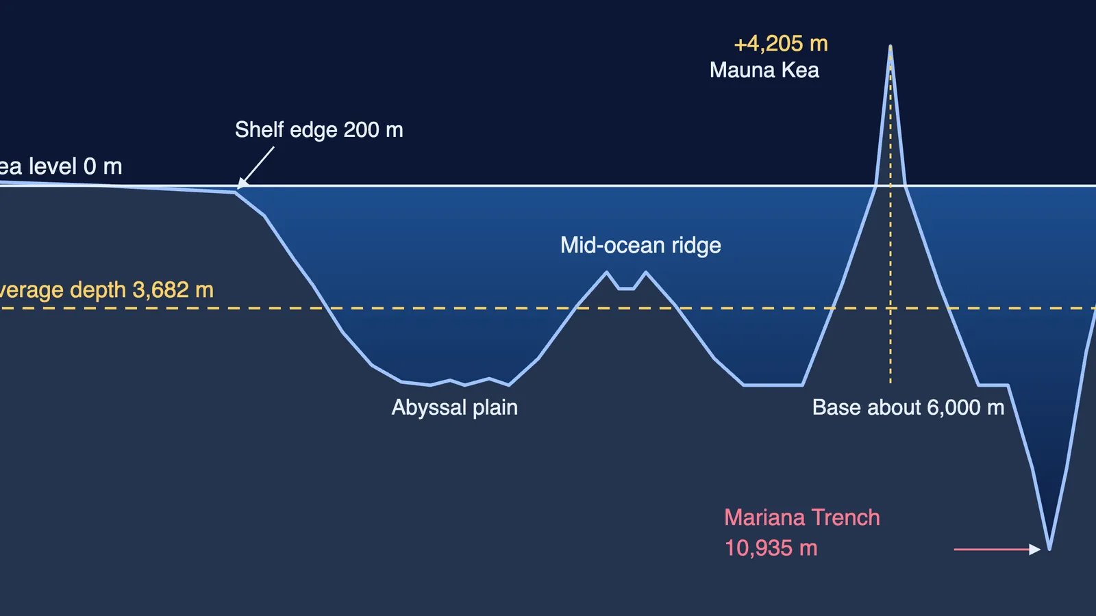
The ocean floor has relief just like land, with mountains, plains, valleys and trenches, according to the NCERT chapter. Moving out from a coast, you cross the continental shelf, slope and rise to the abyssal plain and mid-ocean ridge; seamounts, guyots and trenches dot the floor. The chapter places coastal fish on the shelf at depths of 0 to 200 m.
Real numbers make the profile stick:
NOAA gives the average ocean depth as 3,682 metres, and the Challenger Deep in the Mariana Trench as about 10,935 metres.
NOAA says the mid-ocean ridge is the longest mountain range on Earth, at 40,389 miles (about 65,000 km), about 90 per cent of it under the sea.
USGS says Mauna Kea rises 13,796 feet above sea level and about 19,700 feet below it, nearly 33,500 feet in all, more than Everest's 29,028 feet.
How do waves, tides and currents move ocean water?
Each movement has its own cause, and figures here are from the NCERT chapter.
Waves are made mainly by wind. The chapter calls them "coastal architects" because they cut caves, arches and stacks and build beaches. Tsunamis are giant waves caused mostly by undersea earthquakes, with run-up heights of up to 30 m, or more in extreme cases.
Tides are the rise and fall of the sea, twice a day in most places, caused by the pull of the Moon and Sun. When Sun, Earth and Moon line up (new and full moon), spring tides give the biggest range; at quarter moons, neap tides give the smallest. The Gulf of Khambhat has a tidal range of about 12 m.
Currents are steady streams set moving by wind and by temperature and salinity differences, and steered by Earth's rotation (the Coriolis force) and coastline shape. Warm currents come from warmer regions, cold ones from colder regions, and where they meet, nutrient-rich water makes good fishing grounds.
Tides come down to gravitation. If that feels shaky, the Fermi Concept Library covers every concept in physics, so you can revise gravity before returning to spring and neap tides. For the senior version, see movements of ocean water for Class 11.
Why do marine resources and maritime zones matter?
Marine resources are living (fish, seaweed) or non-living (oil, gas, minerals, energy from tides and waves). India's coastline is 11,098.81 km long, and about 90 per cent of world trade by volume goes by sea (NCERT).
Zones are measured in nautical miles (NM) from the baseline; one nautical mile is exactly 1,852 m. Remember the ladder:
Territorial sea, up to 12 NM: almost like land; foreign ships may pass peacefully.
Contiguous zone, up to 24 NM: limited control over customs, tax and illegal immigration.
Exclusive Economic Zone, up to 200 NM: special rights over resources, but not full ownership of the water.
High seas, beyond all EEZs: about 64 per cent of the ocean, open to every country.
Worked example: a fishing boat 150 NM from India's baseline is past 24 NM but inside 200 NM, so it is in India's EEZ, where India has rights over the fish.
How do early warning systems protect the coast?
The 2004 Indian Ocean tsunami killed about 2,30,000 people, and Tamil Nadu, Puducherry, Andhra Pradesh, Kerala and the Andaman and Nicobar Islands were badly hit (NCERT). India's warning chain now runs: seismic stations detect, sea-floor recorders confirm, tide gauges and radars track, and alerts go out by satellite and SMS. To see why the Andamans sit on a fault line, read what 2004 did to the Andaman Islands.
What mistakes do students make in Oceans and Life?
Thinking spring tides happen in spring. They come at every new and full moon.
Writing that the EEZ belongs to India like land. It gives resource rights, not ownership.
Adding 24 NM after the territorial sea. Both zones are counted from the baseline (NCERT).
Calling tsunamis wind waves. They mostly come from undersea earthquakes.
How much does Oceans and Life count in CBSE 2026-27?
The CBSE Class IX Social Science curriculum for 2026-27 gives this chapter 7 instructional hours and says the course structure with marks will be provided later, so check with your school.
Try these:
Why might a big ship wait for high tide before entering a shallow port?
A boat is 20 NM from the baseline. Name the zone and one thing the country controls there.
Why does Norway's coast stay fairly ice-free so far north?
Not sure where to start? Fermi's AI tutor works out what you already know and builds a plan for the session.