
On this page
Landforms and their Evolution is Chapter 6 of the NCERT Class 11 textbook Fundamentals of Physical Geography. Once weathering has loosened rock, what do running water, groundwater, glaciers, waves and wind carve away, and what do they build? If you have just studied the interior of the Earth, this is where the surface gets its shape.
Is landforms and their evolution in the CBSE Class 11 syllabus for 2026-27?
Yes, but the exam list is narrower than the textbook. The CBSE Geography curriculum for 2026-27 places Chapter 6 in Unit III, Landforms, and lists only two topics for it: erosional and depositional landforms of running water, and of wind. Unit III (Geomorphic Processes plus this chapter) carries 6 of the 35 marks for the Fundamentals book.
The NCERT chapter, reprinted for 2026-27, still has full sections on groundwater, glaciers, and waves and currents. Learn running water and wind thoroughly for the CBSE paper; read the other three for understanding.
NCERT calls a landform a small-to-medium parcel of the Earth's surface, and a landscape a group of related landforms. "Evolution" means each landform changes through stages, which the chapter compares to youth, maturity and old age.
What landforms does running water make?
The NCERT chapter describes three stages:
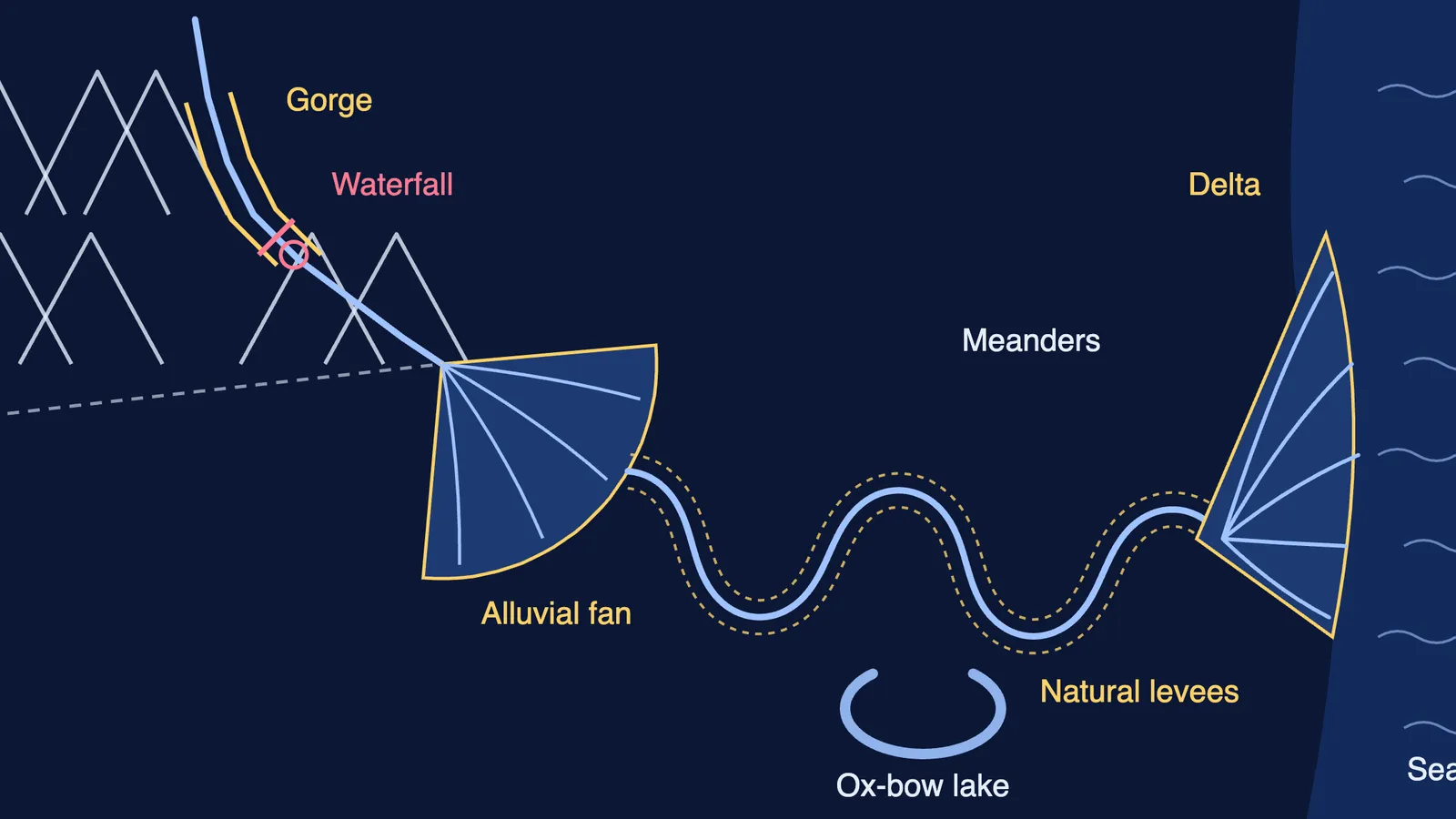
Youth: few streams, shallow V-shaped valleys; waterfalls and rapids where hard rock is exposed.
Mature: many streams, deep V-shaped valleys, wider floodplains; waterfalls and rapids disappear.
Old: streams meander over vast floodplains with natural levees and ox-bow lakes. Long erosion can leave an almost flat peneplain with resistant remnants called monadnocks.
Erosional landforms come from cutting down and sideways. A gorge has steep, almost straight sides and is about as wide at the top as at the bottom; a canyon has step-like sides and is wider at the top. Potholes are round hollows ground into rocky stream beds by rotating pebbles; plunge pools are the large ones at the foot of waterfalls. Incised meanders are deep loops cut into hard rock, and river terraces mark old valley-floor levels.
Depositional landforms appear where the slope eases and the river drops its load: alluvial fans at the foot of mountains, deltas at the sea, floodplains, natural levees (ridges of coarse sediment along the banks) and point bars (deposits on the inside of a bend). Indian examples to memorise: a Kaveri gorge near Hogenakkal, the Krishna delta, and ox-bow lakes along the Burhi Gandak near Muzaffarpur.
What do groundwater, glaciers and waves build?
Groundwater works mainly by dissolving limestone and dolomite, producing karst topography. NCERT gives sinkholes a depth from under half a metre to 30 metres or more (NCERT chapter). Joined sinkholes form uvalas; grooved surfaces are lapies; underground you find caves, stalactites, stalagmites and pillars.
Glaciers usually move a few centimetres to a few metres a day, the same chapter says. They cut cirques (often holding tarn lakes), horns, arêtes and U-shaped troughs, and drowned troughs become fjords. They leave moraines, eskers, outwash plains and drumlins. The Bhagirathi starts at Gaumukh, the snout of the Gangotri glacier; for why such glaciers are retreating, read why Himalayan glaciers are shrinking.
Waves shape two kinds of coast. High rocky coasts are dominated by erosion: cliffs, wave-cut terraces, sea caves and stacks. Low sedimentary coasts are dominated by deposition: beaches, dunes, bars, spits and lagoons. NCERT calls India's west coast high and rocky and its east coast low and sedimentary, which pairs well with India's location and physiography.
Which landforms does wind create in deserts?
Wind erodes by deflation (lifting fine particles), abrasion and impact, but NCERT stresses that sheet floods after rare, heavy rain do much of a desert's erosion too.
Erosional: pediments (gentle rocky floors at a mountain's foot) that grow as slopes retreat until only an inselberg stands on a pediplain; playas and salt-covered alkali flats; deflation hollows; mushroom, table and pedestal rocks.
Depositional: wind sorts grains well. Barchans are crescents with wings pointing downwind; parabolic dunes are reversed barchans on partly vegetated sand; a seif has one wing; longitudinal dunes form when sand is scarce and wind steady; transverse dunes lie across the wind.
How should you revise landforms and their evolution?
Run every agent through the same five steps:
Agent and where it works (plains, limestone, mountains, coasts, deserts).
Main process (cutting, solution, plucking, wave pounding, deflation).
Erosional landforms.
Depositional landforms.
One Indian example from the chapter.
Then drill the pairs examiners like to contrast: gorge and canyon, natural levee and point bar, V-shaped and U-shaped valley, glacial till and outwash, rocky and sedimentary coast, barchan and parabolic dune. Finally, sketch a river from source to sea from memory and label every landform in its place.
If you are unsure where to begin, Fermi's AI tutor works out what you already know and builds a plan for the session, so you start with a clear next step.
Start with running water and wind, then read the rest once to see the same erosion-then-deposition story repeat.