On this page
Your Class 6 chapter on landforms asks two things: tell three shapes of land apart, and explain why people live where they do. NCERT's new textbook covers it in Chapter 3, Landforms and Life. Here are the definitions, the types of mountains, and a quick test for any picture.
What are the major landforms of the Earth?
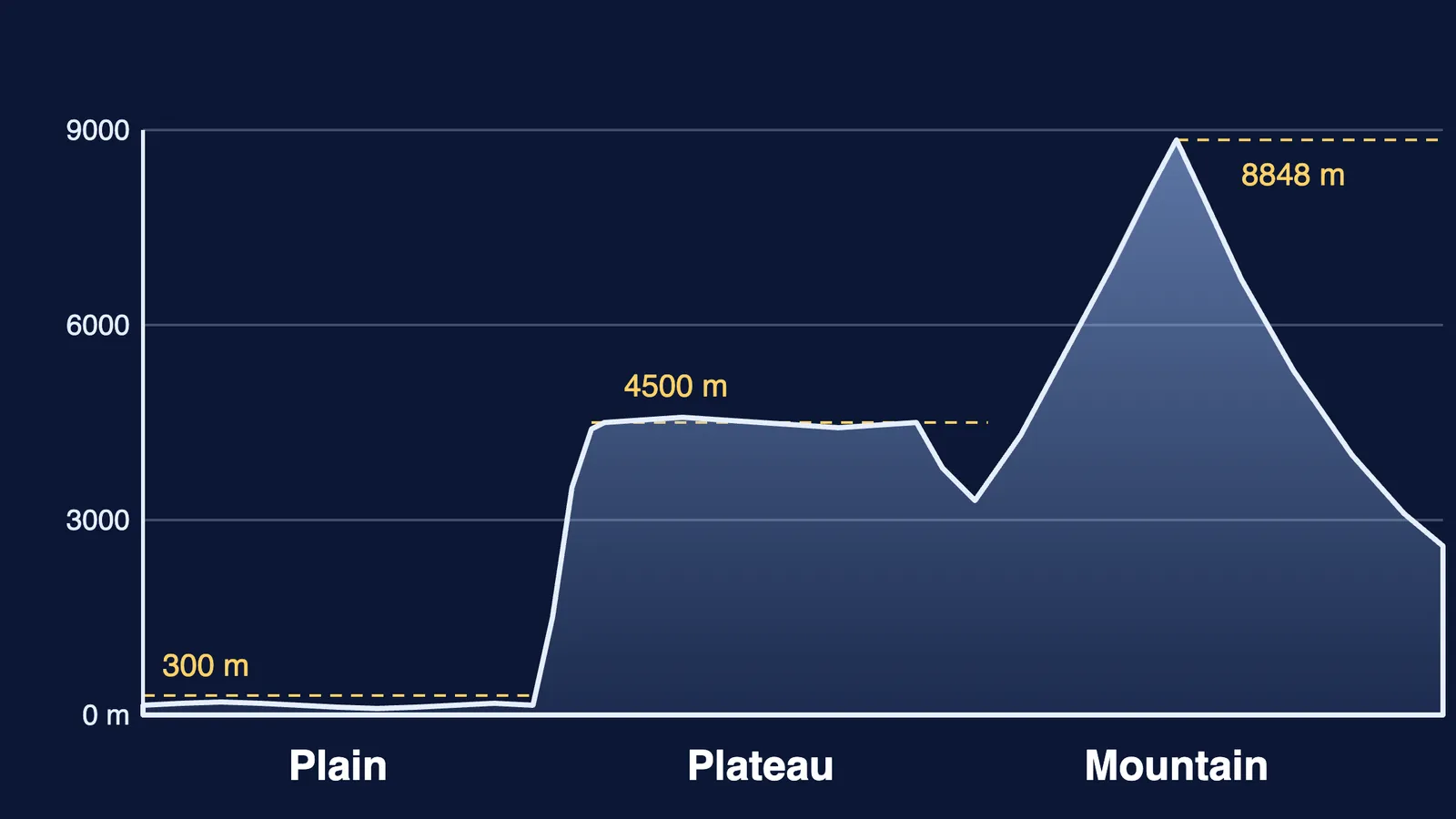
A landform is a physical feature on the surface of the Earth, and NCERT divides landforms into three categories: mountains, plateaus and plains (NCERT Class 6, Chapter 3).
Mountain: much higher than the land around it, with a broad base, steep slopes and a narrow summit. Lower highlands with gentler slopes and rounded tops are hills.
Plateau: rises from the surrounding land and has a more or less flat top; some sides are often steep.
Plain: a wide, flat or gently rolling surface with no large hills or deep valleys, generally not more than 300 metres above sea level.
Mount Everest, at 8,848 m, is the highest mountain in the world, the same chapter notes.
What are the types of mountains?
The new NCERT chapter does not sort mountains by how they formed, but many reference books do. The National Institute of Open Schooling classifies them by mode of formation (NIOS Geography, Lesson 7):
Fold mountains form when layers of sedimentary rock are squeezed by sideways forces for millions of years and bend into folds. Examples: the Himalayas, Alps, Rockies and Andes.
Block mountains form when pulling forces crack rock along faults and the block between two faults is raised, or the land on either side sinks. Examples: the Vosges in France and the Black Forest in Germany.
Volcanic mountains grow as molten rock from eruptions piles up around a vent. Examples: Mauna Loa in Hawaii, Fuji in Japan and Vesuvius in Italy.
NIOS adds a fourth type, residual mountains: hard rock left standing after erosion removes softer rock, as in the Nilgiris and the Aravalis. The US National Park Service links these shapes to moving plates: folded mountains can form where plates collide, fault-block mountains where the crust is pulled apart, and volcanoes above subduction zones or over hot spots such as Hawaii (NPS, Tectonic Landforms).
Age shows in the shape. NCERT calls the sharp-peaked Himalayas young and the rounded Aravalli Range much older, worn down by erosion. Read why the Himalayas are still rising and how old the Aravalli hills are.
How are plateaus formed, and why do they matter?
Some plateaus are raised by large uplifts of the land; others are built from sheets of lava (NIOS Geography, Lesson 7). The Deccan Plateau is one of the oldest plateaus in the world, formed through volcanic activity millions of years ago (NCERT Class 6, Chapter 3); see what the Deccan Traps are. The Tibetan Plateau, the largest and highest, has an average altitude of 4,500 m, which is why it is called the Roof of the World.
Plateaus are storehouses of minerals: the Chhota Nagpur Plateau holds huge reserves of iron, coal and manganese, the chapter says. They also give us waterfalls: Nohkalikai Falls drops 340 metres from the Cherrapunji Plateau in Meghalaya.
Why do so many people live on plains?
Rivers that start in the mountains carry rock, sand and silt, called sediments, and drop them on the plains, which makes the soil very fertile (NCERT Class 6, Chapter 3). That gives people strong reasons to settle there:
Fertile soil, so farming is a major occupation.
Rivers for water, fishing and irrigation.
A gentle slope that makes river travel easy.
History: the first civilisations grew up around rivers in fertile plains.
About 40 crore people, more than one-fourth of India's population, live in the Ganga plain, NCERT says. It also names the costs: irrigation is draining groundwater, and the plain faces high population and pollution. Mountains are harder to farm: on steep, rugged land, regular farming is possible only in some valleys, and slopes are farmed on terraces cut into them.
How do you identify a landform in a picture?
Use this three-question test:
Is the top narrow and pointed? Mountain, or a hill if it is low and rounded.
Is the top wide and flat, standing above the land around it with a steep edge? Plateau.
Is it wide, flat and low, with rivers and fields? Plain.
Worked example. NCERT's own exercise imagines a road trip from Chhota Nagpur in Jharkhand to Prayagraj in Uttar Pradesh and on to Almora in Uttarakhand. Chhota Nagpur is raised, fairly flat and rich in iron and coal: plateau. Prayagraj sits on the flat, low Ganga plain: plain. Almora lies in the Himalayan region, with steep slopes and terraced fields: mountains.
If fold and block still feel like two words to memorise, Fermi's AI tutor can draw the figure and check your understanding as it goes, so you see the squeeze and the crack for yourself. Then try the test on your own town.