
On this page
You learn in Class 9 geography that the Himalayas are young fold mountains, made when the Indian plate ran into the Eurasian plate. What that line leaves out is that the collision has not finished. India is still moving north, the rock between the two plates is still being squeezed, and the range is still going up.
Why are the Himalayas still rising today?
Because the push that built them never stopped. The US Geological Survey (USGS) explains that India and Eurasia collided between 40 and 50 million years ago, and that India's northward advance slowed by about half after the crash. It did not stop.
The Himalayas continue to rise more than 1 cm a year, according to the USGS.
Think of a rug pushed against a wall. Keep pushing and the folds get taller. The Indian plate is your hand, Asia is the wall, and the Himalayas are the folds.
How fast is the Indian plate moving?
Before the collision, India was moving north at about 9 m a century, and about 80 million years ago it lay roughly 6,400 km south of Asia, says the USGS.
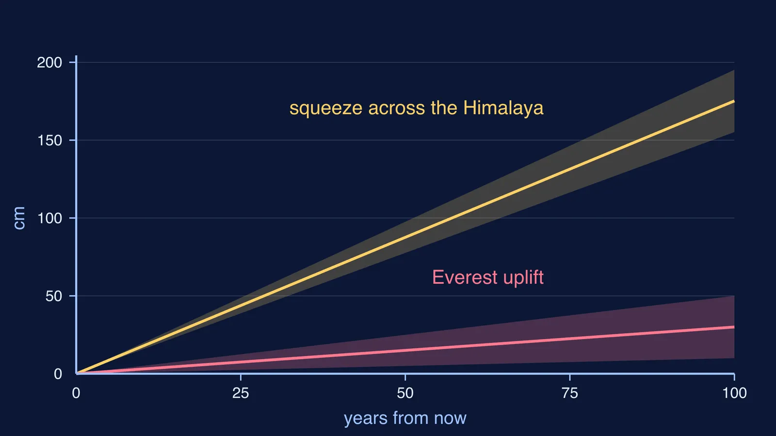
Today the speed is measured with GPS receivers fixed to bedrock. Roger Bilham's Nepal GPS page at the University of Colorado reports that India moves north-east at 58 mm a year while southern Tibet moves north-east at 36 mm a year, with the two converging at about 22 ± 3 mm a year. An earlier GPS study in Nepal by Bilham, Kristine Larson and Jeffrey Freymueller, published in Nature in 1997, measured contraction across the Nepal Himalaya of 17.52 ± 2 mm a year.
How much of that squeeze becomes height? GPS on Everest's South Col shows the Greater Himalaya rising at 3 ± 2 mm a year. That is lower than the USGS figure. The numbers come from different methods, places and time spans, so a fair summary is a few millimetres to about a centimetre a year. Meanwhile rivers, glaciers and landslides wear the peaks down, so the height you see is uplift minus erosion.
How do fold mountains form when plates collide?
This is the plate tectonics story behind the Class 9 chapter on India's physical features, in four steps, each from the USGS account:
A sea closes. An ocean, the Tethys Sea, once separated India from Asia; as India moved north, the Tethys closed.
Neither plate is swallowed. Both continental landmasses have about the same rock density, so one plate could not be subducted under the other.
The rock goes up instead. The pressure of the colliding plates could only be relieved by thrusting skyward, contorting the collision zone into the jagged Himalayan peaks.
Stress keeps building. As long as India keeps pushing, stress builds in the crust and is released from time to time in earthquakes along faults.
Self-check: can you explain why step 2 forces step 3?
How much will Everest change in your lifetime?
Mount Everest's official height is 8,848.86 m, announced jointly by Nepal and China on 8 December 2020, as reported by The Himalayan Times. Here is a worked example using the GPS uplift rate of 3 ± 2 mm a year from Bilham's measurements and an 80-year lifetime, ignoring erosion and earthquakes:
Uplift = rate × time = 3 mm a year × 80 years = 240 mm.
Convert units: 240 mm = 24 cm.
Use the error range: at 1 mm a year you get 8 cm; at 5 mm a year you get 40 cm.
Compare: 24 cm out of 8,848.86 m is about 0.003 per cent of its height.
Now do the squeeze. At 17.52 mm a year from the 1997 Nature study, 80 years closes about 1.4 m. Over a million years it closes about 17.5 km. The USGS makes the same point for height: more than 1 cm a year is a growth rate of 10 km in a million years. Tiny yearly numbers, multiplied by geological time, build a mountain range.
If you get stuck turning this into a labelled cross-section, Fermi's AI tutor can draw the figure with you and check your understanding as it goes. For ideas that are easier to see moving than to read, the Fermi Simulation Lab has interactive simulations.
Is the rising Himalaya linked to earthquakes?
Yes. The plates do not slide smoothly. The same 1997 Nature study estimated that India slips beneath southern Tibet at about 20.5 ± 2 mm a year, but the shallow part of the fault between them stays locked, so strain builds and is released in sudden slips. The study concluded that enough strain may already exist in western Nepal for an earthquake comparable to the great 1934 Bihar-Nepal earthquake.
That is why scientists map hazard rather than forecast dates; read why earthquakes cannot be predicted, then try finding an earthquake's distance from the P and S wave time gap.