On this page
Drive from Delhi towards Udaipur and you keep meeting the same low, rocky ridges. Those are the Aravallis, and their modest height is the first clue to their age. According to Wikipedia's entry on the Aravalli Range, the range runs about 670 km from near Delhi through southern Haryana and Rajasthan to Ahmedabad in Gujarat. Its highest peak is Guru Shikhar at Mount Abu, at 1,722 m.
How old are the Aravalli hills?
The Aravalli Range is the oldest fold-mountain belt in India, dating back to the Paleoproterozoic era (Wikipedia).
Geologists date these rocks with zircon crystals, which lock in uranium that slowly decays to lead. A study by Sojen Joy, Hielke Jelsma and Gert van der Linde, presented at the 35th International Geological Congress (abstract), reads the record like this:
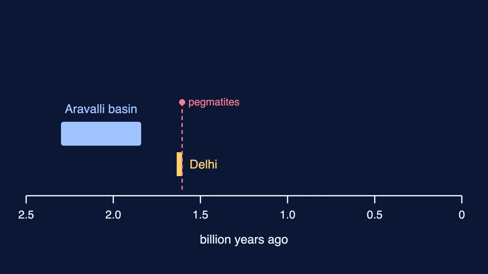
The Aravalli basin may have started to open around 2,300 million years ago, with sediments probably settling in it until about 1,840 million years ago.
The youngest zircon in the Delhi Supergroup rocks is 1,636 ± 21 million years old, so those layers were laid down after that.
Pegmatite veins that cut through both rock groups crystallised about 1,605 ± 23 million years ago, so the Delhi layers were already in place by then.
The gneiss basement beneath both groups is older, about 3,340 to 2,500 million years.
A Down To Earth article quotes the writer Pranay Lal: building these mountains took nearly two billion years, from 3.2 to 1.2 billion years ago. The fair short answer: the main Aravalli and Delhi rock layers were laid down roughly 2.3 to 1.6 billion years ago, on an older basement, and the range rose in Precambrian mountain-building.
Why are the Aravallis so low if they are fold mountains?
Fold mountains rise when two pieces of crust push together and the rock between them buckles upward. The Wikipedia geology section notes that the Aravallis were once extremely high but have worn down almost completely over millions of years of weathering. They stopped growing because the upward thrust from the plates below them stopped, while the young Himalayas are still rising.
A mountain's height is a contest between uplift and erosion:
Weathering breaks rock apart: heat and cold crack the surface, and rain dissolves some minerals.
Erosion carries the pieces away, through rain, streams, wind and gravity.
Uplift replaces what is lost, but only while the crust is still being squeezed.
Take away step 3 for hundreds of millions of years and only steps 1 and 2 remain: peaks round off and ridges split into separate hills.
Even a young range cannot grow forever, because the rock at its base can only carry so much weight. We worked through that estimate in how tall a mountain can get before its base gives way. If stress, pressure or the elastic limit feel shaky, the Fermi Concept Library gives each one its own lesson.
Do the Aravallis really stop the Thar Desert spreading?
They used to. Down To Earth quotes a 2017 Wildlife Institute of India study: the forested Aravallis once checked the Thar's spread towards eastern Rajasthan, the Indo-Gangetic plains, Haryana and western Uttar Pradesh, but the degraded forests no longer act as an effective green barrier (Down To Earth).
The same study, reading remotely sensed data from 1972-75 to 2005-07, identified twelve gaps in the range, from the Magra hills in Ajmer to the Khetri-Madhogarh hills in Jhunjhunu and the northernmost hillocks of Mahendragarh. Through these gaps, it said, the desert is migrating towards Haryana.
The government's response, in a Ministry of Environment, Forest and Climate Change release of 25 March 2023, is the Aravalli Green Wall Project: greening a 5 km buffer around the hills in Haryana, Rajasthan, Gujarat and Delhi, where the Aravalli landscape spans over 6 million hectares. One stated aim is to prevent the eastward expansion of the Thar Desert with green barriers against soil erosion, desertification and dust storms.
How can you tell an old mountain range from a young one?
Compare the Aravallis with the Himalayas:
Height: low, modest hills versus far higher, snow-capped peaks.
Shape: rounded, broken hills versus sharp, jagged ridges.
Growth: no longer rising versus still being pushed up.
Ice and rivers: no glaciers left at work versus glaciers still carving valleys, which you can read about in why Himalayan glaciers are shrinking.
Why are the Aravallis called old fold mountains?
If a geography paper asks this for 3 marks, you can write:
The Aravallis formed by folding in the Precambrian; most of their rock layers were laid down about 2.3 to 1.6 billion years ago.
Uplift stopped long ago, so weathering and erosion have worn them into low, broken hills.
The Himalayas are young fold mountains that are still rising, which is why they are much higher.
If geography revision keeps slipping down your list, Fermi's AI tutor can work out what you already know and build a plan for the session, so you start with a clear next step.