
On this page
Both Class 12 geography textbooks have a Chapter 7 called Transport and Communication, and the CBSE 2026-27 syllabus keeps both: one on world routes, one on India's networks. Here is what each covers, its map items, and practice questions.
Which Transport and Communication chapter is in the 2026-27 syllabus?
The CBSE Geography curriculum for 2026-27 lists both:
Fundamentals of Human Geography, Chapter 7: roads, trans-continental railways, sea routes, shipping canals, inland waterways, air routes, pipelines, satellites and the internet.
India: People and Economy, Chapter 7: roads, railways, pipelines, waterways, air transport, and personal and mass communication.
Neither chapter has its own mark figure. In the first book, Chapters 4 to 8 share 19 marks, and world map work carries a separate 5. In the second, Chapter 7 shares 7 marks with International Trade. The 2026-27 sample paper draws on both chapters. It has a 1-mark national waterways question, a 3-mark source-based canal question, and world-map items for airports, a canal and a waterway.
What does the world chapter cover?
Transport is a service for carrying people and goods over land, water and air (NCERT Fundamentals of Human Geography, Chapter 7, Reprint 2026-27). A transport network is made of places (nodes) joined by routes (links). Roads suit short distances and door-to-door delivery, railways bulky goods over long distances, ships trade between countries, and aircraft light, valuable or perishable goods.
Key facts:
Trans-continental railways: the Trans-Siberian runs from St Petersburg to Vladivostok, a distance of 9,332 km. The Trans-Canadian runs 7,050 km from Halifax to Vancouver. The Australian line runs from Perth to Sydney.
Sea routes: the Northern Atlantic route, called the Big Trunk Route, carries one fourth of the world's foreign trade.
Canals: the Suez Canal (1869) is a sea-level canal without locks, about 160 km long. The Panama Canal is about 72 km long, uses six locks, and shortens the sea distance from New York to San Francisco by 13,000 km.
Pipelines: the Big Inch pipeline takes petroleum from Gulf of Mexico oil wells to the US north-east.
Communication: a satellite link costs the same over 5,000 km as over 500 km. The chapter counts about 5.4 billion internet users in 2023.
What does the India chapter add?
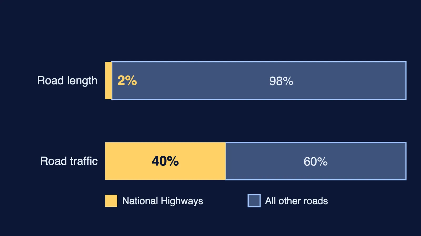
India has about 62.16 lakh km of roads (NCERT India: People and Economy, Chapter 7, Reprint 2026-27). National Highways make up only about 2 per cent of that length, yet they carry 40 per cent of road traffic.
Road projects: the Golden Quadrilateral is a 5,846 km corridor linking Delhi, Mumbai, Chennai and Kolkata. The North-South corridor (4,076 km) runs from Srinagar to Kanniyakumari, and the East-West corridor (3,640 km) runs from Silchar to Porbandar. The Border Roads Organisation was set up in May 1960.
Railways: India's first line opened in 1853 and ran 34 km from Bombay to Thane. The network is split into 17 zones. Broad gauge is 1.676 m wide. The 760 km Konkan Railway (1998) links Roha and Mangalore.
Water: NW 1 runs 1,620 km from Prayagraj to Haldia. The National Waterways Act, 2016 declared 111 national waterways. Ocean routes carry about 95 per cent of India's foreign trade by volume.
Pipelines: Oil India built a 1,157 km line from Naharkatiya to Barauni. GAIL's Hazira-Vijaipur-Jagdishpur gas pipeline is 1,700 km long.
Media: radio began in 1923. INSAT (1983) serves telecommunication and weather; IRS serves remote sensing.
Which map items come from this chapter?
The world-map list in the curriculum gives the terminal stations of the three trans-continental railways. It also lists major sea ports, airports on each continent, and four waterways: the Suez Canal, the Panama Canal, the Rhine and the St Lawrence Seaway. Copy the full list from the curriculum. The India-map list gives "Nil" for this chapter, and the Indian ports and airports belong to International Trade. Our guide to International Trade in Class 12 geography covers those ports. For the unit's other world-map items, see Primary Activities.
What practice questions can you try?
Our own sample-paper-style questions:
(1 mark) Which waterway carries heavy cargo from Rotterdam to Basel? *(Rhine)*
(3 marks) A shipper sending cargo from London to Mumbai can use the Suez Canal or go round the Cape of Good Hope. Give one advantage of the Suez route, and one reason a ship might still take the Cape route. *(Shorter distance and time; the Suez tolls are heavy, so the Cape route can be cheaper when delay does not matter.)*
(3 marks) Compare the Big Inch and the Hazira-Vijaipur-Jagdishpur pipelines: what each carries, and between which areas.
(5 marks) Why is India's railway network divided into zones? Describe three changes in Indian rail transport since Independence. *(Size strains central management; gauge conversion, electric engines, metro, Konkan Railway.)*
After the questions, mark the railway terminals, four waterways and three airports on a blank outline from memory.
If a science subject is where you do not know where to start, Fermi's AI tutor can work out what you already know and build a plan for the session.