
On this page
India's Urban Landscape is Chapter 7 of the new NCERT book Exploring Society: India and Beyond, Part 2 (code hees2, First Edition June 2026), in Theme E, Economic Life Around Us.
CBSE publishes no separate 2026-27 curriculum for Classes 6 to 8, which follow the NCERT book. The chapter is assessed by the school, so there are no marks or weightages to quote.
What is India's Urban Landscape Class 8 about?
The chapter asks how cities become economic centres, how urbanisation changes lives, what challenges cities face and how planning helps. It starts from India's urban past, from Harappan Dholavira to Varanasi and Ujjain, linking back to the theme Tapestry of the Past.
In the book, urban areas have many people, varied jobs, government offices and developed transport, run by elected local bodies; rural areas have fewer people, more farm work and gram panchayats.
The definition of urban varies by country, according to the NCERT chapter: the threshold is a population of 220 in Denmark, 50,000 in Japan and 5,000 in India.
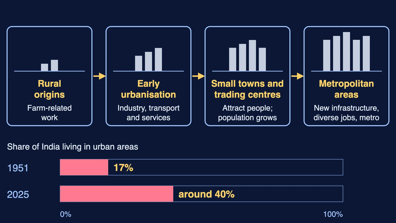
By the same chapter, India's urban share was 17 per cent in 1951 and around 40 per cent in 2025.
How do cities become centres of economic activity?
The book traces urbanisation as a gradual shift: farm work gives way to small-scale industries, transport and services; small towns and trading centres emerge; they draw people from other areas; then new infrastructure and a wider range of jobs follow as cities expand into metropolitan areas, as the diagram above shows.
Case studies show different engines of growth:
Resources: Sakchi, a village near iron ore, became the site of Asia's first steel plant and was renamed Jamshedpur in 1919.
Location and finance: Mumbai's coast made it a port, and the Bombay Stock Exchange (1875) made it the financial capital.
Clusters: Bengaluru grew as an IT hub where firms, start-ups and colleges sit close together.
Crafts: smaller centres specialise, such as Moradabad in brass and Channapatna in wooden toys.
Heritage and pilgrimage: visitors to Agra, Amritsar and Varanasi support hotels, transport and vendors.
Cities are cultural hubs too: the book cites Kolkata's Durga Puja, on UNESCO's Intangible Cultural Heritage list since 2021, and Mumbai's vada pav, popular with mill workers.
How do you calculate population density?
The book defines population density as the total population of a region divided by its area in square kilometres. Here is a worked example with made-up places.
Navapur, a fictional town, has 2,88,000 people living on 32 sq km. Density = 2,88,000 ÷ 32 = 9,000 people per sq km.
Kheri, a fictional village, has 3,150 people on 4.5 sq km. Density = 3,150 ÷ 4.5 = 700 people per sq km.
Compare: 9,000 ÷ 700 ≈ 12.9, so Navapur is about 13 times as densely populated as Kheri.
Link to the definition: in India a place counts as urban once its population exceeds 5,000, per the book. Kheri has 3,150 people, so on that measure it is not urban.
For scale, the chapter puts Singapore at over 8,000 people per sq km. For more density practice from the older book, see our Human Resources Class 8 guide.
What challenges do cities face, and how can planning help?
Rapid growth strains housing, water, roads and energy. The book lists slums, traffic jams, waste, flooding, heat islands, lost green spaces and poor air; the NCR often records AQI above 400, against a safe limit of 50.
The book notes that slum dwellers support cities through informal work, and it mentions the Pradhan Mantri Awas Yojana among government efforts on urban housing. (A note on spelling: the book prints "Aawaas"; the scheme's official website spells it "Awas".) It also describes communities reviving Bengaluru's lakes, which fell from around 1,000 to about 200.
The chapter offers two planning models:
Jaipur (1727): Vidyadhar Bhattacharya laid out a grid of blocks with wide streets, nine public squares and pink sandstone buildings along the main streets.
Singapore: a Concept Plan looking up to 40 years ahead, a Master Plan revised every 5 years, mixed-use areas and linked public transport.
Indian examples include Ahmedabad's Sabarmati Riverfront and Gangtok's pedestrian-only M.G. Road. Curious about planning as a career? See our Bachelor of Planning guide.
Practice questions for India's Urban Landscape
Our own questions; mark labels are our suggestion.
(1 mark) A settlement has 4,600 people. By the figure the book gives for India, is it urban?
(3 marks) A fictional town has 1,26,000 people on 18 sq km. Find its density and compare it with the book's figure for Singapore. (Answer: 7,000 per sq km, lower than Singapore's 8,000-plus.)
(3 marks) Using one city each, explain how natural resources and location helped a city grow.
(5 marks) Choose two urban challenges from the chapter. Suggest one planning measure for each, drawing on Jaipur or Singapore.
Not sure where to begin your revision? Fermi's AI tutor works out what you already know and builds a plan for the session.