
On this page
Drainage System is Chapter 3 of NCERT's India: Physical Environment. This guide turns its names and numbers into comparisons you can reason from, with a map drill and practice questions we wrote.
What does the 2026-27 CBSE syllabus include?
The CBSE 2026-27 Geography curriculum keeps drainage patterns; basin, catchment and watershed; the Himalayan and Peninsular systems; and usability of river water (river linking, problems, pollution). The chapter has no marks of its own: it shares Unit II's 13 marks with Structure and Physiography. Map work for the book is a separate 5 marks.
The chapter's map list has 14 rivers, six lakes (Wular, Sambhar, Chilika, Kolleru, Pulicat, Vembanad) and five straits, gulfs and the Rann, from Palk Strait to the Gulf of Khambat.
What are drainage, basins and watersheds?
All definitions and figures in this section are from the NCERT chapter (2026-27 reprint).
Drainage means water moving along clearly defined channels; the whole network of those channels forms a drainage system.
The area a river collects water from is its catchment area, and the land a river and all its tributaries drain together is a drainage basin.
The line between two basins is the watershed; small catchments are also called watersheds.
Major basins have a catchment above 20,000 sq. km (14 basins), medium basins 2,000-20,000 sq. km (44 basins), and minor basins under 2,000 sq. km.
About 77 per cent of the drainage area drains to the Bay of Bengal and 23 per cent to the Arabian Sea, separated by the Delhi ridge, the Aravalis and the Sahyadris.
Learn the patterns as shapes: dendritic like tree branches (northern plain rivers); radial outward from a hill (Amarkantak); trellis, parallel tributaries joined at right angles; centripetal, inward into a lake or depression.
How are Himalayan rivers different from Peninsular rivers?
From the NCERT chapter, side by side:
Flow: Himalayan rivers are fed by snowmelt and rain, so they are perennial. Peninsular rivers are mostly non-perennial.
Valleys: Himalayan rivers cut gorges and V-shaped valleys; Peninsular rivers have broad, shallow, largely graded valleys.
Course: Himalayan rivers meander and shift course on the plains (the Kosi, the "sorrow of Bihar"). Peninsular rivers have fixed courses without meanders.
Age: the Peninsular system is older.
Direction: most Peninsular rivers flow west to east. The Narmada and Tapi flow west through rift valleys, which is why they lack deltas.
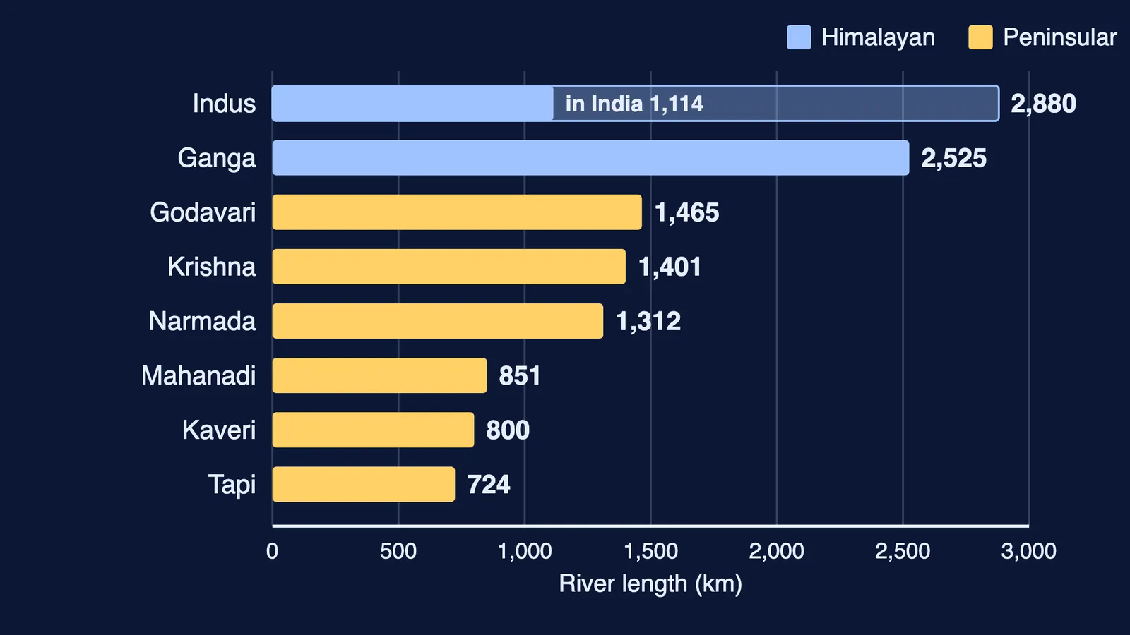
The hero chart above uses NCERT's lengths: Indus 2,880 km (1,114 km in India), Ganga 2,525 km, Godavari 1,465 km, Krishna 1,401 km, Narmada about 1,312 km, Mahanadi 851 km, Kaveri 800 km and Tapi 724 km.
What should you know about the Indus, Ganga and Brahmaputra?
Facts below are from the NCERT chapter.
Indus: rises near Bokhar Chu in Tibet; its basin covers 11,65,000 sq. km. The Panjnad (Satluj, Beas, Ravi, Chenab, Jhelum) joins it above Mithankot; the Chenab is its largest tributary.
Ganga: the Bhagirathi rises at Gaumukh and meets the Alaknanda at Devprayag. The basin covers about 8.6 lakh sq. km in India. The Yamuna is its longest tributary; the Son its major right-bank one.
Brahmaputra: rises in the Chemayungdung glacier, flows about 1,200 km east through Tibet as the Tsangpo, emerges from the foothills as the Siang or Dihang, enters India west of Sadiya, and spends 750 km in the Assam valley. It is known for floods, channel shifting and bank erosion.
How these rivers build floodplains and deltas is in our guide to landforms and their evolution; the plain they built is in India's location and physiography.
How should you practise map work for this chapter?
Four days, 20 minutes each, on an outline political map of India:
Day 1: Indus, Satluj, Ganga, Yamuna and Brahmaputra, with flow arrows.
Day 2: east-flowing Peninsular rivers, Chambal and Damodar.
Day 3: Narmada, Tapti and Luni, then the six lakes.
Day 4: the straits, gulfs and Rann, then all 14 rivers from memory.
Check against Figure 3.2 and correct in another colour.
Practice questions for Drainage System
Name the water divide between the Arabian Sea and Bay of Bengal drainage. (1 mark)
Give one reason the Narmada forms an estuary, not a delta. (1 mark)
A district wants a planning unit smaller than a river basin for soil and water work. Name the unit and explain why NCERT treats such units as good planning regions. (3 marks)
A river's tributaries flow outward from a central dome. Name the pattern and one Indian example. (2 marks)
Compare the Ganga and Godavari on source, length, flow regime and mouth. (5 marks)
A strong answer to question 5 uses NCERT's figures: Gaumukh versus Nasik, 2,525 km versus 1,465 km, a snow-and-rain-fed Himalayan river versus a Peninsular one.
If a question like the Kaveri's year-round flow stumps you, Fermi's AI tutor can work out what you already know and build a plan for the session. Start with Day 1 of the map drill tonight.