
On this page
Ibrāhīm ibn Yaḥyā al-Zarqālī, known in Latin Europe as Arzachel, was born near Toledo and trained as a metalsmith before becoming an instrument maker, according to historian Julio Samsó in Inference. He joined the astronomers gathered by the judge Ṣāʽid al-Andalusī, and with a colleague, ʽAlī ibn Khalaf, made astrolabes that did not depend on latitude.
Why did an ordinary astrolabe need a plate for each latitude?
An astrolabe is a flat model of the sky. To flatten a sphere, makers used stereographic projection. The standard method projects the celestial sphere onto the plane of the equator from the south celestial pole, as the Museo Galileo's guide to projections explains.
Everyone shares the star map, but not the horizon: its curve on the plate changes with your latitude. A standard astrolabe therefore takes measurements using disks made separately for each latitude, as a study of the zarqāliyya in Nazariyat puts it. Without the right plate, slow calculations gave only approximate results, Samsó notes (Inference).
How does Al-Zarqali's universal astrolabe work?
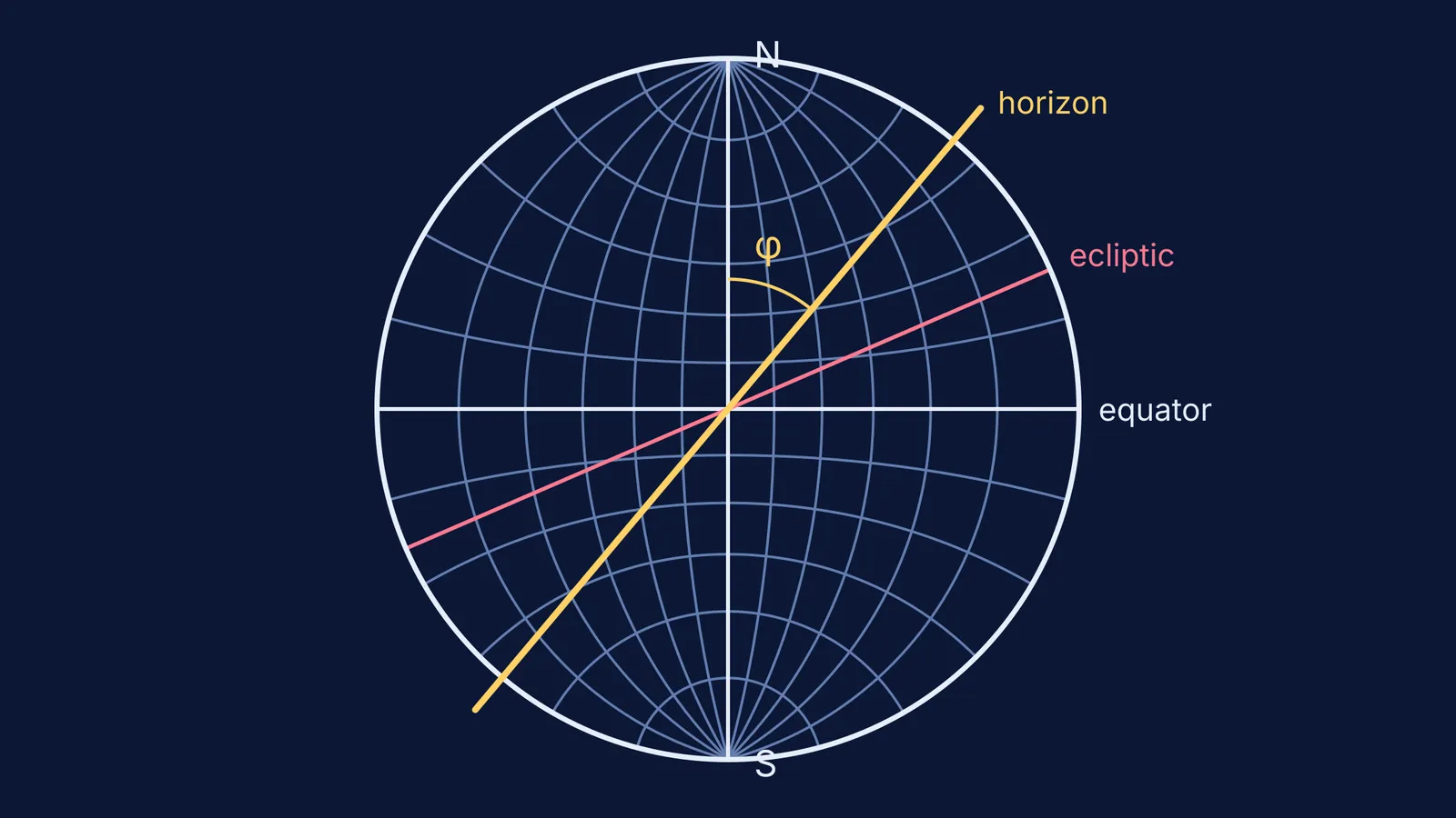
Al-Zarqali changed the point of view. His equinoctial projection maps the sky onto the plane of the solstitial colure, the great circle through both celestial poles and the solstices, and the projection point is the equinox, where the ecliptic crosses the equator (Museo Galileo).
Any great circle that passes through the equinox becomes a straight line on the plate. The equator, the ecliptic and the horizon of the moment when the equinox is rising or setting all pass through that point, so all three become straight diameters. A horizon at any latitude is just a diameter turned to a different angle. One pivoting ruler can play the horizon for every place on Earth.
The Nazariyat authors describe this plate, called the zarqāliyya in Arabic and ṣafīḥa (saphea) in the West, as one that enables measurement for any latitude (Nazariyat).
Try it: read the saphea for two latitudes
The rim of the saphea is the solstitial colure drawn at true scale, so angles along the rim can be read directly. Draw a circle, a vertical diameter (the polar axis, N at the top) and a horizontal diameter (the equator). Then:
Choose a latitude, φ. We will use 40° and then 20°.
Turn a ruler through the centre so that it makes an angle φ with the polar axis. This ruler is your horizon.
Read the rim: from where the ruler meets the rim to N is φ, so the pole stands φ above your horizon. At 40°, the pole is 40° up.
Read the rim again: from the ruler to the equator's end is 90° − φ. That is how high the equator crosses your meridian, which is where the Sun sits at noon on an equinox. At 40°, that is 50°; at 20°, it is 70°.
Change φ and repeat: no new plate, only a new ruler angle.
To picture it in 3D, the Fermi Simulation Lab has interactive simulations for ideas that are easier to see than to read, and you can compare with our post on predicting day length across latitudes with a simulation.
What were the Toledan Tables?
Ṣāʽid's group had begun making observations by at least the early 1050s, leading to the compilation of the Toledan Tables, according to Samsó. The tables were adapted to the coordinates of Toledo using tabular data from the earlier zījes (astronomical handbooks) of al-Khwārizmī and al-Battānī.
They survive in three Latin translations or adaptations, one attributed to Gerard of Cremona, and in a Greek translation made around 1330 to 1340 (Inference). More than 128 manuscripts of these translations have survived, which Samsó reads as a sign of their success across Europe.
Al-Zarqali also found that the solar apogee, the point where the Sun is farthest from Earth, has a motion of its own, faster than that of the fixed stars. Samsó gives his rate as 1° in 279 years, close to the modern value of 1° in a little more than 310 years (Inference). After his patrons died, Ṣāʽid in 1070 and al-Ma'mūn in 1075, Al-Zarqali left Toledo for Córdoba, either under the next ruler or after Alfonso VI of Castile took the city in 1085.
What can a student learn from Arzachel?
He did not build a bigger box of plates. He moved the point of projection until the hard part, the horizon, became a straight line. Choosing where to stand so the problem gets simpler is a habit you use in physics too, such as taking axes along an incline.
If the spherical geometry behind this is a gap for you, the Fermi Concept Library gives every concept in physics and mathematics its own lesson. For the trigonometry that made such tables possible, read how Abu al-Wafa built trigonometry with the tangent function, and for the Eastern astronomy Toledo built on, see how Al-Farghani's Elements of Astronomy measured the cosmos.