
On this page
A thousand years ago, near Rayy (close to today's Tehran), the astronomer Abu Mahmud al-Khujandi turned a building into a measuring instrument. He wanted one number: how far Earth's axis is tilted. That angle, the obliquity of the ecliptic, is why we have seasons. His method needs only school trigonometry, and you can repeat it with a stick.
What was al-Khujandi's Fakhri sextant?
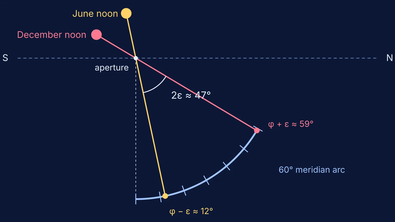
According to the Biographical Encyclopedia of Astronomers entry by Glen Van Brummelen, the instrument was named al-suds al-Fakhri after its sponsor, the Buyid ruler Fakhr al-Dawla. It was 60° of a meridian arc about 43 m in diameter, built at and below ground level. A small hole in the roof let a cone of sunlight fall onto the curved scale. A circle marked with crosshatched lines was placed on the patch of light to find its centre.
The arc ran along the meridian, the north–south line, so the noon Sun always landed somewhere on the scale (Wikipedia, Sextant (astronomy))). The MacTutor biography from the University of St Andrews says its scale showed seconds of arc, a level of accuracy never attempted before.
Why did the sextant have to be so big?
On a bigger circle, each degree takes up more length on the scale. Here is the arithmetic, using the 43 m diameter from the encyclopedia entry:
The radius is about 21.5 m, so the circumference is 2π × 21.5 ≈ 135 m.
One degree is 1/360 of that, about 375 mm of scale.
One arcminute (1/60 of a degree) is about 6 mm. Ten arcseconds is about 1 mm.
On a school protractor with a 7.5 cm radius, one degree is only about 1.3 mm long, so a single arcminute is far too small to see.
When each degree is a long stretch of scale, the fuzzy edge of the Sun's image matters much less.
How do you measure Earth's tilt from the noon Sun?
At noon on the June solstice the Sun stands highest in a northern-hemisphere sky. At the December solstice it stands lowest. If φ is your latitude and ε is the tilt, the noon altitudes are:
June: altitude = 90° − φ + ε
December: altitude = 90° − φ − ε
Subtract the second from the first and φ cancels, leaving 2ε. Add them and ε cancels, leaving your latitude. Two readings give you two unknowns (Wikipedia, Sextant (astronomy))).
Al-Khujandi observed the Sun crossing the meridian on 16 and 17 June 994 and on 14 and 17 December 994 (MacTutor). He found ε = 23°32′19″, and 35°34′38″ for the latitude of Rayy, which was accurate to within one arcminute (Van Brummelen, BEA).
You can work backwards from his two results to the angles he must have read. The June noon altitude comes to 90° − 35°34′38″ + 23°32′19″ = 77°57′41″. The December one is 30°53′03″. Half their difference, 47°04′38″ ÷ 2, gives back his 23°32′19″. In the sextant both sunbeams fall within 60° of the vertical (about 12° and 59°), which is why a sixth of a circle was enough at Rayy.
How close did al-Khujandi get?
The tilt slowly changes. Today it is about 23.44° and decreasing, and it swings between roughly 22° and 24.5° over a cycle of about 41,000 years (Wikipedia, Axial tilt). We put 994 CE into the IAU obliquity formula based on Capitaine, Wallace and Chapront (2003) and got a tilt of about 23°34′ for that year. The formula is built for recent centuries, so treat this as an estimate. It puts al-Khujandi's figure about two arcminutes too low, which matches the MacTutor assessment.
Al-Biruni blamed the building itself. He argued that it settled between the summer and winter solstices, so the hole in the roof dropped (Van Brummelen, BEA). MacTutor reports al-Biruni's estimate of the sag as about one span, caused by the weight of the instrument. Once the pinhole moves, the two readings no longer share a reference point.
Al-Khujandi also noticed something important. Earlier astronomers had found larger values: 24° from Indian astronomers and 23°51′ from Ptolemy (MacTutor). From these earlier values he concluded that the tilt is not fixed but changes over time. Al-Biruni disagreed (Van Brummelen, BEA). The tilt really is decreasing, but only by about 47″ per century (Wikipedia, Axial tilt), so much of the spread in those old values came from errors in measurement.
What can a student take from this?
Pair measurements so unknowns cancel. Subtracting the two solstice readings removes latitude.
Scale up to reduce reading error. A bigger circle spreads the same angle over more of the scale.
Check what moves between readings. For al-Khujandi it was the roof.
If the geometry of a tilted Earth is hard to picture, a family globe-and-torch activity for explaining the seasons helps. So does our simulation of how day length changes with latitude. The Fermi Simulation Lab has interactive simulations for ideas that are easier to see than to read. For the trigonometry al-Khujandi's contemporaries were building, read about Abu al-Wafa and the tangent in spherical trigonometry. You can also look up altitude, latitude and angular measure in the Fermi Concept Library.