
On this page
Two villages on the southern edge of Meghalaya's Khasi Hills are the standard textbook examples of heavy rain. In the World Meteorological Organization's records of weather and climate extremes, Mawsynram, at 1,431 m, has an average annual rainfall of 11.872 m, based on 38 years of records. The same table gives Cherrapunji the world record for 12 months of rain: 26.47 m between August 1860 and July 1861. It also holds the 48-hour record: 2.493 m on 15 and 16 June 1995.
Why do Cherrapunji and Mawsynram get so much rain?
Three things come together: a moisture supply, a wall, and the timing of the wind.
The supply. In the monsoon, warm, wet winds blow from the Bay of Bengal across the flat plains of Bangladesh, with nothing to force them up.
The wall. Using 17 years (1998–2014) of satellite radar data, Fujinami and colleagues found that when strong south-westerly winds blow across Bangladesh into the Meghalaya Plateau, they pile moist, unstable air against its southern slopes, giving frequent, intense orographic rain. When strong south-easterlies instead blow along the Gangetic Plain without meeting the plateau, sinking air holds rain back and far less falls.
The timing. From Bangladesh rain gauges and weather balloons, Terao and colleagues found that rain in north-eastern Bangladesh, at the foot of the hills, peaks between 3 and 6 am local time. They suggest a low-level wind that speeds up at night, blowing harder against the hills, as a likely cause.
A study of Cherrapunji and Mawsynram rainfall by Murata and colleagues traced the day-to-day swings to large weather disturbances that recur every 10 to 20 days, interacting with the hills.
What is orographic lift, and why does rising air make rain?
Orographic lift happens when wind meets rising ground and the air is forced upward. Higher up the pressure is lower, so the rising air expands, and air that expands without taking in heat cools. That is an adiabatic process, the same one you meet in Class 11 physics.
According to the open textbook Atmospheric Processes and Phenomena on LibreTexts, dry rising air cools at 9.8 °C per kilometre. Once the air is saturated, condensing vapour releases latent heat, so the air cools more slowly; the same source uses 4.5 °C per kilometre for this moist rate, treating it as constant for simplicity. Cooler air holds less vapour, so as saturated air keeps rising, more vapour condenses into droplets that can grow into rain. Our post on how rising, cooling air forms a cloud covers that step in more detail.
A worked example: one parcel of air up the Khasi Hills
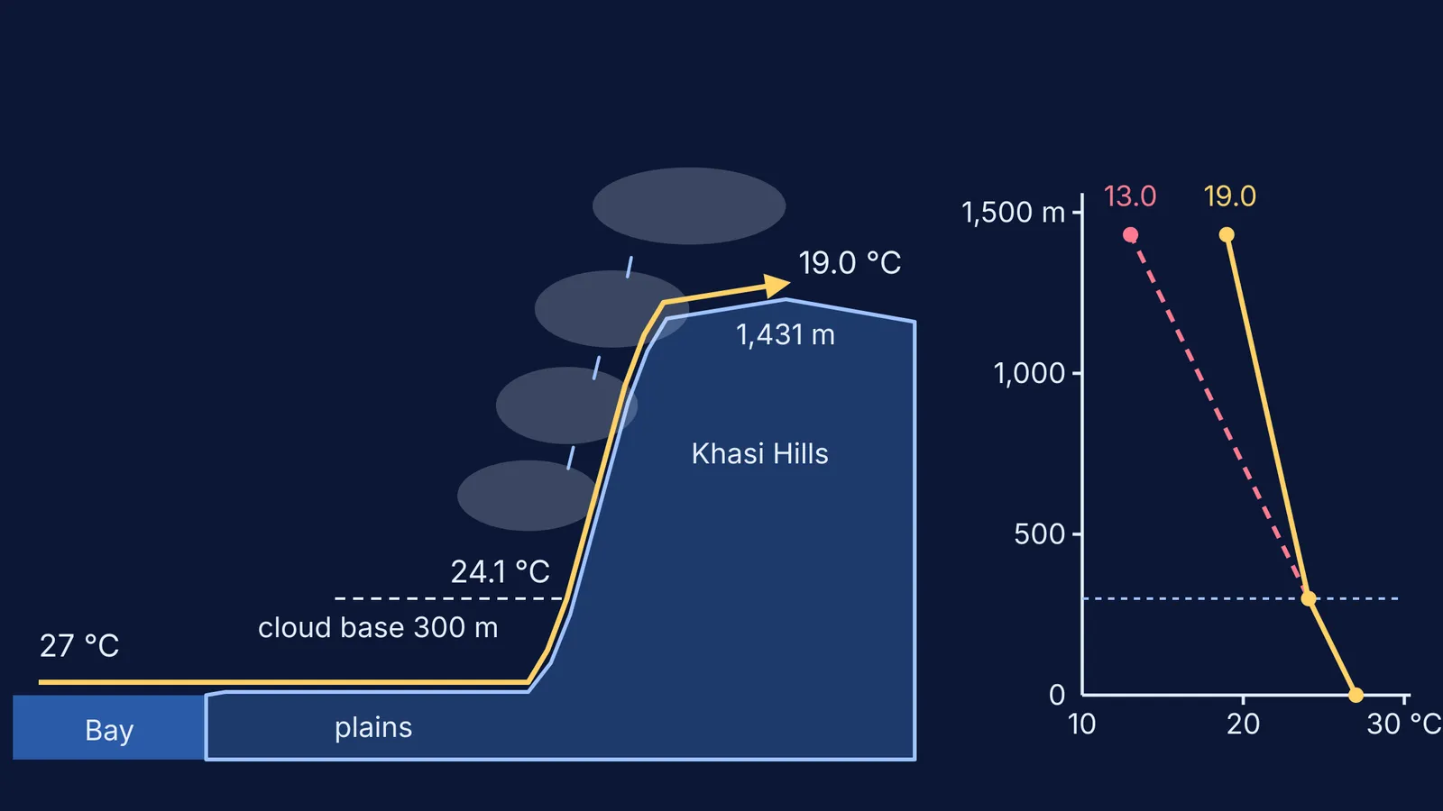
Use the two LibreTexts lapse rates and the WMO's elevation for Mawsynram. The starting numbers are made up for the exercise, not measured. A parcel leaves the plains at 27 °C, and we assume it is so humid that it becomes saturated at 300 m, the cloud base.
From 0 to 300 m it is unsaturated and cools at 9.8 °C per km: 0.3 × 9.8 = 2.9 °C. It reaches the cloud base at about 24.1 °C.
From 300 m to Mawsynram's 1,431 m is 1.131 km. Saturated, it cools at 4.5 °C per km: 1.131 × 4.5 = 5.1 °C. It arrives at about 19.0 °C.
Had the air stayed dry, it would have cooled by 1.431 × 9.8 = 14.0 °C, ending at 13.0 °C.
The 6 °C gap is heat given out by vapour turning into cloud droplets: a sign that cloud is forming over the slope.
If a rising, cooling parcel is hard to picture, the Fermi Simulation Lab has interactive simulations for ideas that are easier to see than to read.
Why is the other side of the hills drier?
After crossing the hills, the air has lost much of its water and sinks. Sinking air is squeezed and warms, so clouds evaporate instead of forming. This is the rain-shadow effect. The Western Ghats show the same pattern, as explained in why Mumbai gets more rain than Pune. For where the winds come from, see what causes the Indian monsoon.
How should you write this in an exam answer?
Use this checklist for any windward-slope question:
Name the wind and its source: the monsoon from the Bay of Bengal.
Name the barrier: the steep southern face of the Khasi Hills.
Say what happens to the air: it is forced up, expands and cools adiabatically.
Say what happens to the vapour: it condenses into clouds and heavy rain on the windward side.
End with the contrast: sinking, warming air on the leeward side gives a rain shadow.
If adiabatic cooling is the shaky link in your chain, the Fermi Concept Library has a lesson for every concept in physics and chemistry. Revise it there, then redo the worked example with a different cloud base.