

On this page
You can drive from Mumbai to Pune in under three hours, yet the two cities experience entirely different monsoons. According to the India Meteorological Department, Mumbai receives about 2,502 mm of rain annually. Just across the mountains, Pune receives an average of about 822 mm. This dramatic drop in precipitation is a classic example of orographic rainfall and the rain shadow effect.
Why does Mumbai get more rain than Pune?
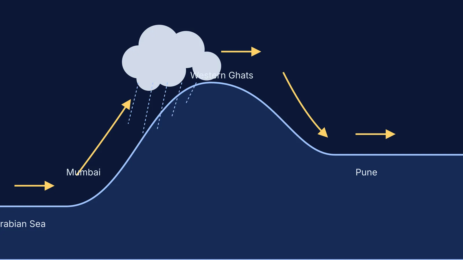
The difference comes down to geography and wind. Mumbai sits directly on the coast of the Arabian Sea, on the windward side of the Western Ghats. During the Southwest Monsoon, winds heavily laden with moisture blow in from the sea. When these winds meet the steep physical barrier of the Western Ghats, they have nowhere to go but up.
As the air is forced upwards, it expands and cools. Cold air holds less water vapour than warm air, so the moisture quickly condenses into thick clouds, dropping heavy rain over Mumbai and the western slopes. By the time the winds reach the mountain crest, they have emptied most of their water.
If visualizing how air cools as it is forced up a mountain feels difficult, the Fermi Simulation Lab provides interactive simulations for the ideas that are easier to see than to read.
What is the rain shadow effect?
Pune is located on the Deccan Plateau, at an elevation of about 570 metres, on the leeward (eastern) side of the Western Ghats. When the monsoon winds finally cross the peaks and descend towards Pune, the physics reverses.
As the air sinks, the atmospheric pressure increases, compressing and warming the air. Warmer air has a higher capacity to hold moisture. Because the air has already lost its water over Mumbai, and is now warming up, it is exceptionally dry. This descending, warming air prevents clouds from forming, creating an arid zone known as a rain shadow.
How does adiabatic cooling work?
The exact temperature changes the wind experiences are predictable rules of physics known as lapse rates.
When dry air rises, it cools at the Dry Adiabatic Lapse Rate (DALR), which is about 9.8 °C for every kilometre of elevation. However, once the air reaches its dew point and water begins to condense, latent heat is released. This heat partially offsets the cooling. From that point on, the rising air cools at the Wet Adiabatic Lapse Rate (WALR), which is roughly 5 °C per kilometre.
This slower cooling rate on the way up, combined with the faster warming rate on the way down, is why leeward cities are not only drier but often warmer than their coastal neighbours at similar latitudes. You can see similar principles of gas expansion and temperature change in other areas of physics, such as the free expansion of an ideal gas: why work and ΔU are both zero.
How does the math add up?
We can trace a parcel of air from the coast to the plateau to see these lapse rates in action. This is the exact mechanism that creates the systems described in Vilhelm Bjerknes and the physics of weather forecasting.
Start at Mumbai: A parcel of air at sea level starts at 30 °C.
Hit the dew point: The humid air rises 200 metres up the Ghats. Cooling at the DALR (9.8 °C/km), it drops about 2 °C to reach 28 °C, at which point clouds form.
Rain on the Ghats: The air rises another 600 metres to the 800-metre crest. Now cooling at the WALR (5 °C/km), it drops another 3 °C to reach 25 °C, raining heavily all the way.
Descend to Pune: The dry air crests the peak and descends 230 metres to Pune's elevation of 570 metres. Sinking and warming at the DALR (9.8 °C/km), its temperature rises by 2.3 °C.
Final state: The air arrives in Pune at 27.3 °C, stripped of its moisture and ready to absorb water rather than release it.
The heat dynamics involved in this process are intimately connected to the principles of specific heat capacity, just as they are when calculating heat in isobaric and isochoric processes: using nCpΔT and nCvΔT. The next time you travel from the coast to the plateau, you will know exactly why the clouds vanish.


