
On this page
On many December and January mornings, towns across the Indo-Gangetic Plain wake up inside a cloud. In the 24 hours to 8.30 am on 17 December 2025, the India Meteorological Department (IMD) reported visibility of 0 metres at Bareilly, Amritsar, Kanpur and Lucknow airport, with dense to very dense fog over parts of Uttar Pradesh, Punjab and Uttarakhand.
The physics behind it is the same physics that makes a cold glass of water "sweat".
What is fog, exactly?
Fog is a cloud at ground level that cuts visibility to less than 1,000 metres, according to the UK Met Office. Like a cloud, it is made of tiny water droplets suspended in the air.
IMD grades fog by how far you can see. In its 17 December 2025 bulletin, dense fog means visibility of 50 to 199 metres, and very dense fog means visibility below 50 metres.
Why does dense fog form in north India in winter?
The fog that blankets the plains is mostly radiation fog, "the most common type of fog that occurs over the Indo-Gangetic Plain", write Vinayak Sinha, a professor at IISER Mohali, and Abhishek Mishra, a scientific officer at Bihar Mausam Sewa Kendra, in 360info. It needs four ingredients, and north India in winter supplies all of them.
Long nights. In New Delhi, the shortest day of the year has 10 hours 19 minutes of daylight, against 13 hours 58 minutes at the June solstice, according to sunrise-sunset.org. That leaves more than 13 hours of darkness in which the ground loses heat and gains none from the Sun.
Clear skies. With no cloud overhead, the ground radiates its heat away, and the Met Office explains that this overnight cooling chills the air close to the surface.
Calm, stable air. A still, cold bottom layer of air keeps that chill and moisture trapped near the ground. A 2024 study in Atmospheric Chemistry and Physics by Chandrakala Bharali and colleagues lists a stable boundary layer and low temperature among the factors that control fog in the region.
Plenty of moisture. The same study names moisture "supplied by the western disturbances and irrigation activities" as a key factor. Sinha and Mishra add that irrigating the winter wheat crop "provides even more water for evaporation", on top of the ponds, rivers and canals already in the region (360info).
There is a fifth, very north-Indian ingredient: pollution. Water vapour condenses on tiny airborne particles, and the Bharali study found that in a modelled December 2017 fog event, including the feedbacks and chemistry of aerosols made fog form 1 to 2 hours earlier and last longer.
The same clear, still nights also drive cold waves in north India.
What does the dew point have to do with fog?
The dew point is "the temperature to which air must be cooled in order to reach saturation", in the words of the US National Weather Service glossary. Air at a given temperature can hold only so much water vapour. Cool it at constant moisture and its relative humidity climbs; at the dew point it reaches 100%, and any further cooling squeezes vapour out as droplets. That is condensation, the same process behind why you can see your breath on cold mornings.
How much does moist air need to cool before fog forms?
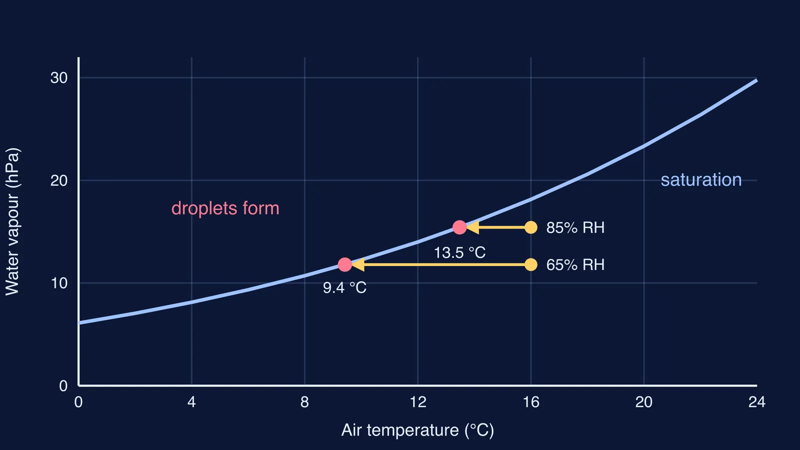
You can estimate a dew point with the Magnus formula, using the constants 17.625 and 243.04 °C from Alduchov and Eskridge (1996)035%3C0601:IMFAOS%3E2.0.CO;2), as set out in the sensortoolkit documentation. Take two illustrative evenings at 16 °C:
Over dry ground, 65% relative humidity: the dew point works out to about 9.4 °C, so the air must cool by about 6.6 °C before fog can form.
Beside a freshly irrigated wheat field, 85% relative humidity: the dew point is about 13.5 °C, so just 2.5 °C of cooling is enough.
Same temperature, same long night, but the moister air reaches saturation far sooner. That is why the extra moisture from irrigation and western disturbances matters so much.
How can you tell if tomorrow will be foggy?
Use this five-point checklist on a winter evening. The more boxes you tick, the higher the fog risk.
The forecast says clear skies overnight.
Winds are light or calm.
A western disturbance has just passed, or it has rained recently.
Your weather app shows the dew point within a few degrees of the evening temperature.
Fields around you have been watered recently, or you live near a river or canal.
Then check IMD's district-wise warnings before an early train, flight or school bus, and leave extra time. To see how those warnings are made, read how IMD forecasts the weather.
The saturation curve in the diagram above is one of those ideas that is easier to see than to read. The Fermi Simulation Lab has interactive simulations for ideas like this. To revise humidity and vapour pressure from the ground up for board exams, each concept has its own lesson in the Fermi Concept Library.
Tonight, check the dew point before bed, then look out of the window at sunrise.