
On this page
If you live in Delhi, Lucknow or Chandigarh, you know the pattern: a few grey, drizzly days, then bright, bitter mornings. That switch is the heart of a cold wave, and it comes down to Class 11 physics: heat carried by moving air, and heat lost by radiation.
What counts as a cold wave in India?
The India Meteorological Department (IMD) sets thresholds for night-time minimum temperatures in its FAQ on cold waves:
A plains station is considered only if its minimum temperature is 10°C or less; a hill station, 0°C or less.
A cold wave is a minimum 4.5°C to 6.4°C below normal; a severe cold wave is a bigger drop, 6.4°C or more below normal.
In the plains, a minimum of 4°C or less counts as a cold wave and 2°C or less as a severe cold wave, whatever the normal.
The criteria must be met at two or more stations in a meteorological sub-division for two days in a row, and the cold wave is declared on the second day.
Cold waves are dangerous: a 2016 study in Scientific Reports counted 3,264 deaths reported due to cold waves in northern India during 1978 to 1999. The same study found that Indian cold waves occur from November to February and peak in January.
What causes cold waves in north India in winter?
Cold air has to arrive from somewhere colder. Ratnam and colleagues write in Scientific Reports that winter cold waves over India "are primarily due to transport of cold air from higher latitudes". In one type of event, northwesterly winds carry it in. A 2026 study of north India in PLOS One notes that during cold waves, cold northwesterly winds blowing at 3 to 5 m/s add a wind-chill effect.
A western disturbance has to pass. A western disturbance is a cyclonic storm linked to the subtropical westerly jet that brings rain and snow to northern India, as described in a 2015 review in Reviews of Geophysics. The PLOS One study notes that cold waves are typically triggered by the passage of western disturbances and tend to intensify after the disturbance exits the region, and that atmospheric blocking can make them last longer and hit harder.
Why do clear nights get so much colder?
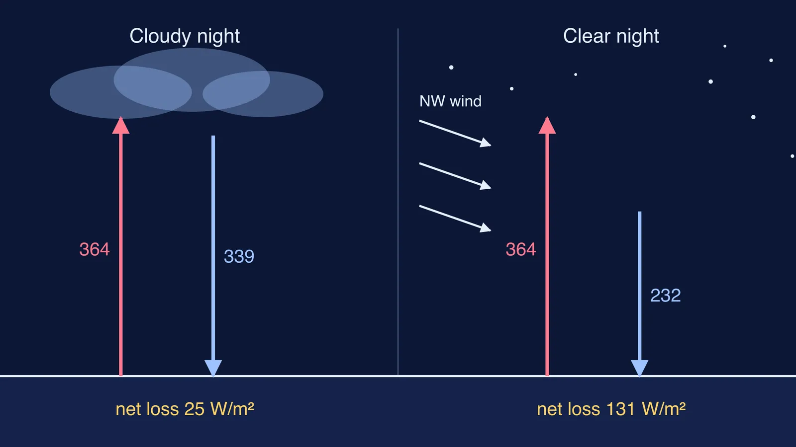
Every surface gives off heat as infrared radiation. The US National Weather Service defines radiational cooling as the net heat loss of Earth's surface to space at night, adding that it "is more pronounced when you have a clear sky". Cloud absorbs the ground's infrared and sends much of it back down; clear, dry air returns far less.
Here is a worked example using the Stefan–Boltzmann law, P/A = σT⁴, with σ = 5.670374419 × 10⁻⁸ W m⁻² K⁻⁴ (NIST). We treat everything as a perfect emitter (a simplification) and use example temperatures.
Ground at 10°C (283 K) radiates σ × 283⁴, about 364 W per square metre.
On a cloudy night, a cloud base at 5°C (278 K) sends back about 339 W/m². Net loss: about 25 W/m².
On a clear night, if the sky behaves like a body at −20°C (253 K), it sends back about 232 W/m². Net loss: about 131 W/m², roughly five times as much.
The lesson is in the fourth power: a colder-looking sky makes the ground cool much faster. For ideas like this that are easier to see than to read, the Fermi Simulation Lab has interactive simulations. If the Stefan–Boltzmann law itself is the gap, the Fermi Concept Library gives every physics concept its own lesson.
What did this look like in December 2024?
IMD's press release of 28 December 2024 shows the pattern clearly. A western disturbance lay over north Pakistan and adjoining Jammu and Kashmir, and minimum temperatures were 5°C or more above normal at a few places over Haryana-Chandigarh-Delhi and at isolated places over Punjab. In the same release, IMD forecast a 3 to 5°C fall in minimum temperatures over Northwest India over the next two days, and cold wave conditions in Punjab and Haryana-Chandigarh from 29 December to 3 January.
IMD's 22 January 2022 release had the same shape: minimums 3 to 5°C above normal over Rajasthan, Punjab and Haryana during a western disturbance, then a forecast of no significant change for two days followed by a 4 to 6°C fall over Northwest India.
How can you spot a cold wave coming?
Use this checklist with IMD's daily bulletin and its cold wave criteria:
Find the western disturbance in the weather-systems section. While it is overhead, expect cloud and milder nights.
Look for "fall in minimum temperatures" once it moves east. That often means the sky is clearing.
Run the IMD test yourself. If your city's normal minimum is 7°C and the forecast is 2°C, the departure is −5°C: a cold wave by the departure rule, and a severe cold wave by the plains rule of 2°C or less.
Prepare. The IMD FAQ advises several loose layers, keeping dry and drinking hot fluids.
Next clear, bitter morning, check the bulletin: a western disturbance has often just moved on.