On this page
Map work in Classes 3 to 5 starts with a blank world map and twelve names. Many children can recite the list but struggle to put each name in the right place, which is what a map question asks. Here is a way to learn both, with one fact for each name.
How many continents and oceans are there?
National Geographic defines a continent as one of Earth's seven main divisions of land, and lists them from largest to smallest as Asia, Africa, North America, South America, Antarctica, Europe and Australia (National Geographic Education).
The ocean is really one connected body of water that covers 71 percent of the Earth (NOAA). People name five parts of it: the Pacific, Atlantic, Indian, Arctic and Southern Oceans. NOAA calls the Southern Ocean the newest named ocean and notes that not every country agrees on its boundaries yet, so an older atlas at home may show only four.
How do you remember the seven continents in order?
Learn two lists, because a map test asks two things.
The size list answers which is largest: All Aunts Need Sweet Aam Every April gives Asia, Africa, North America, South America, Antarctica, Europe, Australia, largest to smallest.
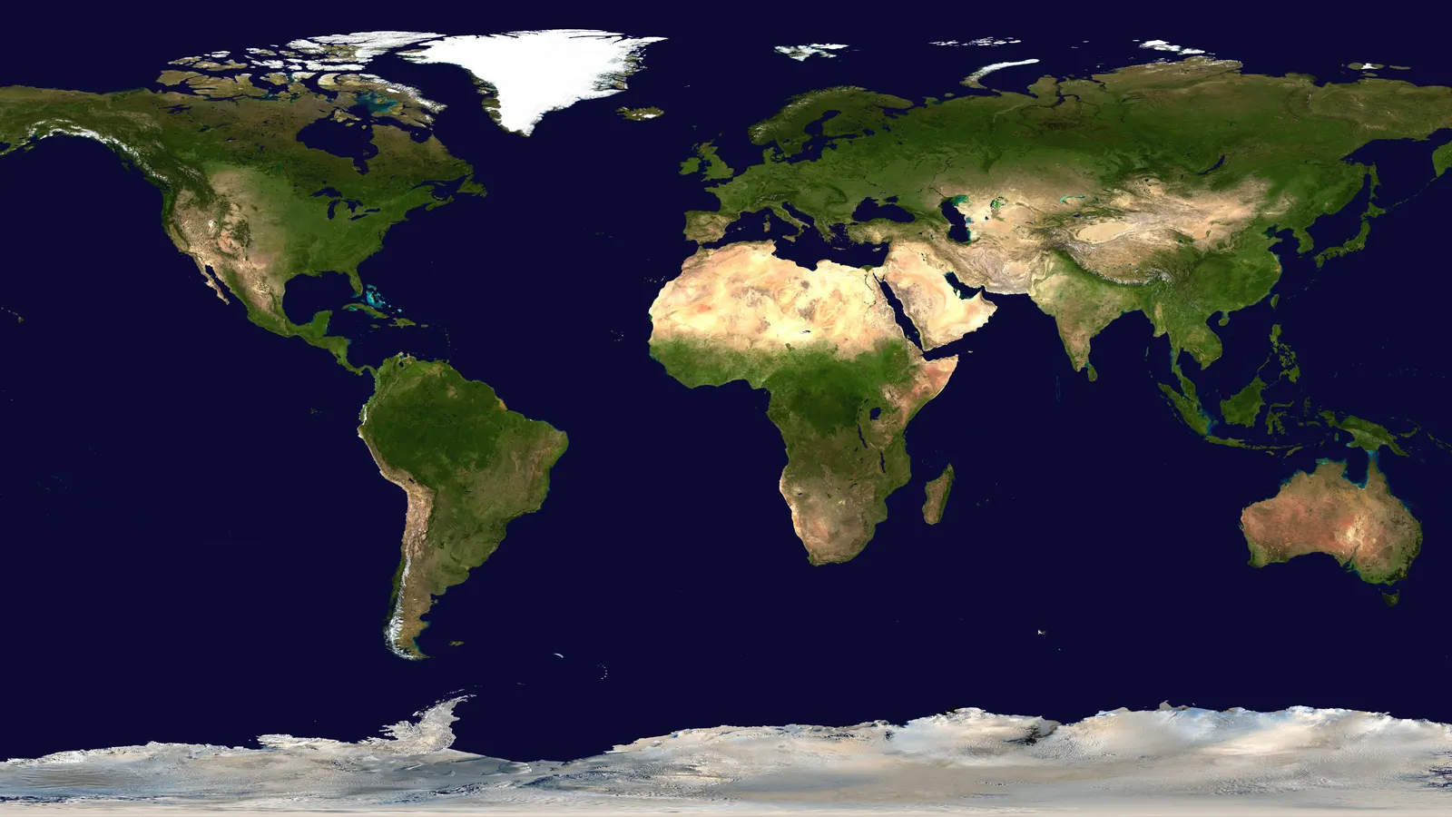
The memory map answers where each one is. Walk your finger around a world map, starting at home:
Put your finger on India. You are in Asia.
Slide west across the Arabian Sea to Africa.
Keep going west across the Atlantic to South America.
Climb north to North America.
Cross back east over the Atlantic to Europe, just above Africa.
Fly south-east past Asia to Australia.
Drop to the bottom of the map: Antarctica.
Say each name aloud as you move. After a few walks, many children can do it without looking.
Our explainer on why Greenland looks so big on maps shows the stretch.
What is one fact about each continent?
One fact per name is enough at this age. Each of these comes from National Geographic's continent guide:
Asia is the largest continent, and about 60 percent of Earth's people live there. Mount Everest, the highest point on Earth, is in Asia.
Africa is the second-largest continent. The Nile, the world's longest river, flows more than 6,560 kilometres.
North America is the third-largest. Greenland, the world's largest island, is the only place besides Antarctica that still has an ice sheet.
South America is the fourth-largest. The Amazon is the largest river in the world by volume of water.
Antarctica is almost completely covered with ice, in places 3.2 kilometres thick. It is the windiest, driest and iciest place on Earth.
Europe is the sixth-largest and holds just 7 percent of the world's land.
Australia is the smallest continent, and also the flattest.
How do you remember the five oceans?
NOAA ranks the ocean basins from largest to smallest as Pacific, Atlantic, Indian, Southern and Arctic (NOAA Ocean Service). The first letters spell PAISA, a word most Indian children already know.
Pacific: the largest and deepest, covering more than 30 percent of Earth's surface (NOAA Ocean Exploration). Its deepest point, the Challenger Deep, is about 10,935 metres deep (NOAA).
Atlantic: the second largest. The Pacific holds almost twice as much water (NOAA Ocean Exploration).
Indian: the third largest, and the one on India's coasts. Traders once crossed it using the monsoon winds, a story told in how ancient traders sailed the Indian Ocean.
Southern: the newest named ocean, stretching from the coast of Antarctica to the line of latitude at 60 degrees South (NOAA).
Arctic: the smallest, about 14 million square kilometres (NOAA Ocean Exploration).
A one-week map plan for Classes 3 to 5
Ten minutes a day, with a blank outline map printed seven times.
Day 1: do the memory-map walk together three times.
Day 2: label the seven continents from memory, then check the atlas.
Day 3: add the five oceans using PAISA.
Day 4: point to each name and say its fact.
Day 5: you call out a fact; your child points to the place.
Day 6: a fresh map, everything from memory, then check.
Day 7: your child teaches the map to someone at home.
When a label lands in the wrong place, ask instead of correcting: Which ocean did you cross to get there? Start from India and walk me there. Finding the mistake themselves gives your child the route as well as the answer.
Check facts in the textbook or an atlas, not a chatbot: our explainer on whether AI can place locations for map work shows that chatbots can misplace places on a map.
Asking before telling is also how Fermi's AI tutor works with older students: it notices where a student is stuck and decides whether to explain, ask or show.
Print the blank map tonight and start with the walk from India.