On this page
On 30 July 2025, an ISRO GSLV rocket lifted off from Satish Dhawan Space Centre in Sriharikota carrying NISAR, the NASA-ISRO Synthetic Aperture Radar satellite (NASA launch release). The same release calls it the first free-flying space mission with two radar instruments, an L-band system and an S-band system. It is also a working lesson in the waves and interference you study in Class 12.
What is the NISAR satellite?
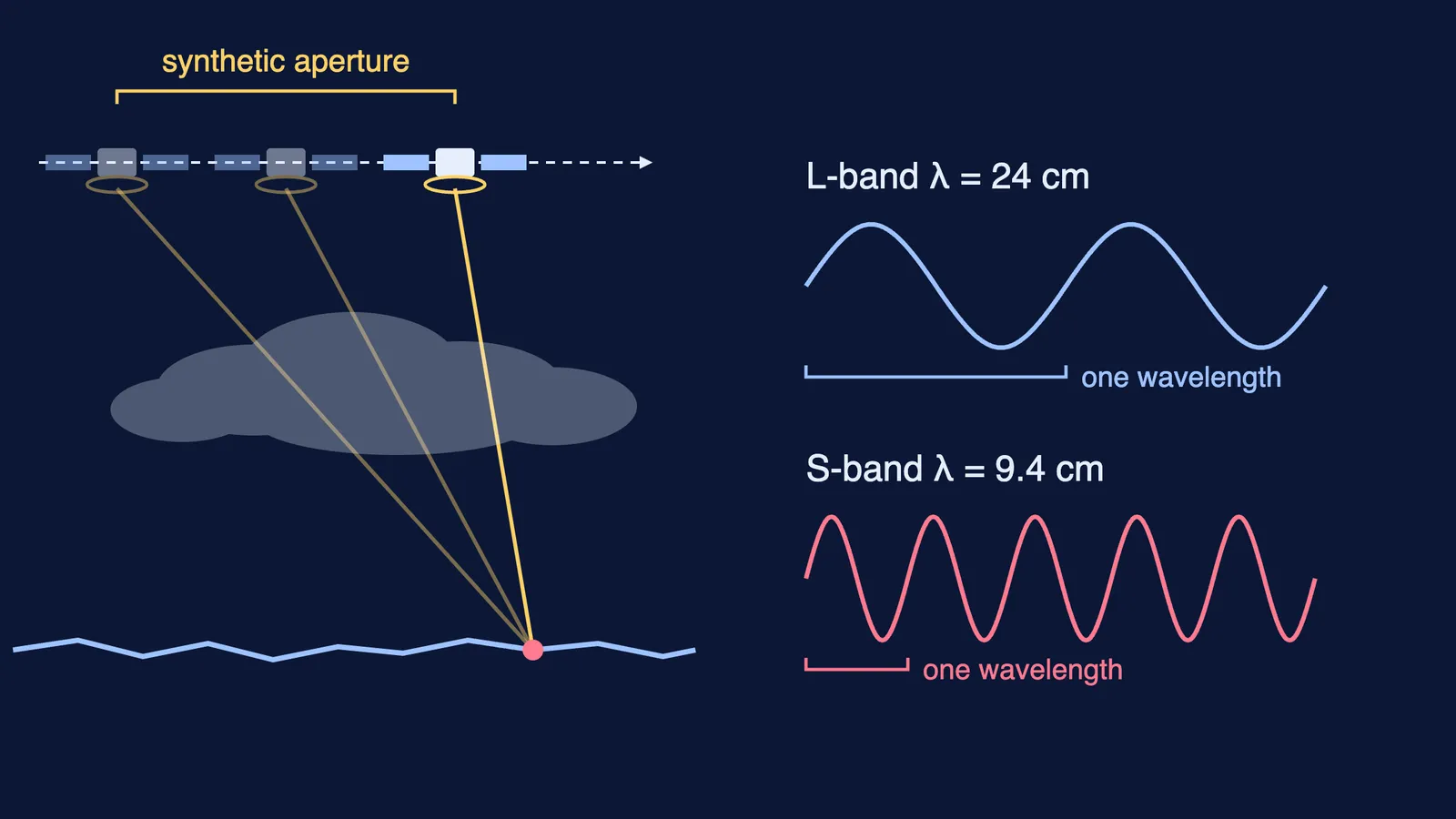
NISAR was jointly developed by NASA and the Indian Space Research Organisation (NASA). NASA's Jet Propulsion Laboratory supplied the 24 cm wavelength L-band radar and ISRO supplied the 9.4 cm wavelength S-band radar (NASA, about the satellite). Both share a 12 m antenna reflector mounted on a 9 m boom, and the satellite maps strips of ground 242 km wide (NASA, about the satellite).
NISAR orbits at 747 km and repeats its exact ground track every 12 days, over a baseline mission of 3 years (NASA mission overview). Its data is free and open: L-band data through the Alaska Satellite Facility, and S-band data plus L-band data over India through ISRO's Bhoonidhi portal (NASA mission overview).
How does a radar satellite see through clouds?
A camera records sunlight bounced off the ground, so clouds and night stop it. A radar sends out its own microwave pulses and records the echoes. NASA's Earthdata guide explains that radar uses wavelengths at the centimetre to metre scale, which lets it image landforms covered by clouds or under a dense canopy of trees, night or day (NASA Earthdata). NASA says NISAR can monitor the surface during storms, in darkness and in light (NASA).
That matters in India, where the ground you most want to watch during a monsoon flood or landslide is often under cloud.
What does synthetic aperture radar mean?
A bigger antenna gives a sharper image, but you cannot launch one kilometres long. Synthetic aperture radar uses the satellite's motion instead: NASA's example is a 10 m antenna that, by combining echoes along its orbit, behaves like a virtual 10 km antenna in the direction of flight (NASA, get to know SAR). NISAR's radar resolution is 3 to 10 m, depending on the acquisition mode (NASA mission overview).
Why does NISAR use two wavelengths?
What a radar wave bounces off depends on how big things are compared with its wavelength. NASA notes that a longer wavelength is more likely to scatter off tree trunks than leaves (NASA, get to know SAR). Earthdata adds that a 3 cm X-band signal barely enters a broadleaf forest, while an L-band signal penetrates more deeply through the canopy (NASA Earthdata). So the two radars see different layers of the same scene.
According to NASA, NISAR measures:
ground motion from earthquakes, volcanoes, landslides and sinking land (NASA, interferometry)
the flow of glaciers and ice sheets, and changes in crops and ecosystems (NASA NISAR)
soil moisture and forest biomass, where the L-band radar excels (NASA)
shorelines and oil spills on water (NASA, science behind the mission)
How can a satellite 747 km up measure millimetres?
By interference. InSAR (interferometric SAR) compares the phase of the echoes from two or more passes over the same place (NASA, interferometry). If the ground moves a distance d towards the satellite, the wave's round trip shortens by 2d, so the phase changes by 4πd/λ. One full colour cycle in the image, called a fringe, means a phase change of 2π, which is a ground shift of λ/2.
Work it through with NISAR's numbers:
L-band: λ = 24 cm, so one fringe = 24/2 = 12 cm, matching NASA's figure (NASA, interferometry).
S-band: λ = 9.4 cm, so one fringe = 4.7 cm.
Suppose an L-band interferogram over a slow landslide shows 3 fringes between its foot and its top across two passes 12 days apart. The top moved 3 × 12 = 36 cm along the radar's line of sight relative to the foot.
In S-band the same motion gives 36/4.7, about 7.7 fringes: shorter waves give more fringes for the same shift.
NASA says NISAR's L-band repeat-pass interferograms are sensitive to large-scale land deformation rates as small as 4 mm per year (NASA, interferometry). A year of that motion is only a thirtieth of an L-band fringe.
Notice the condition in step 1: it is the same path-difference rule you use for constructive and destructive interference, with the factor of 2 from the round trip. If the step from phase to distance is hard to picture, the Fermi Simulation Lab has interactive simulations for ideas that are easier to see than to read, and the Fermi Concept Library gives every physics concept, wave optics included, its own lesson.
Where else is radar used?
Doppler weather radar uses echoes to track rain; NISAR turns the same idea on the ground. For India's view of the sky, read about AstroSat, India's space telescope. Then redo step 3 with your own fringe count.