
On this page
On 16 April 1878 Kishen Singh left Darjeeling on a secret mission for the Survey of India. He was one of its pundits, explorers trained to count their footsteps, and over the next four and a half years he walked, rode and counted his way north across Tibet to Dunhuang and back. You can copy the pundits' tools on your school ground.
Who was Kishen Singh?
Kishen Singh was born in 1851 in the village of Milam, a cousin of the explorer Nain Singh, and in 1867 he was summoned to Dehra Dun for training by T. G. Montgomerie and Nain Singh, according to Michael Ward's history of the pundits in the Himalayan Journal. In the Survey's reports he was known by the code name A-K (spelled A.K. on Wikipedia).
His longest journey began on 16 April 1878 and ended on 12 November 1882, Ward writes. While waiting more than a year in Lhasa for a caravan to Mongolia, he learned Mongolian and made a detailed survey of the city. Later his group was attacked by robbers near Tengelik, and he arrived back in Darjeeling close to destitution. That one journey added 2,800 miles of newly surveyed route, bringing his lifetime total to 4,750 miles.
How did Kishen Singh count his steps?
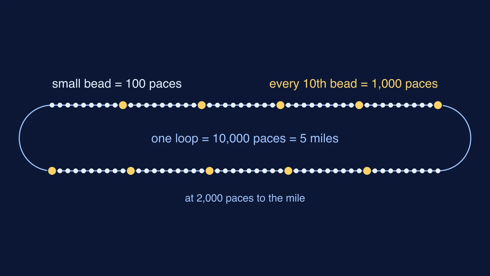
The pundits were trained to walk 2,000 paces to the mile by a British sergeant-major with a drum and a pace stick (Ward, Himalayan Journal). A mile is exactly 1.609344 km (Wikipedia: Mile), so each pace was about 0.80 metres.
To keep count, the pundits carried a Buddhist rosary with 100 beads instead of the usual 108. Each small bead stood for 100 paces, and every tenth bead was larger, marking 1,000 paces. One full loop of the rosary therefore meant 10,000 paces, or 5 miles.
A compass could be hidden in the prayer wheel or in the head of a hollowed-out stick, and the results were written down and kept among the prayers inside the wheel. Paces plus compass bearings give a route traverse: a chain of straight legs that can be drawn to scale. Late in the 1878-82 journey, when Kishen Singh was riding rather than walking, he had to adjust his pace-length figures, Ward notes.
How did boiling water tell him the altitude?
Among the instruments the pundits carried in disguise was a boiling-point thermometer for altitude (Ward). It works because the boiling point of a liquid falls when the air pressure falls, and air pressure falls as you climb; an instrument built on this idea is called a hypsometer.
Water's boiling point drops by about 1 °F for every 500 feet (152 m) of extra height, and a table based on standard atmospheric pressure puts it at about 89.8 °C at 3,048 m (Wikipedia: High-altitude cooking). So a surveyor who read the thermometer carefully, to a fraction of a degree, could estimate the height of a camp or a pass. If you want the physics behind those tables, our post on the Clausius-Clapeyron equation and water's boiling point in Shimla works through it.
If the link between air pressure and boiling is hard to picture, the Fermi Simulation Lab has interactive simulations for ideas that are easier to see than to read.
How can you pace your school ground like a pundit?
You need a measuring tape, a string of ten beads (or ten pebbles in a pocket), a notebook and a friend. Your pace may well be shorter than the 0.80 m worked out above from the pundits' 2,000 paces to the mile, so the first job is to measure your own.
Calibrate. Tape out a straight 30 m line and walk it three times at your normal pace, counting steps.
Find your pace length: 30 m divided by your average step count.
Move one bead every 10 paces, so a full string means 100 paces.
Walk each side of the ground and write down its paces before starting the next.
Multiply paces by pace length, then draw the ground to scale, say 1 cm for 5 m.
Tape one side and work out your percentage error.
A worked example: suppose you take 41, 40 and 39 steps on the 30 m line. Your average is 40, so your pace is 30 ÷ 40 = 0.75 m. If the long side takes 112 paces, it is 112 × 0.75 = 84 m; a short side of 72 paces is 54 m. If the tape then shows the long side is 86 m, your error is 2 ÷ 86, about 2.3 per cent.
Kishen Singh trained under his cousin; read how Nain Singh Rawat secretly mapped Tibet, and for the triangulation side of the Survey's story, how William Lambton measured the Great Arc of India.