On this page
Nain Singh Rawat, born in 1830 in today's Pithoragarh district (Wikipedia: Nain Singh), crossed Tibet in 1865-66 for the Great Trigonometrical Survey of India with a rosary, a prayer wheel, a sextant and a thermometer. His map rested on careful counting and one piece of school physics: water boils cooler when the air pressure is lower.
How did Nain Singh Rawat secretly map Tibet?
Tibet was closed to British surveyors, so the Survey trained local men to travel disguised as traders, as a Royal Society archive post on mapping India explains. Captain Thomas Montgomerie of the Survey ran the scheme, and his account, published in 1868 without naming Nain Singh, is the Report of a route-survey made by Pundit, from Nepal to Lhasa in the Journal of the Royal Geographical Society (a free scan is on the Internet Archive). It describes the tricks:
The prayer wheel held slips of paper for bearings and pace counts instead of a prayer.
When someone approached, he spun the wheel; a man at prayer was seldom interrupted.
Latitudes came from a sextant, with mercury in his wooden drinking bowl as an artificial horizon.
Heights came from a thermometer read in boiling water.
He reached Lhasa on 10 January 1866 and stayed until 21 April, according to Montgomerie's report. Sven Hedin's summary in Southern Tibet (scanned page) totals the result: 1,200 miles of route survey, 31 latitudes and 33 heights found by boiling water.
How did prayer beads measure distance?
A Buddhist rosary normally has 108 beads; Montgomerie's 1868 report says the Survey's had 100, every tenth one larger. Nain Singh dropped one bead every 100 paces, so each large bead marked 1,000 paces.
Paces become distance only if every pace is the same length; the pundits were drilled to keep a 33-inch stride, according to Jules Stewart's history as cited by Wikipedia.
Worked example, one full rosary:
100 beads × 100 paces = 10,000 paces.
10,000 × 33 inches = 330,000 inches = about 8.4 km (5.2 miles).
Pair each stretch with its compass bearing and the route becomes a chain of vectors added head to tail.
How can boiling water tell you your altitude?
Water boils when its vapour pressure equals the air pressure. Higher up there is less air above you, so water boils cooler. Two published sources turn a thermometer into a height meter:
The NIST Chemistry WebBook data for water gives the pressure at which water boils at each temperature: about 100 °C at 101 kPa, and 87.9 °C at 64.7 kPa.
NASA's standard atmosphere model gives air pressure with height in the lower atmosphere: p = 101.29 × [(T + 273.1)/288.08]^5.256 kPa, where T = 15.04 − 0.00649h °C and h is in metres.
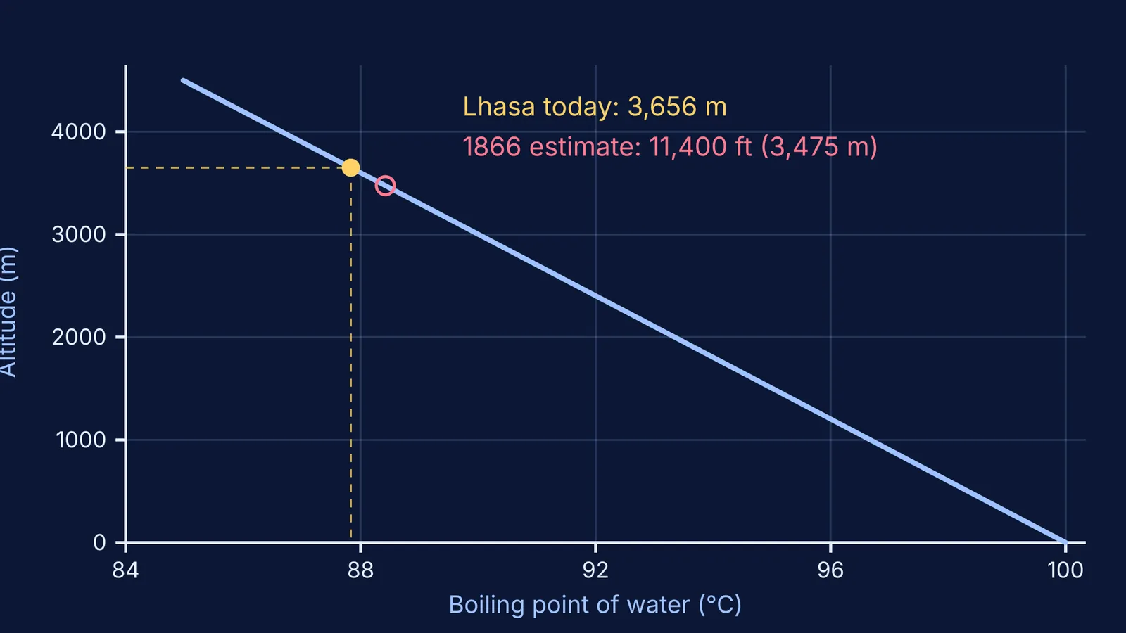
Worked example: your thermometer reads 87.9 °C at the boil. NIST says the air pressure is about 64.7 kPa, roughly two-thirds of sea level. Solving NASA's formula for that pressure gives about 3,630 m. Near that height, each 1 °C drop in boiling point means roughly 300 m more altitude, so half a degree of error moves the answer about 150 m.
How accurate was his height for Lhasa?
Montgomerie's report puts Lhasa at about 11,400 feet above the sea, which is about 3,475 m. Lhasa's elevation today is given as 3,656 m (Wikipedia: Lhasa). By the NIST and NASA figures above, that 180 m gap is only about 0.6 °C of boiling point. Some later accounts, including the Royal Society post, give his figure as 3,420 m instead.
Montgomerie flagged the risk: the thermometer broke near the end of the journey, so it was never tested at stations of known height.
In 1877 the Royal Geographical Society gave him its Patron's Medal for his surveys in Tibet and along the upper Brahmaputra (RGS Gold Medal list)). For more on the physics and maths behind his tools, read how Radhanath Sikdar calculated Everest's height and how Blaise Pascal tested air pressure on a mountain.
How can you try his methods yourself?
A weekend plan for a student and parent:
Measure your pace: count paces over 100 m three times and divide 100 m by the average.
Make a counter: 100 beads on a string, a different colour every tenth, one bead per 100 paces.
Map a loop: note the bead count and a phone-compass bearing at each turn, then draw the route to scale. How far your drawing misses the start is your accuracy.
Boil water, with an adult present: read it with a probe thermometer at home and again in the hills. Each degree is roughly 300 m (from the NIST and NASA data above), so compare the two readings rather than trusting one.
If pressure and boiling are hard to picture, the Fermi Simulation Lab has interactive simulations for ideas that are easier to see than to read. If a vapour-pressure numerical keeps going wrong, the Fermi Problem Library has worked problems with a step-by-step solver that explains the reasoning rather than printing an answer.
Nain Singh's tools were cheap; what made them work was knowing exactly what each bead and each degree meant.