
On this page
In April 1802, an infantry officer named William Lambton began chaining a straight baseline near Madras (now Chennai). That line anchored the Great Trigonometrical Survey, which mapped India with mathematics. His aim was to measure the length of a degree along a north-south line, a meridian, and use it to work out the shape of the Earth (William Lambton).
How did William Lambton measure the Great Arc of India?
He measured one distance on the ground very carefully, then got every other distance from angles.
The baseline. The survey began on 10 April 1802 with a baseline running from St Thomas Mount to Perumbauk Hill, about 7.5 miles (12.1 km) long (Great Trigonometrical Survey). The measurement was finished on 22 May 1802 (William Lambton). Lambton used a Ramsden chain of 40 links, each 2.5 feet, which measured 100 feet at 62 °F, and he corrected for the chain expanding in the Indian heat (same source). The chain was kept under tents to shield it from the sun (GPS World).
The angles. For angles, Lambton used the Great Theodolite made by William Cary, with a 36-inch horizontal circle; it weighed about half a ton and took twelve men to carry (William Lambton). From each station on high ground, surveyors sighted other stations and measured the angles between them.
The check. When the triangles reached Bangalore, Lambton compared a baseline measured there in 1804 with the length his calculations predicted, and the two differed by about 3.5 inches (8.9 cm) (William Lambton).
How does triangulation turn one line into a map?
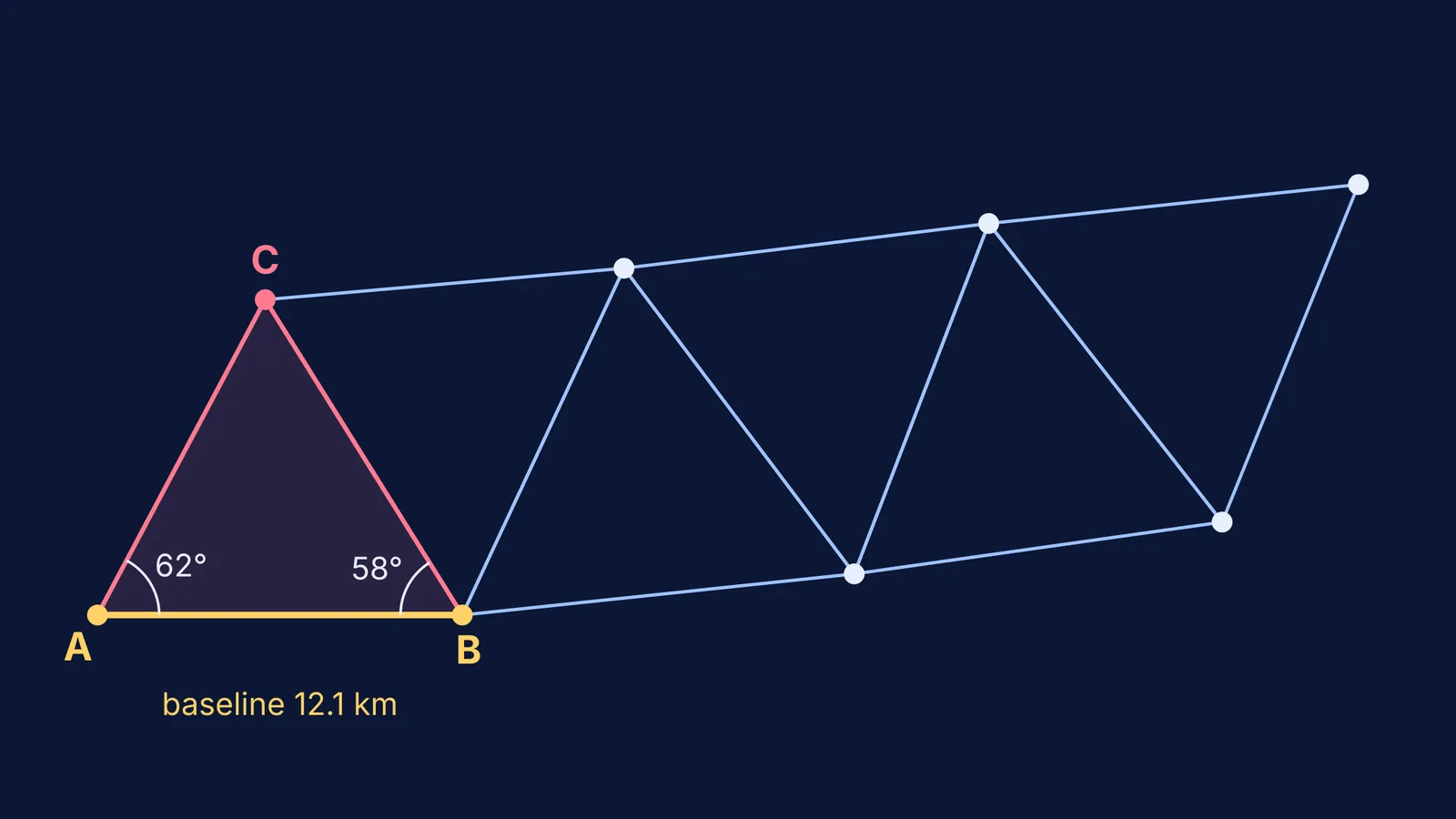
Triangulation means measuring one side of a triangle and two of its angles, then calculating the other two sides with the sine rule. A worked example, with Lambton's baseline length and simple angles:
Baseline AB = 12.1 km. At A, the angle between B and a distant hill C is 62°. At B, the angle between A and C is 58°.
The third angle is C = 180° − 62° − 58° = 60°.
The sine rule says AC / sin B = AB / sin C, so AC = 12.1 × sin 58° ÷ sin 60° = 12.1 × 0.848 ÷ 0.866 ≈ 11.85 km.
In the same way, BC = 12.1 × sin 62° ÷ sin 60° ≈ 12.34 km.
BC is now a known side. Measure two angles of the next triangle, BCD, and repeat.
Each new triangle borrows a side from the last, so one chained line can be carried across a country. But an angle error travels down the chain, which is why check baselines like Bangalore mattered. Surveying has other heroes too, such as Benjamin Banneker, who helped survey Washington, D.C. For practice, see our guide on choosing between the sine rule and the cosine rule.
If the sine rule step is where you get stuck, the Fermi Problem Library has worked problems with a step-by-step solver that explains the reasoning rather than printing an answer.
How did the Great Arc show the shape of the Earth?
In an 1818 Royal Society paper, Lambton reported an arc from latitude 8°9′38″ N to 18°3′23″ N, an amplitude of 9°53′45″, which he called the longest single arc yet measured on the globe (Philosophical Transactions, 1818). His three sections gave a degree of 60,472.83 fathoms at latitude 9°35′, 60,487.56 fathoms at 13°3′, and 60,512.78 fathoms at 16°35′ (same paper).
A fathom is exactly 6 feet, or 1.8288 m (Fathom). Multiply it out and Lambton's degree grows from about 110,593 m in the south to about 110,666 m in the north, roughly 73 m longer.
On a perfect sphere, every degree of latitude would be the same length. Degrees that lengthen towards the poles mean the surface is flatter there: Earth is an oblate spheroid, and one degree of latitude is about 110.6 km at the equator and 111.7 km at the poles (EBSCO Research Starters).
What happened to the Great Arc after Lambton?
Lambton died in January 1823 at Hinganghat (William Lambton). George Everest took over in 1823 and carried the arc north; the meridian arc from India's southern tip to Nepal ran about 2,400 km and took from 1806 to 1841 (George Everest). The wider survey, planned for five years, took nearly 70 (Great Trigonometrical Survey).
How can you try triangulation yourself?
You can repeat Lambton's method on a school ground:
Mark a baseline about 20 m long and measure it twice with a tape.
Choose a target you cannot walk to, such as a tree across a fence.
From each end, measure the angle between the baseline and the target with a large protractor, sighting along a straight stick.
Find the third angle, then use the sine rule for the distances.
Check yourself as Lambton did: lay a second baseline elsewhere and compare the answers.
If they disagree, check your angles first; a one-degree slip matters more than a few centimetres of tape. When the reason a formula works is the gap, the Fermi Concept Library gives each concept in mathematics its own lesson and its place in the map.