
On this page
On a hot day in April or May, the morning is often clear. By mid-afternoon, tall clouds pile up, and by evening there is thunder. The ground has spent all day heating the air above it, and the storm is what that heat turns into.
Why do thunderstorms often come in the afternoon?
The US National Weather Service puts it in one line: in the summer, thunderstorms typically develop in the afternoon when the sun heats air near the ground. It lists three ingredients: moisture, an unstable atmosphere, and some way to start the air moving.
Aiguo Dai analysed three-hourly weather reports from about 15,000 stations between 1975 and 1997 (Dai, Journal of Climate, 2001). Over most land areas, showery rain and thunderstorms were much more frequent in the late afternoon than at other times, with a daily swing of more than 50% of the average. The paper's explanation: solar heating of the ground produces a late-afternoon peak in convective available potential energy, the energy rising air can draw on.
How does hot ground make the air rise?
Soil, rock and concrete absorb sunlight and warm up, and the thin layer of air touching them warms by conduction. NOAA's JetStream guide explains that as the Sun heats the Earth's surface, some heat is transferred to the air, which creates different air densities. The warmer, lighter air is pushed upwards like a bubble in water, cooler air flows in to replace it, and a convection current forms.
Whether that bubble keeps going depends on stability. NOAA defines unstable air as air that continues to rise when given a nudge upward. Each hour of sunshine warms the lowest air further, so the atmosphere grows more unstable as the day goes on. Our post on how convection currents form in a heated tank shows the loop of rising and sinking air.
What happens to rising air as it climbs?
Pressure falls with height, so a rising bubble expands and cools. Unsaturated air cools at the dry adiabatic lapse rate, which is 9.8 °C per kilometre.
At some height the bubble cools to its dew point. Water vapour condenses into droplets, and you see the flat bottom of a cloud (more in how to predict the cloud base of rising air).
Condensation also releases heat. The latent heat of condensation is about 2.5 × 10⁶ J for every kilogram of water vapour that condenses. That textbook treats saturated air as cooling at a simplified 4.5 °C per kilometre, about half the dry rate. So inside the cloud, rising air stays warmer than its surroundings for longer and keeps climbing, building what NOAA calls the tall cumulonimbus clouds that make up a thunderstorm.
Worked example: a pre-monsoon afternoon
A rule of thumb gives the cloud-base height as 0.125 km for every °C between the air temperature and the dew point. Try it on a hot day in north India, with illustrative readings:
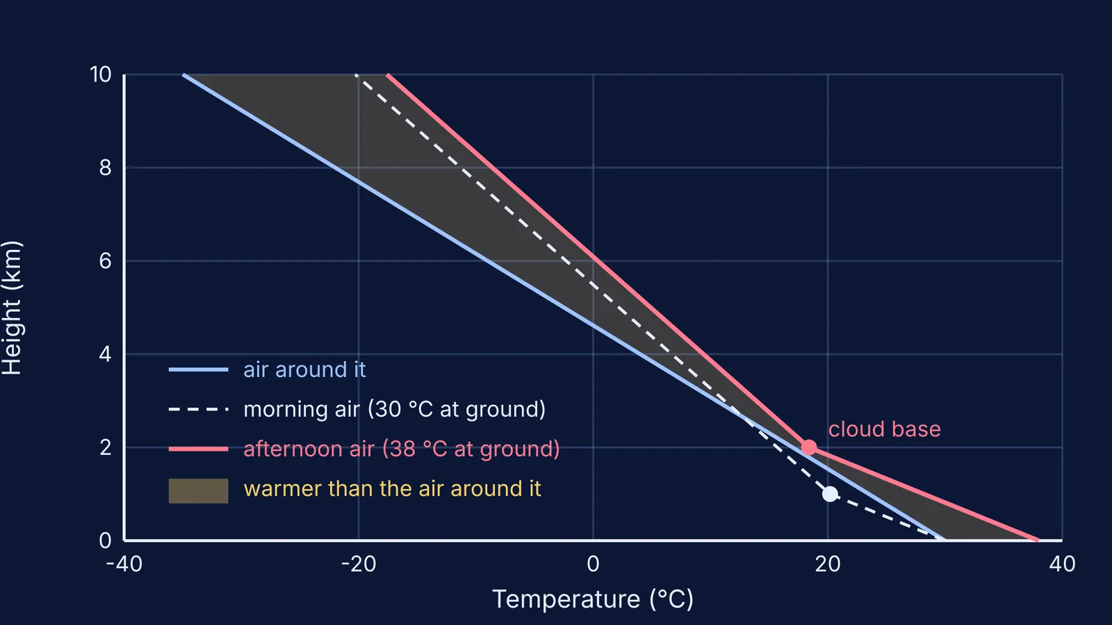
At 8 am the air is 30 °C and the dew point is 22 °C. The gap is 8 °C, so cloud base = 0.125 × 8 = 1.0 km.
By 3 pm the ground has heated the air to 38 °C, and the dew point is still 22 °C. The gap is 16 °C, so cloud base = 0.125 × 16 = 2.0 km.
Rising from the ground to 2 km, the afternoon air cools by 9.8 × 2 = 19.6 °C, reaching about 18.4 °C at the cloud base.
Above that, it cools at the slower saturated rate. If it is still warmer than the air around it, it keeps rising, and the cloud grows into a cumulonimbus.
The diagram at the top plots these numbers, assuming the surrounding air cools at 6.5 °C per km from 30 °C. Then the morning air starts colder than its surroundings and needs a push, while the afternoon air stays warmer all the way up.
Thunderstorms are common across India before the monsoon. In a study of 276 Indian observatories, G. K. Manohar and A. P. Kesarkar found that in the pre-monsoon season a major part of India sees frequent and widespread thunderstorms. One regional example is explained in the physics of Kalbaishakhi, the Nor'wester storms of Bengal.
How do you explain it in an exam answer?
Give the chain of causes in order:
The sun heats the ground through the morning.
The ground heats the air above it by conduction.
The warm, less dense air rises in convection currents.
As it rises, the air expands and cools at about 9.8 °C per km.
At the dew point, the water vapour condenses and forms a cloud.
Condensation releases latent heat, which keeps the air rising and builds a tall cumulonimbus cloud.
Convection is easier to follow when you can watch it move. The Fermi Simulation Lab has interactive simulations for ideas that are easier to see than to read, and the Fermi Concept Library has a lesson for every concept in physics, chemistry and more.