

On this page
In short
Kalbaishakhi, or Nor'wester storms, are severe localized thunderstorms in eastern India and Bangladesh. Triggered by intense surface heating and moist air from the Bay of Bengal, they bring gale-force winds often exceeding 100 km/h, torrential rain, and lightning during the pre-monsoon months.
The pre-monsoon months of March, April, and May in eastern India bring intense heat, high humidity, and a sudden, violent release of energy. During these months, Kalbaishakhi storms sweep across the region, uprooting trees, damaging structures, and providing relief from the mid-day heat.
What are Kalbaishakhi or Nor'wester storms in Bengal?
Kalbaishakhi (meaning the calamity of the month of Baisakh) or Nor'westers are severe, localized thunderstorms that strike West Bengal, Odisha, Jharkhand, Assam, and Bangladesh [https://en.wikipedia.org/wiki/Nor%27westers]. They are classified as severe local storms that bring gale-force winds often exceeding 100 km/h, torrential rain, and lightning. Because the squall lines travel from the northwest to the southeast, they earned the English name Nor'westers.
These storms are not typical monsoon rains. They are fierce, short-lived convective events that release massive amounts of atmospheric energy. While they are known for their destructive power, they are also a defining feature of the region's climate. The arrival of these storms marks a significant shift in weather patterns, providing a transition between the dry, scorching summer and the heavy, continuous rainfall of the incoming monsoon season.
How do Kalbaishakhi thunderstorms form?
The physics of a Kalbaishakhi storm relies on intense convection and the meeting of contrasting air masses.
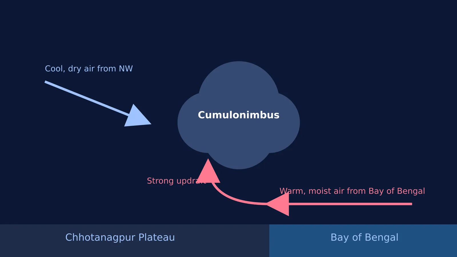
The process begins over the Chhotanagpur Plateau, located in Bihar and Jharkhand [https://en.wikipedia.org/wiki/Nor%27westers]. During the morning, the plateau heats up rapidly under clear skies, creating a strong low-pressure zone. This low pressure draws in warm, moist air from the Bay of Bengal in the lower atmosphere. At the same time, higher altitudes experience an influx of dry and cool air flowing in from the northwest.
When these two air masses collide, the warm maritime air is forced sharply upward. As the moist air rises, it expands and cools, and the water vapour condenses into liquid water. This condensation releases latent heat, which warms the surrounding air, making it rise even faster. This positive feedback loop is what builds towering cumulonimbus clouds.
The rapid vertical ascent of moist air is a textbook example of atmospheric instability. If you find it hard to picture how pressure gradients drive air masses, the Fermi Simulation Lab lets you change surface temperatures and watch convection currents form in real time. Understanding these pressure changes is as important for meteorology as knowing how isobaric and isochoric heat differ in thermodynamics.
Why do Nor'wester storms form in the afternoon?
Timing is tied directly to surface heating. The ground needs several hours of intense solar radiation to reach its peak temperature. By late afternoon or early evening, the temperature gradient between the hot land and the incoming sea breeze is at its steepest.
This extreme gradient triggers the rapid updrafts that form the storm. Once the cumulonimbus cloud reaches the upper troposphere, it flattens into an anvil shape. The water droplets and ice crystals within the cloud eventually become too heavy for the updrafts to support. They fall as torrential rain and hail, dragging cold air down with them. This sudden downdraft hits the ground and spreads outward as a violent squall.
The mechanics of downdrafts and squall lines demonstrate the powerful forces of thermodynamics and fluid dynamics in our atmosphere. The study of how weather fronts develop relies heavily on these physical models, pioneered by scientists like Vilhelm Bjerknes.
Are Kalbaishakhi storms beneficial for crops?
Despite their destructive winds and the risk of lightning strikes, these squalls are essential for agriculture in eastern India. The sudden, intense rainfall is highly beneficial for Kharif crops such as jute and paddy in Bengal, and it provides crucial moisture for tea cultivation in Assam [https://en.wikipedia.org/wiki/Nor%27westers].
They also provide a much-needed break from the severe heat, clearing the atmospheric refraction and haze of the pre-monsoon summer. Without these storms, the soil would become too dry and hard to prepare for the main monsoon planting season. The rain softens the earth, allowing farmers to begin ploughing and sowing their fields in anticipation of the heavier monsoon rains.
Checklist: Reading the signs of a convective storm
If you are studying atmospheric physics or just watching the weather, here is a quick checklist of the sequence that forms a Nor'wester:
Intense morning heat: Clear skies allow maximum solar radiation to heat the ground, forming a low-pressure area over regions like the Chhotanagpur Plateau.
Moisture influx: Humidity rises rapidly as sea breezes move inland towards the low-pressure zone from the Bay of Bengal.
Cloud towers: Cumulus clouds grow vertically into dark, anvil-shaped cumulonimbus formations as latent heat fuels atmospheric instability.
Sudden downdraft: The temperature drops sharply as the storm breaks, bringing torrential rain, hail, and strong squalls moving from the northwest to the southeast.


