
On this page
Every May, Rajasthan braces for the andhi, a brown wall of wind that turns afternoon into dusk. It is what happens when very hot, dry land meets a little moisture and a lot of rising air.
What counts as a dust storm?
The India Meteorological Department (IMD) defines a dust storm as dust or sand "energetically lifted to great heights by a strong and turbulent wind", with surface visibility below 1000 m (IMD glossary). The same glossary sets India's pre-monsoon season as March to May.
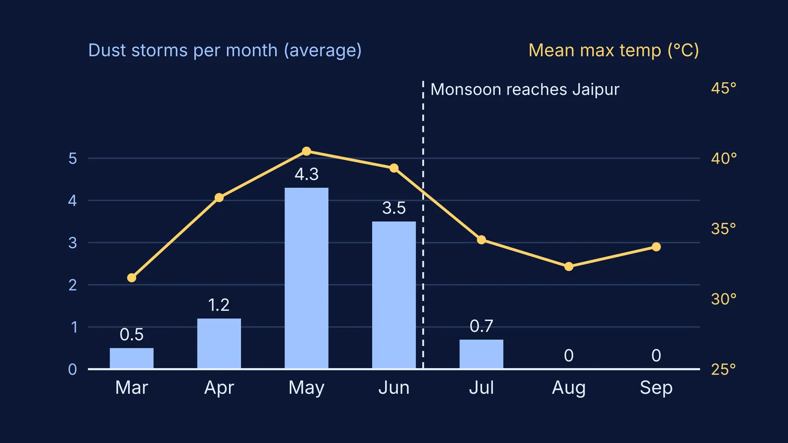
IMD's Climate of Jaipur report notes that dust storms are locally called "Andhi" and are a prominent feature of the hot season. In Jaipur they average 0.5 a month in March, 1.2 in April and 4.3 in May, based on weather records for 1985 to 2005.
Why does Rajasthan get dust storms before the monsoon?
Four things line up in May and June, and the IMD Jaipur report documents each one.
Extreme heating. Jaipur's average maximum temperature in May is 40.5 °C, and daytime temperatures stay around 45 °C on many occasions.
Very dry ground. Normal May rainfall in Jaipur is just 18.7 mm, and minimum humidity falls to about 17% by the end of May. Loose, dry soil has nothing holding its grains together.
Convection. IMD defines convection as heat transfer within a fluid involving the movement of large volumes of it (IMD glossary). Hot ground heats the air touching it, which expands and rises; the Jaipur report notes that wind speed increases from morning to evening.
A trigger with a little moisture. Western disturbances, weather systems that IMD says originate over the Mediterranean, Caspian and Black Seas (IMD glossary), strike northwest India in this season and bring a little moisture. Thunderclouds grow, and the Jaipur report says the downdraft from these cumulonimbus clouds gives rise to dust storms and squalls, usually in the afternoon or late at night.
Rising air leaves lower pressure behind, and air flows in from the surroundings: the same pressure-driven wind as a sea breeze on the coast, only far more violent.
How does a storm cloud turn into a wall of dust?
The US National Severe Storms Laboratory defines a downdraft as "a small-scale column of air that rapidly sinks toward the ground", and a gust front as the leading edge of rain-cooled air (NOAA NSSL). This cold, dense air falls, hits the ground and spreads sideways as a gusty front.
Over the dry, loose soil of Rajasthan, that front scoops up dust and pushes it ahead as a wall. NSSL calls this a haboob: a wall of dust pushed out along the ground from a thunderstorm downdraft. The IMD Jaipur report records that the temperature drops suddenly by about 5-7 °C after a dust storm passes: the cool outflow air has arrived.
If rising and sinking air is hard to picture, the Fermi Simulation Lab has interactive simulations for ideas that are easier to see than to read.
Why do the dust storms stop once the monsoon arrives?
The southwest monsoon normally reaches Jaipur around 25 June, according to the IMD Jaipur report. Dust storms average 3.5 days in June and 0.7 in July, and none in August or September. The report says dust storms and hail stop with the arrival of the monsoon.
Jaipur's average rainfall jumps from 69 mm in June to 221 mm in July, and wet soil clumps together, leaving downdrafts little loose dust to lift. NASA's Earth Observatory described a storm that began in Rajasthan on 12 June 2018, when high winds kicked up dust from the Thar Desert, and noted that monsoon rains normally "help dampen and remove dust" (NASA Earth Observatory).
The same heat drives the hot, dry Loo winds of north India; for dust physics on another world, see why Mars has planet-wide dust storms.
How much lighter is hot air than cool air?
At the same pressure, the ideal gas law (PV = nRT) says air density is proportional to 1/T, with T in kelvin.
Air over ground on a May afternoon at 45 °C, a temperature Jaipur reaches on many days (IMD Jaipur report): T = 318 K.
Air nearby at a cooler 30 °C: T = 303 K.
Density ratio of hot to cool air = 303 / 318 ≈ 0.95.
So the hot air is about 5% less dense, and buoyancy pushes it upward. In reverse, rain-cooled air in a downdraft is denser than its surroundings, so it sinks.
As a five-line exam answer:
Intense heating of dry land in May
Convection: hot, less dense air rises and leaves low pressure behind
Moisture from western disturbances builds cumulonimbus clouds
Cold, dense downdrafts hit the ground and spread as gust fronts
Dry, loose soil is lifted, until monsoon rain wets it
If convection or the gas laws still feel shaky, the Fermi Concept Library has a lesson for every concept in physics, chemistry, biology, mathematics and computing.
Next time an andhi rolls in, look for the sudden cool gust: that is the dense, sinking air from the worked example.