

On this page
Every year between May and June, scorching winds sweep across Punjab, Haryana, Rajasthan, Delhi, Uttar Pradesh, and Bihar. Known as the Loo, these dry, gusty westerlies routinely push afternoon temperatures beyond 45°C (113°F), according to the India Meteorological Department. Stepping outdoors feels like opening the door of an industrial oven.
The IMD declares a heat wave in the northern plains when station temperatures reach at least 40°C with departures of 4.5°C to 6.4°C above normal, or whenever actual temperatures reach 45°C (D. S. Pai et al., 2013, MAUSAM). The Loo is the primary engine behind these extremes. Understanding why it is so hot and dry requires examining the physics of solar insolation, molecular conduction, deep convection, and continental advection.
Where do Loo winds come from and why are they dry?
As outlined in the NCERT Class 9 Geography curriculum, the Loo is a defining feature of the Indian hot weather season. These winds originate over the hyper-arid expanses of the Thar Desert in Rajasthan, the Cholistan Desert, and the sun-baked plateaus of Balochistan.
Because these origin zones lie deep within a continental landmass without major water bodies, air masses begin their journey with very low absolute humidity. As air heats up, its capacity to hold water vapour expands exponentially through the Clausius-Clapeyron relation. With no surface moisture to supply vapour, relative humidity plunges to between 5% and 15%.
To see how heating alone creates this extreme dryness, consider a parcel of air over Rajasthan at 06:00 with a temperature of 30°C and an actual vapour pressure of 1.27 kPa:
At 30°C, the saturation vapour pressure is roughly 4.24 kPa, giving a relative humidity of RH = (1.27 / 4.24) × 100% ≈ 30.0%.
By 14:00, intense solar heating drives air temperature to 45°C while actual vapour pressure remains 1.27 kPa.
Because saturation vapour pressure rises to 9.58 kPa at 45°C, afternoon relative humidity falls to RH = (1.27 / 9.58) × 100% ≈ 13.3%.
Without losing any moisture, the air mass becomes twice as desiccating simply because higher temperature expands its capacity to hold water vapour.
How do conduction and convection superheat the boundary layer?
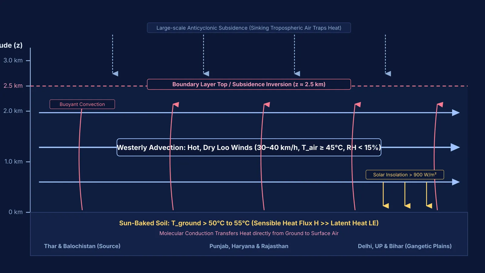
The heating of the Loo begins with surface energy partitioning at ground level. During May and June, a near-vertical solar angle delivers incoming solar insolation exceeding 900 W/m² onto bare soil (K. G. Vernekar et al., 2003, Boundary-Layer Meteorology).
Under normal conditions with moist soil, solar energy is largely absorbed as latent heat to evaporate water. In the pre-monsoon summer, however, soil moisture across northwest India is nearly zero. Atmospheric physicists quantify this balance using the Bowen ratio, the ratio of sensible heat flux H to latent heat flux LE (β = H / LE). Field measurements from the Land Surface Processes Experiment (LASPEX) confirmed that sensible heat dominates pre-monsoon energy exchange across western India.
With negligible evaporative cooling, ground surface temperatures exceed 50°C to 55°C. Heat transfers from this scorching ground into the lowest air layer via molecular conduction (to explore how thermal gradients govern heat flow, read thermal conduction and heat flow).
As this surface air heats, it expands according to Charles's law. Its lower density drives buoyant vertical convection currents that build a deep Convective Boundary Layer stretching 2.0 to 2.5 km into the troposphere. Large-scale anticyclonic subsidence aloft acts like an atmospheric lid, trapping this superheated air in a well-mixed layer (J. V. Ratnam et al., 2016, Scientific Reports).
Why does advection make Loo winds hotter as they travel?
When a fluid parcel travels away from its primary heat source, ordinary intuition suggests it should cool down. The Loo behaves differently.
In NCERT Class 11 Geography, the Loo is cited as the prime example of heat transfer by advection—the horizontal transport of heat by wind. Intense solar insolation develops a thermal low-pressure trough from the Thar Desert across the Gangetic plains. This pressure gradient pulls dry westerly winds eastward across Punjab, Haryana, Delhi, Uttar Pradesh, and Bihar at sustained speeds of 30 to 40 km/h.
As these winds travel eastward, they blow across plains that have also been baked by intense pre-monsoon sunlight. Instead of losing thermal energy, the advecting air mass continuously absorbs additional sensible heat conducted from the ground along its entire path.
In the Fermi Simulation Lab, interactive simulations let you explore dynamic heat transfer and boundary layer convection that are easier to see than to read.
Why do Loo winds dehydrate the human body so rapidly?
According to the IMD Heat Wave Guidelines, extreme heat stresses human thermoregulation by disrupting how the body maintains core temperature near 37°C against skin temperatures of 34°C to 35°C. When ambient air temperature exceeds skin temperature, the direction of convective heat transfer flips:
q_conv = h_c × (T_air − T_skin)
Because T_air (45°C) exceeds T_skin (34°C), heat flows directly from the surrounding air into the body. Sustained winds of 35 km/h strip away the protective boundary layer of still air next to your skin, increasing the convective heat transfer coefficient h_c and accelerating heat gain.
In this regime, sweating is the only physiological mechanism left to shed heat (review the physics of phase change in evaporation and latent heat and calorimetry and thermal conduction). Evaporating 1 g of sweat absorbs roughly 2,426 J of latent heat at body temperature. Because the Loo's relative humidity is below 15%, perspiration evaporates instantly before visible droplets can form. Fluid loss under sustained exposure can reach 1.0 to 1.5 litres per hour.
When fluid loss reduces circulating blood volume, sweating diminishes and core temperature can surge past 40°C (104°F), causing heatstroke.
The Fermi Concept Library covers every concept in thermodynamics and fluid physics, each with its own lesson and its place in the map.


